Country:
 Germany
Region:
City:
Latitude and Longitude:
Time Zone:
Postal Code:
IP information under different IP Channel
ip-api
Country
Region
City
ASN
Time Zone
ISP
Blacklist
Proxy
Latitude
Longitude
Postal
Route
IPinfo
Country
Region
City
ASN
Time Zone
ISP
Blacklist
Proxy
Latitude
Longitude
Postal
Route
MaxMind
Country
Region
City
ASN
Time Zone
ISP
Blacklist
Proxy
Latitude
Longitude
Postal
Route
Luminati
Country
DEASN
Time Zone
Europe/Berlin
ISP
DE-CIX Management GmbH
Latitude
Longitude
Postal
db-ip
Country
Region
City
ASN
Time Zone
ISP
Blacklist
Proxy
Latitude
Longitude
Postal
Route
ipdata
Country
Region
City
ASN
Time Zone
ISP
Blacklist
Proxy
Latitude
Longitude
Postal
Route
Popular places and events near this IP address
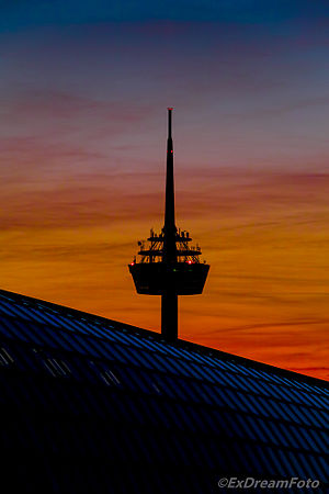
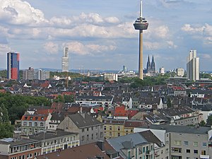
Colonius
Tower in Cologne
Distance: Approx. 1601 meters
Latitude and longitude: 50.94722222,6.93194444
Colonius is the Cologne telecommunications tower, which was finished in 1981. The Colonius possesses a cafeteria, viewing platform, and a restaurant, apart from antennas for radio relay and radio services within the VHF range. Because of a missing leaseholder, the visitor's area including restaurant and viewing platform has been closed since 1992.
Helios AG
Distance: Approx. 384 meters
Latitude and longitude: 50.951,6.914
The Helios AG für elektrisches Licht und Telegraphenanlagenbau was a German electrical engineering company. Founded in 1882, it existed until its liquidation in 1930. The company was based in the town of Ehrenfeld, which was incorporated into Cologne in 1888.
Ehrenfeld, Cologne
Borough of Cologne in North Rhine-Westphalia, Germany
Distance: Approx. 704 meters
Latitude and longitude: 50.9464,6.91833
Ehrenfeld (German: Köln-Ehrenfeld [kœln ˈʔeːʁənfɛlt]; Kölsch: Ihrefäld [ˈi²ʁəfɛlt]) is a borough (Stadtbezirk) of the City of Cologne in Germany. It includes the seven quarters Bickendorf, Bocklemünd, Mengenich, Ehrenfeld, Neuehrenfeld, Ossendorf and Vogelsang. It has about 109,500 inhabitants (as of December 2020) and covers an area of 23.98 square kilometres.

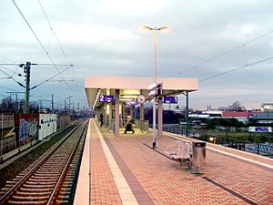
Köln-Ehrenfeld station
Railway station in Cologne, Germany
Distance: Approx. 645 meters
Latitude and longitude: 50.9516,6.9177
Köln-Ehrenfeld is a railway station situated at Ehrenfeld, Cologne in western Germany on the Cologne–Aachen railway. It was opened with the first part of the line in 1839. It is served by Rhine-Ruhr S-Bahn and regional services.

Köln-Lövenich station
Railway station in Cologne, Germany
Distance: Approx. 1486 meters
Latitude and longitude: 50.94825,6.88819
Köln-Lövenich is a railway station situated at Lövenich, Cologne in western Germany on the Cologne–Aachen railway. It is classified by Deutsche Bahn as a category 5 station. Lövenich station was opened on 2 July 1840 with the second phase of construction of the Cologne–Aachen railway at line-km 9.0 and was the western terminus of the line for about a year.
Köln-Müngersdorf Technologiepark station
Railway station in Germany
Distance: Approx. 1486 meters
Latitude and longitude: 50.94825,6.88819
Köln-Müngersdorf/Technologiepark is a railway station situated at Müngersdorf, Cologne in western Germany. The station was opened on 15 December 2002 on a section of the Cologne–Aachen railway that was opened by the Rhenish Railway Company between Cologne and Müngersdorf on 2 August 1839. The station has a partially covered island platform, which is connected by two sets of stairs and a lift to the street below, on which there is a Kölner Verkehrsbetriebe (Cologne Transport) bus stop.
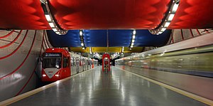
Rochusplatz station
Underground train station in Cologne, Germany
Distance: Approx. 940 meters
Latitude and longitude: 50.95666667,6.90305556
Rochusplatz is an underground station on the Cologne Stadtbahn lines 3 and 4 in Cologne. The station is located on Venloer Straße at its intersection with Äußere Kanalstraße in the district of Ehrenfeld. The station was opened in 1992 and consists of a mezzanine and one island platform with two rail tracks.

Arkadaş Theater
Distance: Approx. 632 meters
Latitude and longitude: 50.95361111,6.915
Arkadaş Theater is a theatre in Cologne, North Rhine-Westphalia, Germany.

Melaten cemetery
Cemetery in Cologne, Germany
Distance: Approx. 1287 meters
Latitude and longitude: 50.93944444,6.91916667
Melaten is the central cemetery of Cologne, North Rhine-Westphalia, which was first mentioned in 1243. It was developed to a large park, holding the graves of notable residents.

Aachener Straße/Gürtel station
Railway station in Germany
Distance: Approx. 1365 meters
Latitude and longitude: 50.93694444,6.90861111
Aachener Straße/Gürtel is an interchange station on the Cologne Stadtbahn lines 1, 7, and 13 in the district of Lindenthal in Cologne, North Rhine-Westphalia, Germany. The station is located at the junction of Aachener Straße and the Cologne Belt (Gürtel). The station has four separate side platforms, each on one of the four median strips facing the junction.

Live Music Hall
Nightclub and venue in Ehrenfeld, Cologne, Germany
Distance: Approx. 55 meters
Latitude and longitude: 50.94916667,6.91011111
Live Music Hall (locally known as "LMH" or "Live") is a nightclub and music venue located in Ehrenfeld, Cologne, Germany.

St Peter's Church (Cologne)
Church in Cologne
Distance: Approx. 884 meters
Latitude and longitude: 50.95555,6.91689
St Peter's Church (Sankt Peter) is a Roman Catholic church in Cologne, run by the Jesuits. The painter Rubens was baptised in the church and his father was later buried there. Rubens' Crucifixion of St Peter is on display in the church.
Weather in this IP's area
overcast clouds
20 Celsius
20 Celsius
20 Celsius
22 Celsius
1012 hPa
75 %
1012 hPa
1006 hPa
10000 meters
1.54 m/s
260 degree
100 %
06:57:20
20:02:56