91.213.89.45 - IP Lookup: Free IP Address Lookup, Postal Code Lookup, IP Location Lookup, IP ASN, Public IP
Country:
 Slovenia
Region:
City:
Location:
Time Zone:
Postal Code:
ISP:
ASN:
language:
User-Agent:
Proxy IP:
Blacklist:
IP information under different IP Channel
ip-api
Country
Region
City
ASN
Time Zone
ISP
Blacklist
Proxy
Latitude
Longitude
Postal
Route
db-ip
Country
Region
City
ASN
Time Zone
ISP
Blacklist
Proxy
Latitude
Longitude
Postal
Route
IPinfo
Country
Region
City
ASN
Time Zone
ISP
Blacklist
Proxy
Latitude
Longitude
Postal
Route
IP2Location
91.213.89.45Country
siRegion
nova gorica
City
solkan
Time Zone
Europe/Ljubljana
ISP
Language
User-Agent
Latitude
Longitude
Postal
ipdata
Country
Region
City
ASN
Time Zone
ISP
Blacklist
Proxy
Latitude
Longitude
Postal
Route
Popular places and events near this IP address

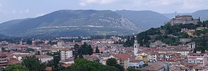
Nova Gorica
Town in Slovenian Littoral, Slovenia
Distance: Approx. 1795 meters
Latitude and longitude: 45.95583333,13.64333333
Nova Gorica (pronounced [ˈnɔ̀ːʋa ɡɔˈɾìːtsa] ) is a town in western Slovenia, on the border with Italy. It is the seat of the Municipality of Nova Gorica. Nova Gorica is a planned town, built according to the principles of modernist architecture after 1947, when the Paris Peace Treaty established a new border between Yugoslavia and Italy, leaving nearby Gorizia outside the borders of Yugoslavia and thus cutting off the Soča Valley, the Vipava Valley, the Gorizia Hills and the northwestern Karst Plateau from their traditional regional urban centre.

Goriška
Historical region in Slovenia
Distance: Approx. 2118 meters
Latitude and longitude: 45.95529444,13.63482222
Goriška (English: the Gorizia Region) is a historical region in western Slovenia on the border with Italy. It comprises the northern part of the wider traditional region of the Slovenian Littoral (Primorska). The name Goriška is an adjective referring to the city of Gorizia, its historical and cultural centre.

Nova Gorica Sports Park
Distance: Approx. 1840 meters
Latitude and longitude: 45.95583333,13.64138889
Nova Gorica Sports Park (Slovene: Športni park Nova Gorica) is a multi-purpose sports venue in Nova Gorica, Slovenia. It is currently used mostly for football matches and is the home ground of ND Gorica. The stadium was built in 1964 and has a capacity of 3,100 seats.

Solkan Bridge
Arch bridge over the Soča River
Distance: Approx. 864 meters
Latitude and longitude: 45.978981,13.651822
The Solkan Bridge (Slovene: Solkanski most, Italian: Ponte di Salcano) is a 219.7-meter (721 ft) arch bridge over the Soča River near Nova Gorica in western Slovenia (by railway terminology it is a viaduct). With an arch span of 85 meters (279 ft), it is the world's longest stone arch railroad bridge (and second-longest stone arch bridge, after Germany's Syratal Viaduct, a road bridge). It holds this record because later construction technology used reinforced concrete to build bridges.

Kromberk
Place in Slovenian Littoral, Slovenia
Distance: Approx. 2015 meters
Latitude and longitude: 45.95915,13.66857778
Kromberk (pronounced [ˈkɾoːmbɛɾk]; Italian: Moncorona, German: Cronberg bei Görz) is a settlement in the Municipality of Nova Gorica in western Slovenia. Together with its two satellite settlements of Ajševica and Loke, it forms one of the four major suburbs of Nova Gorica (the others being Solkan, Rožna Dolina, and Pristava).

Solkan
Place in Slovenian Littoral, Slovenia
Distance: Approx. 369 meters
Latitude and longitude: 45.96949722,13.64549167
Solkan (pronounced [ˈsoːu̯kan] or [sɔu̯ˈkan]; Italian: Salcano, German: Sollingen or Salcano) is a settlement in the Municipality of Nova Gorica in the Gorizia region of western Slovenia, at the border with Italy. Although it forms a single urban area with the city of Nova Gorica today, it has maintained the status of a separate urban settlement due to its history and the strong local identity of its residents. The parish church in the settlement is dedicated to Saint Stephen and belongs to the Diocese of Koper.

Nova Gorica Grammar School
Public gymnasium school in Nova Gorica, Slovenia
Distance: Approx. 1636 meters
Latitude and longitude: 45.95694444,13.64555556
Nova Gorica Grammar School or Gimnazija Nova Gorica, is a coeducational secondary school in western Slovenia. Located in Nova Gorica, the school is for students aged between 15 and 19. It has been certified as one of the top European Parliament Ambassador Schools in the country.

Transalpina/Europe Square
Square divided between the towns of Gorizia, Italy and Nova Gorica, Slovenia
Distance: Approx. 2150 meters
Latitude and longitude: 45.955,13.63472222
Transalpina Square (Italian: Piazza della Transalpina, meaning "Square of the Transalpina [Railway Line])"; Slovene: Trg Evrope, meaning "Europe Square"), is a square divided between the towns of Gorizia, northeastern Italy, and Nova Gorica, southwestern Slovenia. The railway station of Nova Gorica is located at the eastern end of the square, on the Slovenian side.

Nova Gorica railway station
Railway station in Nova Gorica, Slovenia
Distance: Approx. 2128 meters
Latitude and longitude: 45.955,13.63527778
Nova Gorica railway station (Slovene: Železniška postaja Nova Gorica; Italian: Stazione di Nova Gorica) serves the town and municipality of Nova Gorica, in the Slovenian Littoral region of Slovenia, and is also accessible from the town of Gorizia, Italy. The station forms part of the Bohinj Railway, between Jesenice, Slovenia, and Trieste, Italy. Due to its geographical position, it has undergone several changes of nationality and name.
Sabotin
Mountain ridge on the border between Slovenia and Italy
Distance: Approx. 2206 meters
Latitude and longitude: 45.98841389,13.63478056
Sabotin (Italian: Sabotino, Friulian: Mont di San Valantin) is 609-metre-high (1,998 ft) mountain ridge overlooking Gorizia, Nova Gorica, and Solkan on the border between Slovenia and Italy. At its foot stands the Solkan Bridge spanning the Soča River.

Škabrijel
Mountain in Slovenia
Distance: Approx. 2254 meters
Latitude and longitude: 45.9762,13.6777
Škabrijel (Italian: Monte San Gabriele) is a 646-metre (2,119 ft) hill above the town of Nova Gorica in Slovenia. The hill is named after the Archangel Gabriel.

Co-Cathedral of Christ the Saviour, Nova Gorica
Church in Nova Gorica, Slovenia
Distance: Approx. 1262 meters
Latitude and longitude: 45.9601,13.6507
The Co-Cathedral of Christ the Saviour (Slovene: Stolna cerkev Kristus Odrešenik), also called Nova Gorica Cathedral, is the name given to a religious building that is affiliated with the Catholic Church and serves as the co-cathedral or alternate cathedral of the Diocese of Koper. It is located in Nova Gorica, a city in the European country of Slovenia. It was built in 1982 by architect Franc Kvaternik project.
Weather in this IP's area
light rain
6 Celsius
6 Celsius
5 Celsius
7 Celsius
1022 hPa
89 %
1022 hPa
994 hPa
10000 meters
0.89 m/s
0.89 m/s
76 degree
100 %