Country:
 Poland
Region:
City:
Latitude and Longitude:
Time Zone:
Postal Code:
IP information under different IP Channel
ip-api
Country
Region
City
ASN
Time Zone
ISP
Blacklist
Proxy
Latitude
Longitude
Postal
Route
IPinfo
Country
Region
City
ASN
Time Zone
ISP
Blacklist
Proxy
Latitude
Longitude
Postal
Route
MaxMind
Country
Region
City
ASN
Time Zone
ISP
Blacklist
Proxy
Latitude
Longitude
Postal
Route
Luminati
Country
PLASN
Time Zone
Europe/Warsaw
ISP
T-Mobile Polska S.A.
Latitude
Longitude
Postal
db-ip
Country
Region
City
ASN
Time Zone
ISP
Blacklist
Proxy
Latitude
Longitude
Postal
Route
ipdata
Country
Region
City
ASN
Time Zone
ISP
Blacklist
Proxy
Latitude
Longitude
Postal
Route
Popular places and events near this IP address

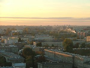
Praga-Południe
Warsaw District in Masovian Voivodeship, Poland
Distance: Approx. 1559 meters
Latitude and longitude: 52.241729,21.083867
Praga-Południe (Polish pronunciation: [ˈpraɡa pɔˈwudɲɛ]), also known by its anglicized names Praga-South, Praga South, and South Praga, is a district of the city of Warsaw, Poland located on the east bank of the Vistula River. It consists of Grochów, Gocław, Kamionek and Saska Kępa.
Grochów
Distance: Approx. 1277 meters
Latitude and longitude: 52.240807,21.087891
Grochów is a district of Warsaw, officially part of the borough of Praga-Południe although not connected at all to the historical "Praga" district. It is one of the most notable residential areas of right-bank Warsaw. There are many blocks of flats, as well as many pre-WWI houses.

Battle of Olszynka Grochowska
November Uprising battle 1831
Distance: Approx. 1697 meters
Latitude and longitude: 52.24861111,21.10777778
The Battle of Olszynka Grochowska, or the battle of Grochów, was fought on 25 February 1831 in the woods near Grochów, on the eastern outskirts of Warsaw. The Polish army, commanded by Józef Chłopicki, succeeded in preventing its Russian counterpart, under Hans Karl von Diebitsch, from crushing the uprising. However, the battle has also been described as an inconclusive bloodbath.

Kamionek, Warsaw
Distance: Approx. 1572 meters
Latitude and longitude: 52.2417,21.0836
Kamionek is a neighbourhood in Warsaw, located on the right bank of the Vistula river. It is the birthplace of the polish statesman Roman Dmowski. Formerly a village, in the 19th century, with the beginning of the Industrial Revolution in this part of the Russian Empire, it was transformed into a textile industry center.
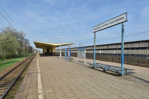
Warszawa Olszynka Grochowska railway station
Railway station in Warsaw, Poland
Distance: Approx. 1808 meters
Latitude and longitude: 52.24972222,21.10694444
Warszawa Olszynka Grochowska railway station is a railway station in the Praga Południe district of Warsaw, Poland. As of 2012, it is served by Koleje Mazowieckie, who run the KM7 services from Warszawa Zachodnia to Dęblin and by Szybka Kolej Miejska, who run the S1 services from Pruszków PKP to Otwock.

Gocławek
Neighbourhood in Praga Południe, Warsaw, Poland
Distance: Approx. 1244 meters
Latitude and longitude: 52.238142,21.119339
Gocławek is an officially designated neighbourhood within the Warsaw district of Praga Południe. It is located in the north-eastern part of Praga-Południe and is roughly defined as the area between Szasarow Street and Ostrobramska Street including Grochowska Street but hemmed in by Zameniecka Street to the west. Its main shopping centre is King Cross Praga which is located opposite the end terminal for a tramline that runs through Rondo (Roundabout) Wiatraczna before connecting with other parts of the city.
Eska Rock
Radio station
Distance: Approx. 838 meters
Latitude and longitude: 52.236512,21.114005
Eska Rock (often stylized as Eska ROCK) is a Polish radio channel broadcast by Grupa Radiowa Time. The station plays mainly modern rock, indie rock and alternative rock, from "classic" rock songs, to the newest "hits". Eska Rock started broadcasting in Poznań on 22 November 2004, in Łódź and Warsaw on 5 September 2005 and in Kraków on 20 March 2006.

Gocław, Warsaw
Distance: Approx. 1572 meters
Latitude and longitude: 52.2417,21.0836
Gocław is a subdistrict in Praga-Południe, in south-east Warsaw with a population of over 50.000 inhabitants.

Grochowska Street, Warsaw
Street in Warsaw
Distance: Approx. 1560 meters
Latitude and longitude: 52.244917,21.088889
Grochowska Street is a major road located in the Praga Południe district of Warsaw, Poland. Since November 1, 1925, a tram route has run along Grochowska Street. Currently trams and many bus lines connect Praga with Śródmieście, Wola, Rembertów and Wawer.

Central Military Library
Main library of Poland Ministry of National Defense
Distance: Approx. 1545 meters
Latitude and longitude: 52.23472222,21.08
Central Military Library (CBW) is the main library of Poland Ministry of National Defense located in Warsaw. In 2009, she was awarded the Gloria Artis Medal for Merit to Culture.

Piotr Szembek Square
Urban square in Warsaw, Poland
Distance: Approx. 1059 meters
Latitude and longitude: 52.24320556,21.10215833
Piotr Szembek Square (Polish: Plac Piotra Szembeka) is an urban square in Warsaw, Poland. It is located in the district of Praga-South, between Grochowska, Kordeckiego, Zaliwskiego, Zamienieckiej, Sztuki, and Chłopickiego Streets. The square was constructed in 1919.

Cyryl the Independent Cat
Sculpture in Warsaw, Poland
Distance: Approx. 1166 meters
Latitude and longitude: 52.22942222,21.086985
Cyryl the Independent Cat (Polish: Niezależny Kot Cyryl), also known as the Independent Cat Monument (Polish: Pomnik Niezależnego Kota) is a bronze statue of a cat in Warsaw, Poland, placed in the Balaton Park, within the district of Praga-South. It was designed by Bogna Czechowska, and unveiled on 29 May 2011.
Weather in this IP's area
clear sky
7 Celsius
2 Celsius
6 Celsius
8 Celsius
1026 hPa
63 %
1026 hPa
1015 hPa
10000 meters
9.39 m/s
130 degree
07:07:56
17:32:45