91.209.197.163 - IP Lookup: Free IP Address Lookup, Postal Code Lookup, IP Location Lookup, IP ASN, Public IP
Country:
Region:
City:
Location:
Time Zone:
Postal Code:
ISP:
ASN:
language:
User-Agent:
Proxy IP:
Blacklist:
IP information under different IP Channel
ip-api
Country
Region
City
ASN
Time Zone
ISP
Blacklist
Proxy
Latitude
Longitude
Postal
Route
db-ip
Country
Region
City
ASN
Time Zone
ISP
Blacklist
Proxy
Latitude
Longitude
Postal
Route
IPinfo
Country
Region
City
ASN
Time Zone
ISP
Blacklist
Proxy
Latitude
Longitude
Postal
Route
IP2Location
91.209.197.163Country
Region
niedersachsen
City
metzingen
Time Zone
Europe/Berlin
ISP
Language
User-Agent
Latitude
Longitude
Postal
ipdata
Country
Region
City
ASN
Time Zone
ISP
Blacklist
Proxy
Latitude
Longitude
Postal
Route
Popular places and events near this IP address

Bargfeld
Distance: Approx. 3566 meters
Latitude and longitude: 52.70361111,10.34694444
Bargfeld is a hamlet of about 190 inhabitants near Celle in Lower Saxony, Germany, documented since 1056, now belonging to the village municipality Eldingen. It has become famous for the many novels and stories the great German author Arno Schmidt has situated there, having lived there from 1958 until his death (1979). The Arno Schmidt Stiftung has its site in Bargfeld.

Eldingen
Municipality in Lower Saxony, Germany
Distance: Approx. 2227 meters
Latitude and longitude: 52.68472222,10.34444444
Eldingen is a municipality in the district of Celle, in Lower Saxony, Germany.

Lutter (Lachte)
River in Germany
Distance: Approx. 6613 meters
Latitude and longitude: 52.647,10.289
Lutter is a small river in the Lüneburg Heath, Lower Saxony, Germany, right tributary of the Lachte. The Lutter has its source near Weyhausen (district of Eschede), 7 km (4.3 mi) southeast of Unterlüß. It passes Bargfeld (where it is joined by the Schmalwasser), Eldingen, and Luttern (a district of Eldingen).
Höfer, Germany
Ortschaft of Eschede in Lower Saxony, Germany
Distance: Approx. 8457 meters
Latitude and longitude: 52.66666667,10.25
Höfer is a village and a former municipality in the district of Celle, in Lower Saxony, Germany. Since 1 January 2014, it has been part of the municipality Eschede, of which it is an Ortschaft. The Ortschaft Höfer contains the villages Höfer, Aschenberg and Ohe.
Scharnhorst, Lower Saxony
Ortsteil of Eschede in Lower Saxony, Germany
Distance: Approx. 7613 meters
Latitude and longitude: 52.71666667,10.28333333
Scharnhorst is a village and a former municipality in the district of Celle, in Lower Saxony, Germany. Since 2014, it has been a part of the municipality Eschede. Its postal code is 29384.

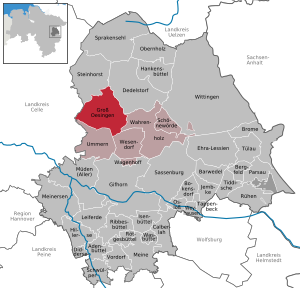
Groß Oesingen
Municipality in Lower Saxony, Germany
Distance: Approx. 7918 meters
Latitude and longitude: 52.65,10.48333333
Groß Oesingen is a municipality in the district of Gifhorn, in Lower Saxony, Germany. The Municipality Groß Oesingen includes the villages of Groß Oesingen, Klein Oesingen, Mahrenholz, Schmarloh, Texas and Zahrenholz.

Steinhorst, Lower Saxony
Municipality in Lower Saxony, Germany
Distance: Approx. 1908 meters
Latitude and longitude: 52.68333333,10.4
Steinhorst is a municipality in the district of Gifhorn, in Lower Saxony, Germany. Steinhorst includes the villages of Auermühle, Lüsche, Räderloh and Steinhorst.

Spechtshorn
Distance: Approx. 8531 meters
Latitude and longitude: 52.59976,10.38328
Spechtshorn is a village in the municipality of Hohne in the collective municipality of Lachendorf in Celle district, in the German state of Lower Saxony.
Schmarloh
Distance: Approx. 4580 meters
Latitude and longitude: 52.639248,10.404126
The Schmarloh is a ridge in the Südheide heath in the eastern part of the state of Lower Saxony in Germany, that lies between Groß Oesingen (Gifhorn district) and Lachendorf (Celle district) north of the Wiehe Stream. Its highest point is the 69-metre-high Jahrnsloh Berg, 2 km southwest of Groß Oesingen. It covers an area of 654 square kilometres (253 sq mi).

Schmalwasser
River in Germany
Distance: Approx. 3730 meters
Latitude and longitude: 52.7045,10.3447
Schmalwasser is a river of Lower Saxony, Germany on the southern edge of the Lüneburg Heath. The Schmalwasser rises near Blickwedel (a district of Sprakensehl), winds southwards, is joined from the left by the Räderbach and discharges into the Lutter in the village of Bargfeld. The story Die Wasserstraße by Arno Schmidt (1964) is about a walk up the Schmalwasser.
Köttelbeck
River in Germany
Distance: Approx. 3389 meters
Latitude and longitude: 52.7008,10.3447
Köttelbeck is a small river of Lower Saxony, Germany. It flows into the Lutter near Eldingen.
Aschenberg
Village of Eschede in Lower Saxony, Germany
Distance: Approx. 7731 meters
Latitude and longitude: 52.7,10.26666667
Aschenberg is a small village in the district of Celle, Lower Saxony, Germany. It is part of the Ortschaft Höfer within the municipality of Eschede.
Weather in this IP's area
broken clouds
-3 Celsius
-5 Celsius
-4 Celsius
-2 Celsius
1032 hPa
97 %
1032 hPa
1023 hPa
10000 meters
1.79 m/s
2.3 m/s
283 degree
57 %
