Country:
 Italy
ItalyRegion:
City:
Latitude and Longitude:
Time Zone:
Postal Code:
IP information under different IP Channel
ip-api
Country
Region
City
ASN
Time Zone
ISP
Blacklist
Proxy
Latitude
Longitude
Postal
Route
IPinfo
Country
Region
City
ASN
Time Zone
ISP
Blacklist
Proxy
Latitude
Longitude
Postal
Route
MaxMind
Country
Region
City
ASN
Time Zone
ISP
Blacklist
Proxy
Latitude
Longitude
Postal
Route
Luminati
Country
ITASN
Time Zone
Europe/Rome
ISP
SEEWEB s.r.l.
Latitude
Longitude
Postal
db-ip
Country
Region
City
ASN
Time Zone
ISP
Blacklist
Proxy
Latitude
Longitude
Postal
Route
ipdata
Country
Region
City
ASN
Time Zone
ISP
Blacklist
Proxy
Latitude
Longitude
Postal
Route
Popular places and events near this IP address

Abano Terme
Comune in Veneto, Italy
Distance: Approx. 4163 meters
Latitude and longitude: 45.36027778,11.79
Abano Terme (known as Abano Bagni until 1924) is a town and comune in the Province of Padua, in the Veneto region, Italy, on the eastern slope of the Euganean Hills; it is 10 kilometres (6 mi) southwest by rail from Padua. Abano Terme's population is 19,062 (2001) (in 1901 it was 4,556). The town's hot springs and mud baths are an important economic resource.

Prato della Valle
Square in Padova, Italy
Distance: Approx. 4480 meters
Latitude and longitude: 45.39833333,11.87583333
Prato della Valle (Prà de ła Vałe in Venetian) is a 90,000-square-meter elliptical square in Padua, Italy. It is the second largest square in Italy and one of the largest in Europe. Today, the square is a large space with a green island at the center, l'Isola Memmia, surrounded by a small canal bordered by two rings of statues.
Albignasego
Comune in Veneto, Italy
Distance: Approx. 2548 meters
Latitude and longitude: 45.35,11.86666667
Albignasego is a comune (municipality) in the Province of Padua in the Italian region Veneto, located about 35 kilometres (22 mi) west of Venice and about 7 kilometres (4.3 mi) south of Padua. As of 06/03/2021, it has a population of 26.006 inhabitants and an area of 21.0 square kilometres (8.1 sq mi). The municipality of Albignasego contains the main village and frazioni (hamlets) Carpanedo, Lion, Mandriola, S. Agostino, S. Giacomo.
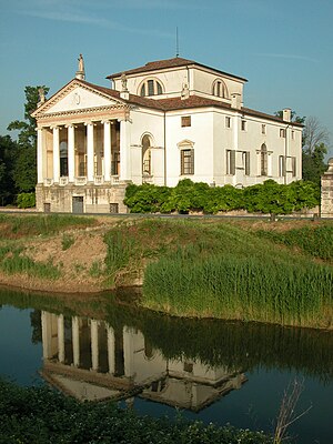
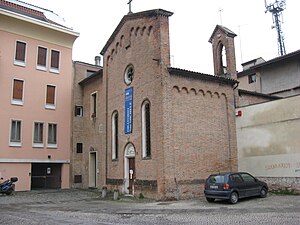
Villa Molin
Distance: Approx. 427 meters
Latitude and longitude: 45.3623,11.8397
Villa Molin is a patrician residence in the neighborhood of Mandria, in Ponte della Cagna, south of Padua, in the Veneto region of northern Italy. It was designed for Nicolò Molin, a Venetian noble, by Vincenzo Scamozzi and completed in 1597. It faces Mandriola, on the opposite side of the Canale di Battaglia.
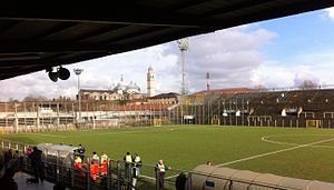
Stadio Silvio Appiani
Building in Padua, Italy
Distance: Approx. 4156 meters
Latitude and longitude: 45.395,11.87527778
Stadio Silvio Appiani is a multi-use stadium in Padua, Italy. It was initially used as the stadium of Calcio Padova matches. It was replaced by Stadio Euganeo in 1994.

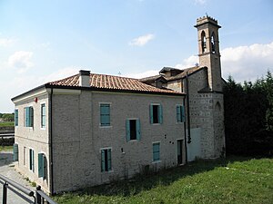
Villa Giusti
Villa outside of Padua, northern Italy
Distance: Approx. 594 meters
Latitude and longitude: 45.37083333,11.84277778
Villa Giusti or Villa Giusti del Giardino is a villa in Mandria, outside of Padua in Northern Italy. It is notable for being the site of the signing of the Armistice of Villa Giusti that ended the First World War on the Italian Front. Fully restored in the nineteenth century, the villa was owned at the time of the armistice by the Count Vettor Giusti del Giardino, of a Veneto noble family.

Abbey of Santa Giustina
10th-century Benedictine abbey in Padua, Italy
Distance: Approx. 4495 meters
Latitude and longitude: 45.39638889,11.87972222
The Abbey of Santa Giustina is a 10th-century Benedictine abbey complex located in front of the Prato della Valle in central Padua, region of Veneto, Italy. Adjacent to the former monastery is the basilica church of Santa Giustina, initially built in the 6th century, but whose present form derives from a 17th-century reconstruction.
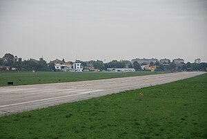
Padua Airport
Airport in Via Sorio
Distance: Approx. 3403 meters
Latitude and longitude: 45.39583333,11.84805556
Padua "Gino Allegri" Airport (Italian: Aeroporto di Padova "Gino Allegri") (ICAO: LIPU) is an airport serving Padua, Veneto, Italy.

Santa Croce, Padua
Distance: Approx. 3786 meters
Latitude and longitude: 45.393,11.8712
Santa Croce is a Roman Catholic church located on Corso Vittorio Emanuele 178 in Padua, Veneto region, Italy.

Madonna Addolorata al Torresino
Distance: Approx. 4514 meters
Latitude and longitude: 45.40041111,11.87206111
The Madonna Addolorata al Torresino, also called the Santa Maria del Pianto or Santa Maria del Torresino is a Roman Catholic parish church located in the city of Padua, region of Veneto, Italy.
San Michele Oratory
Building in Padua, Italy
Distance: Approx. 4492 meters
Latitude and longitude: 45.40133,11.86912
The San Michele Oratory or Oratory of San Michele (Italian - Oratorio di San Michele) is an oratory chapel in Padova, Italy. The interior is painted with a cycle of frescoes on the life of the Virgin Mary by Jacopo da Verona.

La Specola, Padua
Distance: Approx. 4527 meters
Latitude and longitude: 45.401879,11.868568
La Specola is a 14th-century tower, formerly part of a medieval castle, and converted in 1767 into an astronomical observatory (specula) in Padua, region of Veneto, Italy.
Weather in this IP's area
overcast clouds
14 Celsius
14 Celsius
14 Celsius
15 Celsius
1013 hPa
96 %
1013 hPa
1012 hPa
10000 meters
1.79 m/s
3.58 m/s
26 degree
93 %
07:19:45
18:40:09