Country:
Region:
City:
Latitude and Longitude:
Time Zone:
Postal Code:
IP information under different IP Channel
ip-api
Country
Region
City
ASN
Time Zone
ISP
Blacklist
Proxy
Latitude
Longitude
Postal
Route
Luminati
Country
ASN
Time Zone
Europe/Prague
ISP
Brnenske komunikace a.s.
Latitude
Longitude
Postal
IPinfo
Country
Region
City
ASN
Time Zone
ISP
Blacklist
Proxy
Latitude
Longitude
Postal
Route
db-ip
Country
Region
City
ASN
Time Zone
ISP
Blacklist
Proxy
Latitude
Longitude
Postal
Route
ipdata
Country
Region
City
ASN
Time Zone
ISP
Blacklist
Proxy
Latitude
Longitude
Postal
Route
Popular places and events near this IP address

Prague uprising
Partially successful 1945 rebellion in German-occupied Czechoslovakia
Distance: Approx. 421 meters
Latitude and longitude: 50.07861111,14.43444444
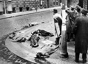
The Prague uprising (Czech: Pražské povstání) was a partially successful attempt by the Czech resistance movement to liberate the city of Prague from German occupation in May 1945, during the end of World War II. The preceding six years of occupation had fuelled anti-German sentiment and the rapid advance of Allied forces from the Red Army and the United States Army offered the resistance a chance of success. On 5 May 1945, during the end of World War II in Europe, occupying German forces in Bohemia and Moravia were spontaneously attacked by civilians in an uprising, with Czech resistance leaders emerging from hiding to join them. The Russian Liberation Army (ROA), a collaborationist formation of ethnic Russians, defected and supported the insurgents.

Prague 2
Municipal district in Prague, Czechia
Distance: Approx. 385 meters
Latitude and longitude: 50.07416667,14.44277778
Prague 2, formally the Prague 2 Municipal District (Městská čast Praha 2), is a second-tier municipality in Prague. It is co-extensive with the national administrative district (správní obvod) of the same name. As of the end of 2004, 48,918 people lived in 34,689 homes in the district.

Czech Radio
Public broadcaster of the Czech Republic
Distance: Approx. 421 meters
Latitude and longitude: 50.07861111,14.43444444
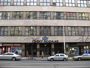
Český rozhlas (ČRo Lit.: Czech Radio) is the public radio broadcaster of the Czech Republic operating continuously since 1923. It is the oldest radio broadcaster in continental Europe and the second oldest in Europe after the BBC. Český rozhlas was established in 1992 by the Czech Radio Act, which sets out the framework for its operation and financing. It acts as the successor to the previous state-owned Czechoslovak Radio which ceased to exist by 1992.

Náměstí Míru (Prague Metro)
Prague metro station
Distance: Approx. 20 meters
Latitude and longitude: 50.0753325,14.43769
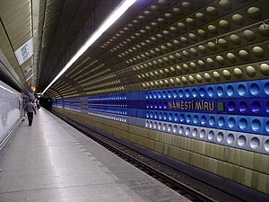
Náměstí Míru (Czech pronunciation: [ˈnaːmɲɛsciː ˈmiːru], English: Peace Square) is a Prague Metro station on Line A. It is located in Vinohrady district under Korunní Street and has one exit through an escalator tunnel with a sub-surface vestibule under the plaza of the same name. The exit of the metro station is in the immediate vicinity of the Church of St. Ludmila and Vinohrady Theatre.

Lauder Schools of Prague
Distance: Approx. 238 meters
Latitude and longitude: 50.07396111,14.43548889
The Lauder Schools of Prague (Czech: Lauderovy školy v Praze) are the only Jewish schools in Prague and in the entire Czech Republic. The schools consists of an elementary school called The Lauder Gur Arje Jewish Day School and a secondary school called The Lauder Or Chadaš Jewish Community High School. The names of the schools refer to an important figure of the Jewish Ghetto in Prague, Rabbi Judah Loew ben Bezalel, who was also known as the Maharal of Prague and Rabbi Loew.

Battle for Czech Radio
Distance: Approx. 421 meters
Latitude and longitude: 50.07861111,14.43444444
An illicit broadcast from the radio studio in Prague helped spark the Prague uprising during the final days of World War II, but German counterattacks led to a pitched battle breaking out. The conflict became known as the Battle for Czech Radio (Czech: Boj o Český rozhlas). By controlling the radio, the Czech resistance was able to inform and inspire the people of Prague to effective action during the Prague uprising.
CZ.NIC
Czech domain registration association
Distance: Approx. 290 meters
Latitude and longitude: 50.0729,14.4377
CZ.NIC is a Czech interest association of legal persons established by leading Internet service providers in 1998. The main activity of the association is administration of domain names .cz and 0.2.4.e164.arpa (ENUM), administration of .cz top-level domains and education in the area of domain names. Currently, the employees of the association are intensively working on expanding the DNSSEC technology, developing the domain administration system and mojeID service and promoting new technologies and projects beneficial to the Internet infrastructure in the Czech Republic.

University of New York in Prague
Distance: Approx. 532 meters
Latitude and longitude: 50.07627222,14.43045556
The University of New York in Prague (UNYP) is a private higher education institution in Prague, Czech Republic. It was established in 1998 in cooperation with the State University of New York at New Paltz and Empire State University, both part of the State University of New York (SUNY). UNYP was recognized by the Czech Ministry of Education, Youth and Sports in 2001 on the basis of accreditation of its study programs in Business Administration and International European Relations.
Vinohrady Theatre
Theatre in Prague, Czechia
Distance: Approx. 107 meters
Latitude and longitude: 50.07638889,14.43722222
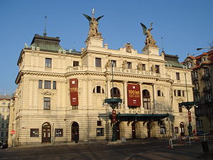
Vinohrady Theatre (Czech: Divadlo na Vinohradech) is a theatre in Vinohrady, Prague. Construction began on February 27, 1905. It served as the Theatre of the Czechoslovak Army from autumn 1950 to January 1966.
Prague City University
Distance: Approx. 374 meters
Latitude and longitude: 50.07855556,14.43996667
Prague City University is an English-language private university in the Vinohrady district of Prague, Czech Republic, founded in 2004. Formerly known as Prague College, the university adopted its current name in 2021. The university has two campuses, both located in the Prague 1 district.

Basilica of St. Ludmila
Roman Catholic basilica in Prague, Czechia
Distance: Approx. 41 meters
Latitude and longitude: 50.075475,14.43723056
The Basilica of St. Ludmila (Czech: Bazilika svaté Ludmily) is a neo-Gothic Catholic church at Náměstí Míru (Peace Square) in Prague's Vinohrady, built on plans of Josef Mocker in 1888–1892. It is named in honor of St.

Transgas (building)
Demolished structure in Prague
Distance: Approx. 463 meters
Latitude and longitude: 50.07833333,14.43305556
Transgas was a high tech building with brutalist elements in the center of Prague, Czech Republic. It was built in 1978 and demolished in 2019. It consisted of a cubic part, which was dark grey.
Weather in this IP's area
broken clouds
3 Celsius
0 Celsius
1 Celsius
4 Celsius
1030 hPa
96 %
1030 hPa
998 hPa
6000 meters
2.06 m/s
200 degree
75 %
06:59:10
16:32:30

