91.201.220.131 - IP Lookup: Free IP Address Lookup, Postal Code Lookup, IP Location Lookup, IP ASN, Public IP
Country:
Region:
City:
Location:
Time Zone:
Postal Code:
IP information under different IP Channel
ip-api
Country
Region
City
ASN
Time Zone
ISP
Blacklist
Proxy
Latitude
Longitude
Postal
Route
Luminati
Country
ASN
Time Zone
Europe/Bucharest
ISP
EVOBITS Information Technology SRL
Latitude
Longitude
Postal
IPinfo
Country
Region
City
ASN
Time Zone
ISP
Blacklist
Proxy
Latitude
Longitude
Postal
Route
IP2Location
91.201.220.131Country
Region
caras-severin
City
resita
Time Zone
Europe/Bucharest
ISP
Language
User-Agent
Latitude
Longitude
Postal
db-ip
Country
Region
City
ASN
Time Zone
ISP
Blacklist
Proxy
Latitude
Longitude
Postal
Route
ipdata
Country
Region
City
ASN
Time Zone
ISP
Blacklist
Proxy
Latitude
Longitude
Postal
Route
Popular places and events near this IP address

Reșița
Municipality in Caraș-Severin, Romania
Distance: Approx. 123 meters
Latitude and longitude: 45.3,21.89027778
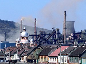
Reșița (pronounced [ˈreʃit͡sa] ; German: Reschitz; Hungarian: Resicabánya; Croatian: Ričica; Czech: Rešice; Serbian: Решица/Rešica; Turkish: Reşçe) is a city in western Romania and the capital of Caraș-Severin County. It is located in the Banat region. The city had a population of 58,393 in 2021.

Ocna de Fier
Commune in Caraș-Severin, Romania
Distance: Approx. 9947 meters
Latitude and longitude: 45.34194444,21.77638889
Ocna de Fier (Hungarian: Vaskő, German: Eisenstein) is a commune in Caraș-Severin County, in the Banat region of southwestern Romania. It is composed of a single village, Ocna de Fier.

Lupac
Commune in Caraș-Severin, Romania
Distance: Approx. 6004 meters
Latitude and longitude: 45.28333333,21.81666667
Lupac (Romanian: Lupac; Croatian: Lupak; Hungarian: Kiskrassó) is a commune in Caraș-Severin County, Banat, Romania. It is composed of four villages: Clocotici (Klokotič; Krassócsörgő), Lupac, Rafnic (Ravnik; Kengyeltó), and Vodnic (Vodnik; Vizes).
Sodol
River in Caraș-Severin County, Romania
Distance: Approx. 3587 meters
Latitude and longitude: 45.2944,21.9341
The Sodol is a left tributary of the river Bârzava in Romania. It discharges into the Bârzava in the city Reșița. Its length is 6 km (3.7 mi) and its basin size is 24 km2 (9.3 sq mi).
Bârzăvița
River in Caraș-Severin County, Romania
Distance: Approx. 3486 meters
Latitude and longitude: 45.3277,21.8664
The Bârzăvița is a left tributary of the river Bârzava in Romania. It flows into the Bârzava in the city Reșița. Its length is 7 km (4.3 mi) and its basin size is 12 km2 (4.6 sq mi).
Doman (river)
River in Caraș-Severin County, Romania
Distance: Approx. 1216 meters
Latitude and longitude: 45.2899,21.8882
The Doman (also: Budinic) is a left tributary of the river Bârzava in Romania. It flows into the Bârzava in the city Reșița. Its length is 5 km (3.1 mi) and its basin size is 16 km2 (6.2 sq mi).
Țerova
River in Caraș-Severin County, Romania
Distance: Approx. 1543 meters
Latitude and longitude: 45.314,21.8832
The Țerova is a right tributary of the river Bârzava in Romania. It discharges into the Bârzava in the city Reșița. Its length is 15 km (9.3 mi) and its basin size is 39 km2 (15 sq mi).

Reșița Works
Distance: Approx. 1259 meters
Latitude and longitude: 45.295,21.903
The Reșița Works are two companies, TMK Reșița and UCM Reșița, located in Reșița, in the Banat region of Romania. Founded in 1771 and operating under a single structure until 1948 and then from 1954 to 1962, during the Communist era they were known respectively as the Reșița Steel Works (Combinatul Siderurgic Reșița) and as the Reșița Machine Building Plant (Uzina Constructoare de Mașini Reșița), the latter renamed in 1973 as the Reșița Machine Building Enterprise (Întreprinderea de Construcții de Mașini Reșița). They have played a crucial role in the industrial development both of the region and of Romania as a whole, and their evolution has been largely synonymous with that of their host city.

Saint Mary of the Snows Church, Reșița
Catholic church
Distance: Approx. 1159 meters
Latitude and longitude: 45.2948,21.9013
Saint Mary of the Snows Church, Reșița (Latin: Ecclesia in hon. Beatae Mariae Virginis ad Nives dedicata; Romanian: Biserica romano-catolică Maria Zăpezii; German: Römisch Katholische Kirche Maria Schnee; Hungarian: Havas Boldogasszony-templom) is the first Catholic church of Reșița, Romania. Situated in the old part of the city, it is flanked by the steel works and is closed in by a bridge-tunnel that helps intersection of the public road with industrial activities ways of the steel works.

Reșița Synagogue
Neolog synagogue in Reșița, Romania
Distance: Approx. 1166 meters
Latitude and longitude: 45.292767,21.89875
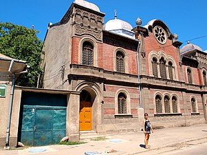
The Reșița Synagogue (Romanian: Sinagoga din Reșița) is a Neolog Jewish congregation and synagogue, located at 8 Mihai Viteazu Street in Reșița, in the Caraș-Severin County of Romania. Designed in the Romanesque Revival style, the synagogue was completed in 1880. The synagogue is included on the National Register of Historic Monuments in Romania.
Weather in this IP's area
scattered clouds
1 Celsius
1 Celsius
1 Celsius
1 Celsius
1036 hPa
93 %
1036 hPa
1001 hPa
10000 meters
0.94 m/s
0.93 m/s
161 degree
25 %