91.201.111.129 - IP Lookup: Free IP Address Lookup, Postal Code Lookup, IP Location Lookup, IP ASN, Public IP
Country:
Region:
City:
Location:
Time Zone:
Postal Code:
IP information under different IP Channel
ip-api
Country
Region
City
ASN
Time Zone
ISP
Blacklist
Proxy
Latitude
Longitude
Postal
Route
Luminati
Country
Region
09
City
luhansk
ASN
Time Zone
Europe/Kyiv
ISP
Lugansk Telephone Company
Latitude
Longitude
Postal
IPinfo
Country
Region
City
ASN
Time Zone
ISP
Blacklist
Proxy
Latitude
Longitude
Postal
Route
IP2Location
91.201.111.129Country
Region
yaroslavskaya oblast'
City
rostov
Time Zone
Europe/Moscow
ISP
Language
User-Agent
Latitude
Longitude
Postal
db-ip
Country
Region
City
ASN
Time Zone
ISP
Blacklist
Proxy
Latitude
Longitude
Postal
Route
ipdata
Country
Region
City
ASN
Time Zone
ISP
Blacklist
Proxy
Latitude
Longitude
Postal
Route
Popular places and events near this IP address

Rostov, Yaroslavl Oblast
Town in Yaroslavl Oblast, Russia
Distance: Approx. 929 meters
Latitude and longitude: 57.18333333,39.41666667
Rostov (Russian: Росто́в, IPA: [rɐˈstof]) is a town in Yaroslavl Oblast, Russia, one of the oldest in the country and a tourist center of the Golden Ring. It is located on the shores of Lake Nero, 202 kilometers (126 mi) northeast of Moscow. Population: 30,406 (2021 Census); 31,792 (2010 Census); 34,141 (2002 Census); 35,707 (1989 Soviet census).

Lake Nero
Body of water in Yaroslavl Oblast, Russia
Distance: Approx. 3303 meters
Latitude and longitude: 57.16472222,39.43666667
Lake Nero (Russian: Не́ро) is a shallow, highly eutrophic lake in Yaroslavl Oblast, Russia. The lake has an area of 54.4 km2, a maximum length of 13 km, width 8 km and depth 3.6 m. The bottom of the lake is covered with thick layer of silt sapropel (a sort of ooze used as fertilizer and for other purposes).

Rostov-Yaroslavsky railway station
Railway station
Distance: Approx. 811 meters
Latitude and longitude: 57.19805556,39.40722222
Rostov-Yaroslavsky (until 1904 was known as Rostov) is the passenger railway station in Rostov (Yaroslavl Oblast, Russia) and a stop along the Trans-Siberian Railway.
Ustye (river)
River in Russia
Distance: Approx. 8825 meters
Latitude and longitude: 57.2454,39.5199
The Ustye (Russian: Устье) is a river in Yaroslavl Oblast in Russia, a left tributary of the river Kotorosl (Volga's basin). The river is 153 kilometres (95 mi) long, and the area of its drainage basin is 2,530 square kilometres (980 sq mi). The Ustye freezes up in November and remains icebound until the end March to early April.
Spaso-Yakovlevsky Monastery
Eastern Orthodox monastery
Distance: Approx. 2464 meters
Latitude and longitude: 57.173,39.39
Monastery of St. Jacob Saviour (Russian: Спасо-Яковлевский монастырь, romanized: Spaso-Yakovlevsky) is an Eastern Orthodox monastery situated to the left from the Rostov kremlin on the Rostov's outskirts. The monastery was founded in 1389 by St Iakov of Rostov, who was banished from his town for sparing a woman sentenced to death.

Rostovsky District
District in Yaroslavl Oblast, Russia
Distance: Approx. 929 meters
Latitude and longitude: 57.18333333,39.41666667
Rostovsky District (Russian: Росто́вский райо́н) is an administrative and municipal district (raion), one of the seventeen in Yaroslavl Oblast, Russia. It is located in the southeast of the oblast. The area of the district is 2,081.82 square kilometers (803.80 sq mi).
Ishnya
Urban-type settlement in Yaroslavl Oblast, Russia
Distance: Approx. 3880 meters
Latitude and longitude: 57.1936,39.3485
Ishnya (Russian: Ишня) is an urban locality (an urban-type settlement) in Rostovsky District of Yaroslavl Oblast, Russia. Population: 3,127 (2010 Census); 3,368 (2002 Census); 3,889 (1989 Soviet census).

Ishnya Church
Distance: Approx. 3742 meters
Latitude and longitude: 57.18027778,39.35416667
The Church of St. John the Theologian on the Ishnya River (церковь Иоанна Богослова на Ишне) is situated several miles west of Rostov, close to the Northern Mainline. It was built of wood in 1687 as a filial church of the Avraamiev Monastery marking the supposed place where the monastery's founder had met St.

Shurskol
Selo in Yaroslavl Oblast, Russia
Distance: Approx. 8565 meters
Latitude and longitude: 57.1531,39.2896
Shurskol (Russian: Шу́рскол) is a village (selo) in Rostovsky District of Yaroslavl Oblast, Russia. It is located 189 kilometres (117 mi) from Moscow, 59 kilometres (37 mi) from Yaroslavl, 5 kilometres (3.1 mi) from Rostov, 4 kilometres (2.5 mi) from the Moscow-Arkhangelsk federal highway (part of European route E115), and 2 kilometres (1.2 mi) from the Moscow-Yaroslavl railway line. The nearest railway station, Rostov-Yaroslavsky, is 9 km from the village.
Rostov Kremlin
Historic site in Yaroslavl Oblast, Russia
Distance: Approx. 1152 meters
Latitude and longitude: 57.19944444,39.42472222
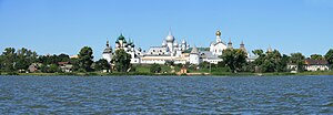
The Rostov Kremlin (Russian Ростовский кремль) is an architectural ensemble of four complexes, built during the 16th and 17th centuries in Rostov, Yaroslavl Oblast, Russia. The Kremlin is located in the center of Rostov. According to its original purpose, the ensemble of the Rostov Kremlin was the residence of the Metropolitans, Metropolitan Bishop, of the Rostov diocese.

Rostov Kremlin (museum-reserve)
Museum in Rostov, Yaroslavl Oblast, Russia
Distance: Approx. 806 meters
Latitude and longitude: 57.18444444,39.41638889
Rostov Kremlin (in Russian: Федеральное государственное учреждение культуры Государственный музей-заповедник «Ростовский кремль») - is a National museum-reserve situated in Rostov, Yaroslavl Oblast, Russian Federation. Museum-reserve preserves the architectural ensemble of the Rostov Kremlin (except for the Assumption Cathedral and Assumption Cathedral Belfry), Church of St. John the Evangelist (1687) on Ishnya river, and has got different branches within the Rostov municipal district.
Weather in this IP's area
overcast clouds
1 Celsius
-4 Celsius
1 Celsius
1 Celsius
1000 hPa
100 %
1000 hPa
985 hPa
29 meters
5.25 m/s
11.49 m/s
219 degree
100 %


