91.198.238.118 - IP Lookup: Free IP Address Lookup, Postal Code Lookup, IP Location Lookup, IP ASN, Public IP
Country:
 Germany
Region:
City:
Location:
Time Zone:
Postal Code:
ISP:
ASN:
language:
User-Agent:
Proxy IP:
Blacklist:
IP information under different IP Channel
ip-api
Country
Region
City
ASN
Time Zone
ISP
Blacklist
Proxy
Latitude
Longitude
Postal
Route
db-ip
Country
Region
City
ASN
Time Zone
ISP
Blacklist
Proxy
Latitude
Longitude
Postal
Route
IPinfo
Country
Region
City
ASN
Time Zone
ISP
Blacklist
Proxy
Latitude
Longitude
Postal
Route
IP2Location
91.198.238.118Country
deRegion
baden-wurttemberg
City
rastatt
Time Zone
Europe/Berlin
ISP
Language
User-Agent
Latitude
Longitude
Postal
ipdata
Country
Region
City
ASN
Time Zone
ISP
Blacklist
Proxy
Latitude
Longitude
Postal
Route
Popular places and events near this IP address

Battle of Rastatt (1796)
Battle of the War of the First Coalition
Distance: Approx. 1179 meters
Latitude and longitude: 48.85,8.2
The Battle of Rastatt (5 July 1796) saw part of a Republican French army under Jean Victor Marie Moreau clash with elements of the Habsburg army under Maximilian Anton Karl, Count Baillet de Latour which were defending the line of the Murg River. Leading a wing of Moreau's army, Louis Desaix attacked the Austrians and drove them back to the Alb River in the War of the First Coalition action. Rastatt is a city in the state of Baden-Württemberg in Germany, located 89 kilometers (55 mi) south of Mannheim and 94 kilometres (58 mi) west of Stuttgart.

Rastatt
Town in Baden-Württemberg, Germany
Distance: Approx. 1179 meters
Latitude and longitude: 48.85,8.2
Rastatt (German: [ˈʁaʃtat]) is a town with a Baroque core, District of Rastatt, Baden-Württemberg, Germany. It is located in the Upper Rhine Plain on the Murg river, 6 km (3.7 mi) above its junction with the Rhine and has a population of around 51,000 (2022). Rastatt was an important place of the War of the Spanish Succession (Treaty of Rastatt) and the Revolutions of 1848 in the German states.

Ötigheim
Municipality in Baden-Württemberg, Germany
Distance: Approx. 4126 meters
Latitude and longitude: 48.89111111,8.23638889
Ötigheim (Low Alemannic: Etje) is a town in the district of Rastatt in Baden-Württemberg in Germany. Its immediate neighbours are the towns of Bietigheim and Steinmauern.

Steinmauern
Municipality in Baden-Württemberg, Germany
Distance: Approx. 4720 meters
Latitude and longitude: 48.90027778,8.19861111
Steinmauern is a town in the district of Rastatt in Baden-Württemberg in Germany. It falls under the administrative jurisdiction of Karlsruhe.

Schloss Favorite (Rastatt)
Schloss in Baden-Württemberg, Germany
Distance: Approx. 4612 meters
Latitude and longitude: 48.82222222,8.24
Schloss Favorite is a schloss on the outskirts of Rastatt-Förch in Baden-Württemberg, Germany.

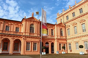
Schloss Rastatt
Baroque schloss in Rastatt, Germany
Distance: Approx. 299 meters
Latitude and longitude: 48.85888889,8.20555556
Schloss Rastatt, also known as Residenzschloss Rastatt, is a Baroque schloss in Rastatt, Germany. The palace and the garden were built between 1700 and 1707 by the Italian architect Domenico Egidio Rossi for Margrave Louis William of Baden-Baden. Visitors can tour the restored Baroque interior and gardens.

Rastatt station
Railway station in Rastatt, Germany
Distance: Approx. 493 meters
Latitude and longitude: 48.86055556,8.21555556
Rastatt station is the main passenger station in the town of Rastatt in the German state of Baden-Württemberg. It is an important station for the Karlsruhe Stadtbahn, being served by four of its lines, which are operated by the Albtal-Verkehrs-Gesellschaft ("Alb Valley Transport Company", AVG). In addition, it is served by regional and long-distance trains operated by Deutsche Bahn.
Wehrgeschichtliches Museum Rastatt
Museum in Germany
Distance: Approx. 320 meters
Latitude and longitude: 48.85805556,8.20527778
The Wehrgeschichtliches Museum Rastatt (in English: Military History Museum) or WGM is a military historical museum in Rastatt, Germany. Since 1956, it has been housed in the south wing of the Schloss Rastatt. The museum was originally found in 1934 as the Badisches Armeemuseum.
Erinnerungsstätte für die Freiheitsbewegungen in der deutschen Geschichte
Museum in Rastatt, Germany
Distance: Approx. 381 meters
Latitude and longitude: 48.8586,8.2044
The Erinnerungsstätte für die Freiheitsbewegungen in der deutschen Geschichte (literally Memorial site for freedom movements in German history) is a museum and memorial to free democratic traditions in Germany. It is housed in the Schloss Rastatt (chosen due to the town of Rastatt being a key site in the Baden Revolution and the Revolutions of 1848 in the German states) and known as the Freiheitsmuseum (Freedom Museum) for short. It was opened on 26 June 1974 by president Gustav Heinemann.

Oos (river)
River in Germany
Distance: Approx. 381 meters
Latitude and longitude: 48.8569,8.2142
The Oos (OHS), also called the Oosbach, is a river of Baden-Württemberg, Germany. It starts in the Northern Black Forest, flows through Baden-Baden, and ends in the Murg in Rastatt.

Freilichtbühne Ötigheim
Theatre in Ötigheim, Baden-Württemberg, Germany
Distance: Approx. 3266 meters
Latitude and longitude: 48.88388889,8.23194444
Freilichtbühne Ötigheim is an open-air theatre in Ötigheim, Baden-Württemberg, Germany.

Rastatt Fortress
Distance: Approx. 72 meters
Latitude and longitude: 48.85833333,8.21055556
Rastatt Fortress (German: Bundesfestung Rastatt) was built from 1842 to 1852. The construction of this federal fortress was one of the few projects that the German Confederation was able to complete. The fortress site covered the Baden town of Rastatt and, in 1849, played an important role during the Baden Revolution.
Weather in this IP's area
moderate rain
9 Celsius
8 Celsius
7 Celsius
9 Celsius
1018 hPa
94 %
1018 hPa
995 hPa
3500 meters
1.54 m/s
280 degree
100 %