Country:
 Ukraine
Region:
City:
Latitude and Longitude:
Time Zone:
Postal Code:
IP information under different IP Channel
ip-api
Country
Region
City
ASN
Time Zone
ISP
Blacklist
Proxy
Latitude
Longitude
Postal
Route
IPinfo
Country
Region
City
ASN
Time Zone
ISP
Blacklist
Proxy
Latitude
Longitude
Postal
Route
MaxMind
Country
Region
City
ASN
Time Zone
ISP
Blacklist
Proxy
Latitude
Longitude
Postal
Route
Luminati
Country
UAASN
Time Zone
Europe/Kyiv
ISP
New Information Systems PP
Latitude
Longitude
Postal
db-ip
Country
Region
City
ASN
Time Zone
ISP
Blacklist
Proxy
Latitude
Longitude
Postal
Route
ipdata
Country
Region
City
ASN
Time Zone
ISP
Blacklist
Proxy
Latitude
Longitude
Postal
Route
Popular places and events near this IP address

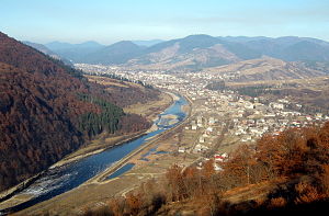
Khust
City in Zakarpattia Oblast, Ukraine
Distance: Approx. 879 meters
Latitude and longitude: 48.18138889,23.29777778
Khust (Ukrainian: Хуст, Russian: Хуст, Hungarian: Huszt, German: Chust, Romanian: Hust, Yiddish: כוסט (Khist)) is a city located on the Khustets River in Zakarpattia Oblast, western Ukraine. It is near the сonfluence of the Tisa and Rika Rivers. It serves as the administrative center of Khust Raion.
Rika (river)
River in Ukraine
Distance: Approx. 2592 meters
Latitude and longitude: 48.1761,23.2625
The Rika (Ukrainian: Ріка) is a right tributary of the river Tisza in the Zakarpattia Oblast, western Ukraine. Its basin covers an area of 1,145 km2 (442 sq mi).: 23 It rises in the Eastern Carpathians. It flows through the town Mizhhirya and discharges into the Tisza near Khust.

Veliatyno
Village in Zakarpattia Oblast, Ukraine
Distance: Approx. 7234 meters
Latitude and longitude: 48.10944444,23.31361111
Veliatynо (Ukrainian: Велятино; Hungarian: Veléte) is a village in the Khust Raion of Zakarpattia Oblast, Ukraine. As of 2001, its population was 4,576. It was formerly named Veliatyn, until 2018.

Khust Castle
Distance: Approx. 681 meters
Latitude and longitude: 48.16805556,23.30138889
The Khust Castle (Ukrainian: Хустський замок; Hungarian: Huszti vár) is an abandoned castle located in the city of Khust in Zakarpattia Oblast (province) in western Ukraine. The former Hungarian castle lies on a 150-meter high mountain near the center of the city. The construction of the castle is believed to have started around 1090, during the reign of the Hungarian King St.
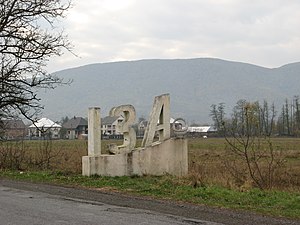
Iza, Ukraine
Village in Zakarpattia Oblast, Ukraine
Distance: Approx. 5064 meters
Latitude and longitude: 48.21388889,23.32861111
Iza (Ukrainian: Іза; Rusyn: Иза; Hebrew: איזה; German: Isa; Russian: Иза) is a village in the Khust Raion of Zakarpattia Oblast in western Ukraine. It is located between two mountain ranges, on the left bank of the river, 5 km from the Khust city center and railway station. The population is 5,800 (2018).
Sokyrnytsia
Village in Zakarpattia Oblast, Ukraine
Distance: Approx. 9388 meters
Latitude and longitude: 48.12416667,23.39972222
Sokyrnytsia (Ukrainian: Сокирниця, Romanian: Seclenț, Hungarian: Szeklence) is a village located on the Khust-Synevyr highway near the H09 (Mukachevo-Ivano-Frankivsk-Rohatyn-Lviv) motorway, 10 km from the district center, Khust. It is a village in Khust Raion of Zakarpattia Oblast (province) of western Ukraine. The first mention in the documents dates back to 1389.

Valley of Narcissi
Nature reserve in Zakarpattia Oblast, Ukraine
Distance: Approx. 3936 meters
Latitude and longitude: 48.17833333,23.34972222
The Valley of Narcissi (Ukrainian: Долина нарцисів) is a nature reserve in Kireshi, Zakarpattia Oblast, Ukraine. Part of the Carpathian Biosphere Reserve, it has an area of 256 ha (630 acres).
Khust urban hromada
Urban hromada in Zakarpattia Oblast, Ukraine
Distance: Approx. 879 meters
Latitude and longitude: 48.18138889,23.29777778
Khust urban territorial hromada (Ukrainian: Хустська міська територіальна громада, romanized: Khustska miska terytorialna hromada) is one of the hromadas of Ukraine, located in the country's western Zakarpattia Oblast. Its administrative centre is the city of Khust. Khust urban hromada has a total area of 402.3 km2 (155.3 sq mi), and also has a population of 80,858 (as of 2023).

Karpaty Stadium
Stadium in Khust, Ukraine
Distance: Approx. 1465 meters
Latitude and longitude: 48.17822222,23.27877778
Karpaty Stadium (Ukrainian: Стадіон Карпати) is a football stadium in Khust, Ukraine. It is the home stadium of FC Khust. Stadium was opened in 1982 as Avanhard and holds 5,200 spectators.
Weather in this IP's area
clear sky
11 Celsius
10 Celsius
11 Celsius
11 Celsius
1024 hPa
58 %
1024 hPa
1004 hPa
10000 meters
1.48 m/s
1.38 m/s
63 degree
07:50:52
18:32:37