Country:
 Ireland
Region:
City:
Latitude and Longitude:
Time Zone:
Postal Code:
IP information under different IP Channel
ip-api
Country
Region
City
ASN
Time Zone
ISP
Blacklist
Proxy
Latitude
Longitude
Postal
Route
IPinfo
Country
Region
City
ASN
Time Zone
ISP
Blacklist
Proxy
Latitude
Longitude
Postal
Route
MaxMind
Country
Region
City
ASN
Time Zone
ISP
Blacklist
Proxy
Latitude
Longitude
Postal
Route
Luminati
Country
IEASN
Time Zone
Europe/Dublin
ISP
HEAnet CLG
Latitude
Longitude
Postal
db-ip
Country
Region
City
ASN
Time Zone
ISP
Blacklist
Proxy
Latitude
Longitude
Postal
Route
ipdata
Country
Region
City
ASN
Time Zone
ISP
Blacklist
Proxy
Latitude
Longitude
Postal
Route
Popular places and events near this IP address

International Financial Services Centre, Dublin
Financial centre in Dublin, Ireland
Distance: Approx. 40 meters
Latitude and longitude: 53.34944444,-6.24722222
The International Financial Services Centre (IFSC) is an area of central Dublin and part of the CBD established in the 1980s as an urban regeneration area and special economic zone (SEZ) on the derelict state-owned former port authority lands of the reclaimed North Wall and George's Dock areas of the Dublin Docklands. The term has become a metonym for the Irish financial services industry as well as being used as an address and still being classified as an SEZ. It officially began in 1987 as an SEZ on an 11-hectare (27-acre) docklands site in central Dublin, with EU approval to apply a 10% corporate tax rate for "designated financial services activities". Before the expiry of this EU approval in 2005, the Irish Government legislated to effectively have a national flat rate by reducing the overall Irish corporate tax rate from 32% to 12.5% which was introduced in 2003.
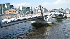
Seán O'Casey Bridge
Bridge over the River Liffey in Ireland
Distance: Approx. 271 meters
Latitude and longitude: 53.3473,-6.248
Seán O'Casey Bridge (Irish: Droichead Sheáin Uí Chathasaigh) is a pedestrian swingbridge spanning the River Liffey in Dublin, Ireland, joining City Quay in the Grand Canal Docks area to North Wall Quay and the IFSC. Designed by architect Cyril O'Neill and O'Connor Sutton Cronin Consulting Engineers (for which they won an Institution of Structural Engineers Award for Pedestrian Bridges in 2006), the bridge was built in 2005 as part of a large-scale urban renewal scheme under the Dublin Docklands Development Authority to link the north and south quays and rejuvenate both. The swing bridge spans approximately 100 metres and has two balanced cantilever arms that swing open to permit boats to pass upriver. Around 2010 the remote control that operates the swing bridge was misplaced, and the bridge was unable to be opened until the control system was reprogrammed in 2014.

Jeanie Johnston
Ship; replica of a three-masted barque from 1847
Distance: Approx. 222 meters
Latitude and longitude: 53.34771944,-6.24558611
Jeanie Johnston is a replica of a three-masted barque that was originally built in Quebec, Canada, in 1847 by the Scottish-born shipbuilder John Munn. The replica Jeanie Johnston performs a number of functions: it is an ocean-going sail training vessel at sea, and in port, it converts into a living history museum on 19th century emigration and, in the evenings, is used as a corporate event venue.
National College of Ireland
Third-level institution in Dublin, Ireland
Distance: Approx. 243 meters
Latitude and longitude: 53.348896,-6.24322
National College of Ireland (NCI) (Coláiste Náisiúnta na hÉireann (CNÉ) in Irish) is a not-for-profit, state-aided third-level education institution in Dublin. It was founded in 1951 as a joint venture between the Jesuits in Ireland and Irish trade unions, and was originally named the Catholic Workers College, Dublin. It is now an independent higher education institution, offering full and part-time courses from undergraduate to postgraduate level, in the areas of business, computing, psychology and education.

George's Dock, Dublin
Georgian canal dock in Dublin, Ireland
Distance: Approx. 61 meters
Latitude and longitude: 53.3496,-6.2476
George's Dock (Irish: Duga Sheoirse) is a Georgian dock in the Docklands area of Dublin forming part of the International Financial Services Centre.

Mayor Square
Distance: Approx. 229 meters
Latitude and longitude: 53.3492,-6.2433
Mayor Square is in Dublin, in the Docklands area. The National College of Ireland is based there. Since December 2009, the Mayor Square - NCI Luas stop has been served by the Luas Red Line tram which runs from Tallaght or Saggart to Connolly and the Docklands branch line from Busáras to The Point (3Arena).

Amiens Street
Street in Dublin, Ireland named after John Stratford
Distance: Approx. 284 meters
Latitude and longitude: 53.35138889,-6.24972222
Amiens Street (Irish: Sráid Amiens) is a road in Dublin, Ireland, that runs from Memorial Road to North Strand.

EPIC The Irish Emigration Museum
Museum in Dublin
Distance: Approx. 199 meters
Latitude and longitude: 53.348,-6.248
EPIC The Irish Emigration Museum, located in Dublin's Docklands, covers the history of the Irish diaspora and emigration to other countries. It was designed by the London-based design firm Event Communications, and was voted as "Europe's Leading Tourist Attraction" at the 2019, 2020 and 2021 World Travel Awards.

CHQ Building
Industrial building in Dublin, Ireland
Distance: Approx. 125 meters
Latitude and longitude: 53.3488,-6.248
The CHQ Building, formerly known as Stack A, is an industrial building in Dublin, Ireland. CHQ stands for "Custom House Quay", named for the nearby Custom House. Known as the Tobacco Store to dockworkers, it was built in 1820 to store cargos of tobacco, tea, wine and spirits and later grain and flour.

Famine Memorial (Dublin)
Monument in Customs House Quay, Dublin, Ireland
Distance: Approx. 283 meters
Latitude and longitude: 53.348044,-6.250056
The Famine Memorial, officially titled Famine, is a memorial in Dublin, Ireland. The memorial, which stands on Customs House Quay, is in remembrance of the Great Famine (1845-1849), which saw the population of the country halved through death and emigration.

Mayor Square - NCI Luas stop
Tram stop in Dublin, Ireland
Distance: Approx. 223 meters
Latitude and longitude: 53.349246,-6.243376
Mayor Square - NCI (Irish: Cearnóg an Mhéara - CNÉ) is a stop on the Luas light-rail tram system in Dublin, Ireland. It opened in 2009 as one of four stops on an extension of the Red Line through the docklands to The Point. The stop is located in the middle of a tram lane on Mayor Street Lower, adjacent to Mayor Square, and provides access to the National College of Ireland main campus and other parts of the International Financial Services Centre.

George's Dock Luas stop
Tram stop in Dublin, Ireland
Distance: Approx. 58 meters
Latitude and longitude: 53.3495245,-6.247549
George's Dock (Irish: Duga Sheoirse) is a stop on the Luas light-rail tram system in Dublin, Ireland. It opened in 2009 as one of four stops on an extension of the Red Line through the docklands to The Point, opposite the main part of Dublin Port. It is located in the middle of George's Dock, a road whose two lanes are shared by cars and trams.
Weather in this IP's area
moderate rain
14 Celsius
13 Celsius
13 Celsius
14 Celsius
1001 hPa
90 %
1001 hPa
999 hPa
10000 meters
6.17 m/s
210 degree
75 %
07:57:41
18:22:08