91.191.51.99 - IP Lookup: Free IP Address Lookup, Postal Code Lookup, IP Location Lookup, IP ASN, Public IP
Country:
 Bosnia & Herzegovina
Region:
City:
Location:
Time Zone:
Postal Code:
ISP:
ASN:
language:
User-Agent:
Proxy IP:
Blacklist:
IP information under different IP Channel
ip-api
Country
Region
City
ASN
Time Zone
ISP
Blacklist
Proxy
Latitude
Longitude
Postal
Route
db-ip
Country
Region
City
ASN
Time Zone
ISP
Blacklist
Proxy
Latitude
Longitude
Postal
Route
IPinfo
Country
Region
City
ASN
Time Zone
ISP
Blacklist
Proxy
Latitude
Longitude
Postal
Route
IP2Location
91.191.51.99Country
baRegion
federacija bosne i hercegovine
City
prozor
Time Zone
Europe/Sarajevo
ISP
Language
User-Agent
Latitude
Longitude
Postal
ipdata
Country
Region
City
ASN
Time Zone
ISP
Blacklist
Proxy
Latitude
Longitude
Postal
Route
Popular places and events near this IP address
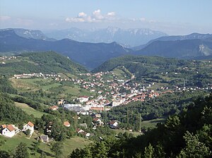
Prozor-Rama
Town and municipality in Federation of Bosnia and Herzegovina, Bosnia and Herzegovina
Distance: Approx. 253 meters
Latitude and longitude: 43.82,17.61
Prozor-Rama (Serbian Cyrillic: Прозор-Рама) is a municipality located in Herzegovina-Neretva Canton of the Federation of Bosnia and Herzegovina, an entity of Bosnia and Herzegovina. Its seat is Prozor. Also, Ramsko lake is located in the municipality.

Operation Neretva '93
Distance: Approx. 962 meters
Latitude and longitude: 43.81666667,17.6
Operation Neretva '93 was an Army of the Republic of Bosnia and Herzegovina (ARBiH) operation against the Croatian Defence Council (HVO) in September 1993 on a 200 km long front from Gornji Vakuf to south of Mostar, one of its largest of the year, during the Croat–Bosniak War. The ARBiH made limited gains in the area of northern Herzegovina and around Mostar, but did not achieve a breakthrough to the southern Neretva, where the HVO retained control. The operation was halted in October.

Radio Rama
Bosnian radio station
Distance: Approx. 253 meters
Latitude and longitude: 43.82,17.61
Radio Rama or Radio postaja Rama is a Bosnian local public radio station, broadcasting from Prozor-Rama, Bosnia and Herzegovina. It was launched on 6 June 1993 by local municipal council as public company JP "Radio Rama" d.o.o.. This radio station broadcasts a variety of programs such as music, talk shows and local news.
Blace, Prozor-Rama
Village in Federation of Bosnia and Herzegovina, Bosnia and Herzegovina
Distance: Approx. 3207 meters
Latitude and longitude: 43.8276897,17.6484048
Blace is a village in the municipality of Prozor-Rama, Bosnia and Herzegovina.
Borovnica, Prozor-Rama
Village in Federation of Bosnia and Herzegovina, Bosnia and Herzegovina
Distance: Approx. 1452 meters
Latitude and longitude: 43.810901,17.6001622
Borovnica is a village in the municipality of Prozor-Rama, Bosnia and Herzegovina.
Dobroša
Village in Federation of Bosnia and Herzegovina, Bosnia and Herzegovina
Distance: Approx. 2275 meters
Latitude and longitude: 43.8283007,17.6362417
Dobroša is a village in the municipality of Prozor-Rama, Bosnia and Herzegovina.
Donja Vast
Village in Federation of Bosnia and Herzegovina, Bosnia and Herzegovina
Distance: Approx. 3207 meters
Latitude and longitude: 43.8276897,17.6484048
Donja Vast is a village in the municipality of Prozor-Rama, Bosnia and Herzegovina.
Gmići
Village in Federation of Bosnia and Herzegovina, Bosnia and Herzegovina
Distance: Approx. 2391 meters
Latitude and longitude: 43.8348363,17.5851217
Gmići is a village in the municipality of Prozor-Rama, Bosnia and Herzegovina.
Gračanica, Prozor
Village in Federation of Bosnia and Herzegovina, Bosnia and Herzegovina
Distance: Approx. 3207 meters
Latitude and longitude: 43.8276897,17.6484048
Gračanica is a village in the municipality of Prozor-Rama, Bosnia and Herzegovina.
Grevići
Village in Federation of Bosnia and Herzegovina, Bosnia and Herzegovina
Distance: Approx. 2275 meters
Latitude and longitude: 43.8283007,17.6362417
Grevići is a village in the municipality of Prozor-Rama, Bosnia and Herzegovina.
Here, Prozor
Village in Federation of Bosnia and Herzegovina, Bosnia and Herzegovina
Distance: Approx. 2275 meters
Latitude and longitude: 43.8283007,17.6362417
Here is a village in the municipality of Prozor-Rama, Bosnia and Herzegovina.
Ometala
Village in Federation of Bosnia and Herzegovina, Bosnia and Herzegovina
Distance: Approx. 3119 meters
Latitude and longitude: 43.8262874,17.5707825
Ometala is a village in the municipality of Prozor-Rama, Bosnia and Herzegovina.
Weather in this IP's area
clear sky
-3 Celsius
-6 Celsius
-3 Celsius
-3 Celsius
1032 hPa
68 %
1032 hPa
900 hPa
10000 meters
1.98 m/s
2.29 m/s
39 degree