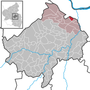
Country:
Region:
City:
Latitude and Longitude:
Time Zone:
Postal Code:
IP information under different IP Channel
ip-api
Country
Region
City
ASN
Time Zone
ISP
Blacklist
Proxy
Latitude
Longitude
Postal
Route
Luminati
Country
ASN
Time Zone
Europe/Berlin
ISP
VSE NET GmbH
Latitude
Longitude
Postal
IPinfo
Country
Region
City
ASN
Time Zone
ISP
Blacklist
Proxy
Latitude
Longitude
Postal
Route
db-ip
Country
Region
City
ASN
Time Zone
ISP
Blacklist
Proxy
Latitude
Longitude
Postal
Route
ipdata
Country
Region
City
ASN
Time Zone
ISP
Blacklist
Proxy
Latitude
Longitude
Postal
Route
Popular places and events near this IP address

Waldalgesheim
Municipality in Rhineland-Palatinate, Germany
Distance: Approx. 252 meters
Latitude and longitude: 49.95111111,7.83638889
Waldalgesheim is an Ortsgemeinde – a municipality belonging to a Verbandsgemeinde, a kind of collective municipality – in the Mainz-Bingen district in Rhineland-Palatinate, Germany. It is best known as the site of the Iron Age Waldalgesheim chariot burial. The winegrowing centre belongs to the Verbandsgemeinde of Rhein-Nahe, whose seat is in Bingen am Rhein, although that town is not within its bounds.

Stromberg (Hunsrück)
Town in Rhineland-Palatinate, Germany
Distance: Approx. 3875 meters
Latitude and longitude: 49.94694444,7.77944444
Stromberg is a town in the district of Bad Kreuznach, in Rhineland-Palatinate, Germany. It is situated on the eastern edge of the Hunsrück, approximately 10 km west of Bingen. Stromberg was the seat of the former Verbandsgemeinde ("collective municipality") Stromberg.

Dorsheim
Municipality in Rhineland-Palatinate, Germany
Distance: Approx. 3973 meters
Latitude and longitude: 49.92527778,7.87333333
Dorsheim is an Ortsgemeinde – a municipality belonging to a Verbandsgemeinde, a kind of collective municipality – in the Bad Kreuznach district in Rhineland-Palatinate, Germany. It belongs to the Verbandsgemeinde Langenlonsheim-Stromberg, whose seat is in Langenlonsheim. Dorsheim is a winegrowing centre.

Roth, Bad Kreuznach
German municipality in Bad Kreuznach district
Distance: Approx. 2351 meters
Latitude and longitude: 49.94444444,7.80166667
Roth is an Ortsgemeinde – a municipality belonging to a Verbandsgemeinde, a kind of collective municipality – in the Bad Kreuznach district in Rhineland-Palatinate, Germany. It belongs to the Verbandsgemeinde Langenlonsheim-Stromberg, whose seat is in Langenlonsheim.

Rümmelsheim
Municipality in Rhineland-Palatinate, Germany
Distance: Approx. 2683 meters
Latitude and longitude: 49.93444444,7.86194444
Rümmelsheim is an Ortsgemeinde – a municipality belonging to a Verbandsgemeinde, a kind of collective municipality – in the Bad Kreuznach district in Rhineland-Palatinate, Germany. It belongs to the Verbandsgemeinde Langenlonsheim-Stromberg, whose seat is in Langenlonsheim. Rümmelsheim is a winegrowing village.

Schweppenhausen
Municipality in Rhineland-Palatinate, Germany
Distance: Approx. 3284 meters
Latitude and longitude: 49.92833333,7.80222222
Schweppenhausen is a municipality in the district of Bad Kreuznach in Rhineland-Palatinate, in western Germany.

Waldlaubersheim
Municipality in Rhineland-Palatinate, Germany
Distance: Approx. 2165 meters
Latitude and longitude: 49.93055556,7.83277778
Waldlaubersheim is a municipality in the district of Bad Kreuznach in Rhineland-Palatinate, in western Germany. As of the 2020 census it had a total population of 801. Waldlaubersheim's postal code is 55444.

Warmsroth
Municipality in Rhineland-Palatinate, Germany
Distance: Approx. 3303 meters
Latitude and longitude: 49.95616389,7.78821944
Warmsroth is a municipality in the district of Bad Kreuznach in Rhineland-Palatinate, in western Germany.
Stromberg (Verbandsgemeinde)
Distance: Approx. 4120 meters
Latitude and longitude: 49.947,7.776
Stromberg is a former Verbandsgemeinde ("collective municipality") in the district of Bad Kreuznach, Rhineland-Palatinate, Germany. The seat of the Verbandsgemeinde was in Stromberg. On 1 January 2020 it was merged into the new Verbandsgemeinde Langenlonsheim-Stromberg.

Weiler bei Bingen
Municipality in Rhineland-Palatinate, Germany
Distance: Approx. 2559 meters
Latitude and longitude: 49.95777778,7.86694444
Weiler bei Bingen is an Ortsgemeinde – a municipality belonging to a Verbandsgemeinde, a kind of collective municipality – in the Mainz-Bingen district in Rhineland-Palatinate, Germany. The winegrowing centre belongs to the Verbandsgemeinde of Rhein-Nahe, whose seat is in Bingen am Rhein, although that town is not within its bounds.
Genheim
Ortsteil of Waldalgesheim in Rhineland-Palatinate, Germany
Distance: Approx. 1689 meters
Latitude and longitude: 49.939444,7.816389
Genheim is a village and an Ortsteil (subdivision) of the municipality Waldalgesheim in the district Mainz-Bingen in Rhineland-Palatinate, Germany. The village is managed by the collective municipality of Rhein-Nahe, which has its administrative office in Bingen am Rhein.

Waldalgesheim chariot burial
4th-century BC Celtic princely chariot burial site
Distance: Approx. 633 meters
Latitude and longitude: 49.955156,7.829601
The Waldalgesheim chariot burial (German: Waldalgesheimer Fürstengrab) was a 4th-century BC Celtic princely chariot burial site in Waldalgesheim, Germany, discovered in 1869. It has given its name to the "Waldalgesheim Style" of artifacts of the La Tène culture, a more fluid and confident style of decoration than early Celtic art, with Greek and Etruscan influences. The objects from the burial site were dug up by the farmer who found them on his land.
Weather in this IP's area
clear sky
6 Celsius
6 Celsius
5 Celsius
7 Celsius
1027 hPa
99 %
1027 hPa
991 hPa
10000 meters
0.24 m/s
0.34 m/s
271 degree
5 %
07:33:37
16:51:43
