Country:
Region:
City:
Latitude and Longitude:
Time Zone:
Postal Code:
IP information under different IP Channel
ip-api
Country
Region
City
ASN
Time Zone
ISP
Blacklist
Proxy
Latitude
Longitude
Postal
Route
Luminati
Country
ASN
Time Zone
Europe/Berlin
ISP
VSE NET GmbH
Latitude
Longitude
Postal
IPinfo
Country
Region
City
ASN
Time Zone
ISP
Blacklist
Proxy
Latitude
Longitude
Postal
Route
db-ip
Country
Region
City
ASN
Time Zone
ISP
Blacklist
Proxy
Latitude
Longitude
Postal
Route
ipdata
Country
Region
City
ASN
Time Zone
ISP
Blacklist
Proxy
Latitude
Longitude
Postal
Route
Popular places and events near this IP address

Langenlonsheim
Municipality in Rhineland-Palatinate, Germany
Distance: Approx. 2597 meters
Latitude and longitude: 49.89472222,7.89805556
Langenlonsheim is an Ortsgemeinde – a municipality belonging to a Verbandsgemeinde, a kind of collective municipality – in the Bad Kreuznach district in Rhineland-Palatinate, Germany. It belongs to the Verbandsgemeinde Langenlonsheim-Stromberg, and is also its seat. Langenlonsheim is a state-recognized tourism community and a winegrowing village.

Biebelsheim
Municipality in Rhineland-Palatinate, Germany
Distance: Approx. 3037 meters
Latitude and longitude: 49.87305556,7.94
Biebelsheim is an Ortsgemeinde – a municipality belonging to a Verbandsgemeinde, a kind of collective municipality – in the Bad Kreuznach district in Rhineland-Palatinate, Germany. It belongs to the Verbandsgemeinde of Bad Kreuznach, whose seat is in the like-named town, although this lies outside the Verbandsgemeinde.
Bretzenheim
Municipality in Rhineland-Palatinate, Germany
Distance: Approx. 3488 meters
Latitude and longitude: 49.87805556,7.89861111
Bretzenheim is an Ortsgemeinde – a municipality belonging to a Verbandsgemeinde, a kind of collective municipality – in the Bad Kreuznach district in Rhineland-Palatinate, Germany. It belongs to the Verbandsgemeinde Langenlonsheim-Stromberg, whose seat is in Langenlonsheim. Bretzenheim is a state-recognized tourism community and a winegrowing centre.

Laubenheim
Municipality in Rhineland-Palatinate, Germany
Distance: Approx. 3375 meters
Latitude and longitude: 49.92027778,7.89833333
Laubenheim is an Ortsgemeinde – a municipality belonging to a Verbandsgemeinde, a kind of collective municipality – in the Bad Kreuznach district in Rhineland-Palatinate, Germany. It belongs to the Verbandsgemeinde Langenlonsheim-Stromberg, whose seat is in Langenlonsheim. Laubenheim is a winegrowing village.
Langenlonsheim (Verbandsgemeinde)
Distance: Approx. 2702 meters
Latitude and longitude: 49.89,7.899
Langenlonsheim is a former Verbandsgemeinde ("collective municipality") in the district of Bad Kreuznach, Rhineland-Palatinate, Germany. The seat of the Verbandsgemeinde was in Langenlonsheim. On 1 January 2020 it was merged into the new Verbandsgemeinde Langenlonsheim-Stromberg.

Aspisheim
Municipality in Rhineland-Palatinate, Germany
Distance: Approx. 3604 meters
Latitude and longitude: 49.9075,7.98222222
Aspisheim is an Ortsgemeinde – a municipality belonging to a Verbandsgemeinde, a kind of collective municipality – in the Mainz-Bingen district in Rhineland-Palatinate, Germany.

Gensingen
Municipality in Rhineland-Palatinate, Germany
Distance: Approx. 436 meters
Latitude and longitude: 49.89805556,7.92805556
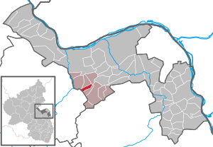
Gensingen is an Ortsgemeinde – a municipality belonging to a Verbandsgemeinde, a kind of collective municipality – in the Mainz-Bingen district in Rhineland-Palatinate, Germany.

Grolsheim
Municipality in Rhineland-Palatinate, Germany
Distance: Approx. 1676 meters
Latitude and longitude: 49.91055556,7.91666667
Grolsheim is an Ortsgemeinde – a municipality belonging to a Verbandsgemeinde, a kind of collective municipality – in the Mainz-Bingen district in Rhineland-Palatinate, Germany.

Horrweiler
Municipality in Rhineland-Palatinate, Germany
Distance: Approx. 2140 meters
Latitude and longitude: 49.89833333,7.96305556
Horrweiler is an Ortsgemeinde – a municipality belonging to a Verbandsgemeinde, a kind of collective municipality – in the Mainz-Bingen district in Rhineland-Palatinate, Germany.

Welgesheim
Municipality in Rhineland-Palatinate, Germany
Distance: Approx. 2851 meters
Latitude and longitude: 49.88222222,7.96194444
Welgesheim is an Ortsgemeinde – a municipality belonging to a Verbandsgemeinde, a kind of collective municipality – in the Mainz-Bingen district in Rhineland-Palatinate, Germany.

Langenlonsheim station
Junction station in Langenlonsheim, Rhineland-Palatinate, Germany
Distance: Approx. 2402 meters
Latitude and longitude: 49.901317,7.899887
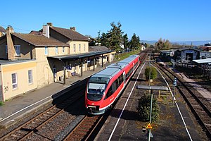
Langenlonsheim station is a junction station in the town of Langenlonsheim in the German state of Rhineland-Palatinate. It is located at line-kilometre 8.0 of the Nahe Valley Railway (Nahetalbahn) and has three platforms. The Trans-Hunsrück Railway (Hunsrückquerbahn) branches in the station towards Simmern; it is still used as far as Stromberg for freight traffic.
Langenlonsheim-Stromberg
Verbandsgemeinde in Rhineland-Palatinate, Germany
Distance: Approx. 2390 meters
Latitude and longitude: 49.9,7.9
Langenlonsheim-Stromberg is a Verbandsgemeinde ("collective municipality") in the district of Bad Kreuznach, Rhineland-Palatinate, Germany. The seat of the Verbandsgemeinde is in Langenlonsheim. It was formed on 1 January 2020 by the merger of the former Verbandsgemeinden Langenlonsheim and Stromberg.
Weather in this IP's area
clear sky
7 Celsius
7 Celsius
6 Celsius
8 Celsius
1027 hPa
92 %
1027 hPa
1014 hPa
10000 meters
0.01 m/s
0.26 m/s
5 degree
4 %
07:33:04
16:51:29
