91.147.207.68 - IP Lookup: Free IP Address Lookup, Postal Code Lookup, IP Location Lookup, IP ASN, Public IP
Country:
Region:
City:
Location:
Time Zone:
Postal Code:
ISP:
ASN:
language:
User-Agent:
Proxy IP:
Blacklist:
IP information under different IP Channel
ip-api
Country
Region
City
ASN
Time Zone
ISP
Blacklist
Proxy
Latitude
Longitude
Postal
Route
db-ip
Country
Region
City
ASN
Time Zone
ISP
Blacklist
Proxy
Latitude
Longitude
Postal
Route
IPinfo
Country
Region
City
ASN
Time Zone
ISP
Blacklist
Proxy
Latitude
Longitude
Postal
Route
IP2Location
91.147.207.68Country
Region
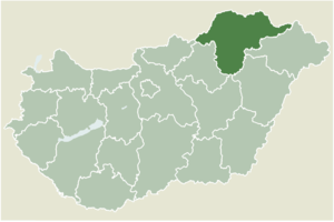
borsod-abauj-zemplen
City
izsofalva
Time Zone
Europe/Budapest
ISP
Language
User-Agent
Latitude
Longitude
Postal
ipdata
Country
Region
City
ASN
Time Zone
ISP
Blacklist
Proxy
Latitude
Longitude
Postal
Route
Popular places and events near this IP address
Kazincbarcika
Town in Borsod-Abaúj-Zemplén, Hungary
Distance: Approx. 5444 meters
Latitude and longitude: 48.25315,20.64563
Kazincbarcika is an industrial town in Borsod–Abaúj–Zemplén county, Northern Hungary. It is the district seat of Kazincbarcika District. It lies in the valley of the river Duna, 24 kilometres (15 miles) from the county capital, Nyíregyháza.

Edelény
Place in Northern Hungary, Hungary
Distance: Approx. 5751 meters
Latitude and longitude: 48.2967,20.7442
Edelény is a town in Borsod-Abaúj-Zemplén county, Northern Hungary. It lies in the valley of Bódva River, 25 km (16 mi) north of the county seat, Miskolc. The historic L'Huillier-Coburg Palace is located there.
Berente
Village in Northern Hungary, Hungary
Distance: Approx. 6216 meters
Latitude and longitude: 48.24421,20.66331
Berente is a village in Borsod-Abaúj-Zemplén county, Hungary.
Rudolftelep
Village in Northern Hungary, Hungary
Distance: Approx. 1030 meters
Latitude and longitude: 48.30901,20.66988
Rudolftelep is a village in Borsod-Abaúj-Zemplén county, Hungary.

Kurityán
Place in Borsod-Abaúj-Zemplén, Hungary
Distance: Approx. 3493 meters
Latitude and longitude: 48.3131,20.62384
Kurityán is a village in Borsod-Abaúj-Zemplén county, Hungary.
Szuhakálló
Village in Northern Hungary, Hungary
Distance: Approx. 2035 meters
Latitude and longitude: 48.28297,20.6567
Szuhakálló is a village in Borsod-Abaúj-Zemplén county, Hungary.
Felsőnyárád
Village in Northern Hungary, Hungary
Distance: Approx. 5966 meters
Latitude and longitude: 48.328619,20.598569
Felsőnyárád is a village in Borsod-Abaúj-Zemplén County in northeastern Hungary. As of 2008, the village had a population of 1058.
Izsófalva
Large village in Borsod-Abaúj-Zemplén, Hungary
Distance: Approx. 2 meters
Latitude and longitude: 48.3,20.66666667
Izsófalva (formerly Disznóshorvát) is a village in Borsod-Abaúj-Zemplén County in northeastern Hungary. The village has a population of 1,871.
Múcsony
Large village in Borsod-Abaúj-Zemplén, Hungary
Distance: Approx. 3910 meters
Latitude and longitude: 48.26666667,20.68333333
Múcsony (Slovak: Mučoň; Rusyn: Мучонь) is a village in Borsod-Abaúj-Zemplén County in northeastern Hungary.
Ormosbánya
Village in Northern Hungary, Hungary
Distance: Approx. 4267 meters
Latitude and longitude: 48.33635,20.64843
Ormosbánya is a village in Borsod-Abaúj-Zemplén County in northeastern Hungary.
Kazincbarcika Subregion
Distance: Approx. 6445 meters
Latitude and longitude: 48.31666667,20.58333333
Kazincbarcika Subregion Borsod-Abaúj-Zemplén third largest of the subregions of Hungary, with an area of 499.3 square kilometres and population of 60,332 in 2009.

L'Huillier-Coburg Palace
Distance: Approx. 5416 meters
Latitude and longitude: 48.2936,20.7392
L'Huillier-Coburg Palace in Edelény is the seventh largest palace in Hungary. This prominent example of early Baroque architecture was built between 1716 and 1730 by Jean-Francois L'Huillier, who originated from Alsace-Lorraine, France. In 1727, L'Huillier became the full owner of the palace with the king's consent.
Weather in this IP's area
overcast clouds
3 Celsius
2 Celsius
3 Celsius
4 Celsius
1018 hPa
87 %
1018 hPa
991 hPa
10000 meters
1.35 m/s
1.91 m/s
98 degree
100 %
