Country:
Region:
City:
Latitude and Longitude:
Time Zone:
Postal Code:
IP information under different IP Channel
ip-api
Country
Region
City
ASN
Time Zone
ISP
Blacklist
Proxy
Latitude
Longitude
Postal
Route
Luminati
Country
ASN
Time Zone
Asia/Riyadh
ISP
Digital Solutions Provider
Latitude
Longitude
Postal
IPinfo
Country
Region
City
ASN
Time Zone
ISP
Blacklist
Proxy
Latitude
Longitude
Postal
Route
db-ip
Country
Region
City
ASN
Time Zone
ISP
Blacklist
Proxy
Latitude
Longitude
Postal
Route
ipdata
Country
Region
City
ASN
Time Zone
ISP
Blacklist
Proxy
Latitude
Longitude
Postal
Route
Popular places and events near this IP address

Al-Balad, Jeddah
Historical place in Jeddah, Saudi Arabia
Distance: Approx. 1925 meters
Latitude and longitude: 21.48333333,39.18333333
Al-Balad (Arabic: البلد), also known as Jeddah Historic District (Arabic: جدة التاريخية), is the historical area of Jeddah, the second largest city of Saudi Arabia. Al-Balad can literally be translated to "The Town". Al-Balad is the historic center of the City of Jeddah.

King Saud Mosque
Mosque in Jeddah, Saudi Arabia
Distance: Approx. 2353 meters
Latitude and longitude: 21.52166667,39.1825
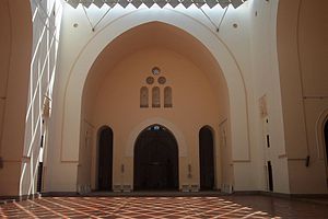
His Majesty King Saud Mosque (Arabic: مسجد الملك سعود) is the largest mosque in the city of Jeddah and is located in Jeddah's Al-Sharafeyyah District. The mosque was designed by Abdel-Wahed El-Wakil and construction was completed in 1987. It is mainly built of bricks and covers an area of 9,700 square metres (104,000 sq ft) with the prayer hall alone covering 2,464 square metres (26,520 sq ft).

Jeddah Islamic Port
Largest port of Saudi Arabia
Distance: Approx. 2185 meters
Latitude and longitude: 21.483843,39.17340683
Jeddah Islamic Port is a Saudi Arabian port, located in Jeddah on the Red Sea, at the middle of an international shipping route between the east and west via the Suez Canal. It is the second-largest and second-busiest port in the Arab world (after the Port of Jebel Ali in Dubai, UAE). The city of Jeddah is the second-largest city in Saudi Arabia (after the capital Riyadh), and is Saudi Arabia's commercial capital.

Tomb of Eve
Archeological site in Jeddah, Saudi Arabia
Distance: Approx. 1145 meters
Latitude and longitude: 21.4919,39.1903
The Tomb of Eve, also known as Eve's Grave and Eve's Tomb, is an archeological site located in Jeddah, Saudi Arabia. It is considered by some Muslims to be the burial place of Eve. Prince Faisal, Viceroy of Hejaz, destroyed it in 1928.
Jeddah TV Tower
Tower in Jeddah, Saudi Arabia
Distance: Approx. 3455 meters
Latitude and longitude: 21.472973,39.19961
The Jeddah TV Tower (برج تلفزيون جدة) in Jeddah, Saudi Arabia is a 250-metre-high (820 ft) television tower with an observation deck. The tower was completed in 2006.

Nasseef House
Historical structure in Saudi Arabia
Distance: Approx. 1893 meters
Latitude and longitude: 21.48388889,39.18777778
Nasseef House or Nassif House (Arabic: بيت نصيف Bayt Nasseef) is a historical structure in Al-Balad, Jeddah, Saudi Arabia. As of 2009, it is a museum and cultural center which has special exhibits and lectures given by historians.
Qishla of Jeddah
Castle in Jeddah, Saudi Arabia, built in 1525 for the Ottoman army
Distance: Approx. 1171 meters
Latitude and longitude: 21.49083333,39.18861111
The Qishla of Jeddah (Turkish: Cidde Redif Kışlası) is a historical edifice in Jeddah, Saudi Arabia, built in 1525 to be a military castle of the Ottoman army. Today, the ruins of the castle lay beneath the Jeddah branch of the ministry of defense. Qishla (modern Turkish: Kışla) is a Turkish word meaning "barracks".

2009 Jeddah floods
2009 natural disaster in Jeddah, Saudi Arabia
Distance: Approx. 129 meters
Latitude and longitude: 21.5,39.18333333
The 2009 Saudi Arabian floods affected Jeddah, on the Red Sea (western) coast of Saudi Arabia, and other areas of Makkah Province. They have been described by civil defence officials as the worst in 27 years. As of 3 January 2010, some 122 people had been reported to have been killed, and more than 350 were missing.
International Medical Center
Hospital in Jeddah, Saudi Arabia
Distance: Approx. 1778 meters
Latitude and longitude: 21.51361111,39.17444444
International Medical Center or IMC is a large hospital in Jeddah, Saudi Arabia, and was built in 2005. The CEO of the center is Dr. Walid Fitaihi.
Jeddah Flagpole
Flagpole in western Saudi Arabia; second tallest in the world
Distance: Approx. 1720 meters
Latitude and longitude: 21.507843,39.169732
The Jeddah Flagpole is a freestanding flagpole in Jeddah, Saudi Arabia. Standing 171 metres (561 ft) high, it was the tallest flagpole in the world from 2014 until 2021, when the Cairo Flagpole in Cairo, Egypt was erected at a height of 201.952 m (662.57 ft). The cylindrical flagpole was built of 500 tons of steel in September 2014 by the Abdul Latif Jameel Community Initiative and Al-Babtain Power & Telecom.

Non-Muslim Cemetery
Cemetery in Jeddah, Saudi Arabia
Distance: Approx. 2579 meters
Latitude and longitude: 21.47747,39.18299
The Non-Muslim Cemetery ("NMC" or Christian Cemetery) is a cemetery in Jeddah in the Hejaz region of Saudi Arabia. It is located on the King Fahd Branch Road, in Jeddah's Al-Balad district. The cemetery contains more than 400 graves.
National Center for Meteorology (Saudi Arabia)
Weather research and forecasting organization
Distance: Approx. 3611 meters
Latitude and longitude: 21.523335,39.209268
The National Center for Meteorology (NCM; Arabic: المركز الوطني للأرصاد) is the national meteorological research and forecasting organization of Saudi Arabia, working under the Ministry of Environment, Water, and Agriculture of the Government of Saudi Arabia. The center was established in March 2019. The center is tasked with weather forecasting, issuing early warnings, and collaborating with other international meteorology institutions to employ the latest technologies.
Weather in this IP's area
clear sky
31 Celsius
36 Celsius
31 Celsius
31 Celsius
1011 hPa
63 %
1011 hPa
1010 hPa
10000 meters
5.99 m/s
5.41 m/s
307 degree
06:29:14
17:44:34
