Country:
Region:
City:
Latitude and Longitude:
Time Zone:
Postal Code:
IP information under different IP Channel
ip-api
Country
Region
City
ASN
Time Zone
ISP
Blacklist
Proxy
Latitude
Longitude
Postal
Route
Luminati
Country
ASN
Time Zone
Europe/Amsterdam
ISP
Signet B.V.
Latitude
Longitude
Postal
IPinfo
Country
Region
City
ASN
Time Zone
ISP
Blacklist
Proxy
Latitude
Longitude
Postal
Route
db-ip
Country
Region
City
ASN
Time Zone
ISP
Blacklist
Proxy
Latitude
Longitude
Postal
Route
ipdata
Country
Region
City
ASN
Time Zone
ISP
Blacklist
Proxy
Latitude
Longitude
Postal
Route
Popular places and events near this IP address

Drechtsteden
Distance: Approx. 2835 meters
Latitude and longitude: 51.81666667,4.68333333
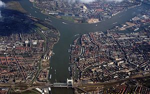
The Drechtsteden (Dutch pronunciation: [ˈdrɛxtsteːdə(n)]; Dutch for "Drecht cities") are a number of towns and cities bordering each other in the delta area of the rivers Oude Maas, Noord, and Beneden-Merwede in the province of South Holland, Netherlands. These cooperate in the Gemeenschappelijke Regeling Drechtsteden ("joint arrangement Drechtsteden"), which performs common tasks for the municipalities in the field of economy, development, culture, and social assistance. Collectively, a little more than 250,000 people call one of the towns and cities of Drechtsteden home.

Alblasserdam
Municipality in South Holland, Netherlands
Distance: Approx. 3249 meters
Latitude and longitude: 51.87016667,4.66666667
Alblasserdam (Dutch: [ɑlˌblɑsərˈdɑm] ) is a town and municipality in the western Netherlands, in the province of South Holland. It covers an area of 10.06 km2 (3.88 sq mi), of which 1.28 km2 (0.49 sq mi) is water, and has a population of 20,136 as of 2021. Alblasserdam is officially a part of the Drechtsteden region.
Papendrecht
Municipality in South Holland, Netherlands
Distance: Approx. 1009 meters
Latitude and longitude: 51.83333333,4.68333333
Papendrecht (Dutch pronunciation: [ˈpaːpə(n)drɛxt] ) is a town and municipality in the western Netherlands, in the province of South Holland, at the crossing of the River Beneden Merwede and the Noord River. The municipality had a population of 32,171 in 2021 and covers an area of 10.79 km2 (4.17 sq mi) of which 1.38 km2 (0.53 sq mi) is water. Although Papendrecht is first mentioned in documents dating back to 1105, it remained a small settlement until the 1950s.

Beneden Merwede
Distance: Approx. 2796 meters
Latitude and longitude: 51.817,4.683
The Beneden Merwede (Dutch pronunciation: [bəˌneːdə ˈmɛrʋeːdə]; "Lower Merwede") is a stretch of river in the Netherlands, mainly fed by the river Rhine. It starts as the continuation of the Boven Merwede after the branching-off of the Nieuwe Merwede ship canal. It flows from Hardinxveld-Giessendam to Dordrecht, where it splits into the Noord and Oude Maas rivers.

Oud-Alblas
Village in South Holland, Netherlands
Distance: Approx. 3101 meters
Latitude and longitude: 51.86666667,4.7
Oud-Alblas is a village in the Dutch province of South Holland. It is a part of the municipality of Molenlanden, and lies about 6 km north of Dordrecht. In 2001, the village of Oud-Alblas had 1291 inhabitants.

Merwede
River in the Netherlands
Distance: Approx. 2946 meters
Latitude and longitude: 51.81666667,4.66666667
The Merwede (Dutch pronunciation: [ˈmɛrʋeːdə]; etymology uncertain, possibly derived from the Old Dutch merwe or merowe, a word meaning "wide water") is the name of several connected stretches of river in the Netherlands, between the cities of Woudrichem, Dordrecht and Papendrecht. The river is part of the Rhine–Meuse–Scheldt delta and is mostly fed by the river Rhine. At first, a disconnected branch of the Meuse joins the Waal at Woudrichem to form the Boven Merwede (Upper Merwede).

Johan's Ark
Reconstruction of Noah's Ark, Netherlands
Distance: Approx. 2580 meters
Latitude and longitude: 51.81912222,4.68506667
Johan's Ark is a Noah's Ark-themed barge in Dordrecht, Netherlands, which was built by the Dutch building contractor, carpenter and creationist Johan Huibers. It is a full-scale interpretation of the biblical Ark, featuring animal models, including cows, penguins, a crocodile, and a giraffe. It opened to the public in 2012.

Noord (river)
River in South Holland, Netherlands
Distance: Approx. 1780 meters
Latitude and longitude: 51.85111111,4.65777778
The Noord ("North") is a short tidal river in the western Netherlands, in the province of South Holland. The Noord starts at the city of Dordrecht where the Beneden Merwede river forks into the Oude Maas and the Noord. It joins the Lek at the city of Ridderkerk and Kinderdijk, and the combined stream is thereafter known as the Nieuwe Maas.

Noordtunnel
Distance: Approx. 2457 meters
Latitude and longitude: 51.8575,4.65361111
The Noord Tunnel is a tunnel under the Noord on the motorway A15 around Rotterdam.
De Brave Hendrik
Restaurant in Hendrik-Ido-Ambacht, Netherlands
Distance: Approx. 2848 meters
Latitude and longitude: 51.85242778,4.64123889
De Brave Hendrik was a fine dining restaurant in Hendrik-Ido-Ambacht, Netherlands. It was awarded one Michelin star in 1990 and retained that rating until 1996.

Groothoofdspoort
City Gate in Dordrecht
Distance: Approx. 2582 meters
Latitude and longitude: 51.81944444,4.67027778
The Groothoofdspoort is a former city gate in Dordrecht that is located at the point where three rivers meet; the Merwede, the Oude Maas, and the Noord.

Binnenvaartmuseum
Maritime museum in Dordrecht, Netherlands
Distance: Approx. 2805 meters
Latitude and longitude: 51.8172,4.6863
Binnenvaartmuseum ('Inland Shipping Museum') is a floating museum in Dordrecht, South Holland, Netherlands, on the Wantij waterway near the former shipyard De Biesbosch.
Weather in this IP's area
overcast clouds
9 Celsius
9 Celsius
8 Celsius
10 Celsius
1024 hPa
91 %
1024 hPa
1024 hPa
10000 meters
0.89 m/s
2.24 m/s
220 degree
100 %
08:01:11
16:50:55
