Country:
 Greece
Region:
City:
Latitude and Longitude:
Time Zone:
Postal Code:
IP information under different IP Channel
ip-api
Country
Region
City
ASN
Time Zone
ISP
Blacklist
Proxy
Latitude
Longitude
Postal
Route
IPinfo
Country
Region
City
ASN
Time Zone
ISP
Blacklist
Proxy
Latitude
Longitude
Postal
Route
MaxMind
Country
Region
City
ASN
Time Zone
ISP
Blacklist
Proxy
Latitude
Longitude
Postal
Route
Luminati
Country
GRRegion
i
City
athens
ASN
Time Zone
Europe/Athens
ISP
Nova Telecommunications & Media Single Member S.A
Latitude
Longitude
Postal
db-ip
Country
Region
City
ASN
Time Zone
ISP
Blacklist
Proxy
Latitude
Longitude
Postal
Route
ipdata
Country
Region
City
ASN
Time Zone
ISP
Blacklist
Proxy
Latitude
Longitude
Postal
Route
Popular places and events near this IP address

Athens International Airport
International airport serving Athens, Greece
Distance: Approx. 5548 meters
Latitude and longitude: 37.93638889,23.94722222
Athens International Airport Eleftherios Venizelos (IATA: ATH, ICAO: LGAV), commonly initialised as AIA, is the largest international airport in Greece, serving the city of Athens and region of Attica. It began operation on 28 March 2001 (in time for the 2004 Summer Olympics) and is the main base of Aegean Airlines, as well as other smaller Greek airlines. It replaced the old Ellinikon International Airport.

Rafina
Municipal unit in Greece
Distance: Approx. 5503 meters
Latitude and longitude: 38.01666667,24
Rafina (Greek: Ραφήνα) is a suburban port town located on the eastern coast of Attica in Greece. It has a population of 14,620 inhabitants (2021 census). Since the 2011 local government reform it is part of the municipality Rafina-Pikermi, of which it is the seat and a municipal unit.

Artemida, Attica
Municipal unit in Greece
Distance: Approx. 290 meters
Latitude and longitude: 37.96666667,24
Artemida (Greek: Αρτέμιδα, until 1977 Loutsa, Greek: Λούτσα) is an Eastern suburb of Athens. Since the 2011 local government reform it is part of the municipality Spata-Artemida, of which it is a municipal unit. The municipal unit has an area of 18.653 km2.
Brauron
City of ancient Attica, Greece
Distance: Approx. 4594 meters
Latitude and longitude: 37.92611111,23.99361111
Brauron (; Ancient Greek: Βραυρών) was one of the twelve cities of ancient Attica, but never mentioned as a deme, though it continued to exist down to the latest times. It was situated on or near the eastern coast of Attica, between Steiria and Halae Araphenides, near the river Erasinus. Brauron is celebrated on account of the worship of Artemis Brauronia, in whose honor a festival was celebrated in this place.

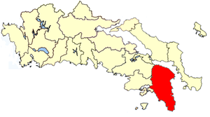
East Attica
Regional unit in Greece
Distance: Approx. 5487 meters
Latitude and longitude: 38,23.95
East Attica (Greek: Ανατολική Αττική) is one of the regional units of Greece. It is part of the region of Attica. The regional unit covers the eastern part of the urban agglomeration of Athens, and also the rural area to its east.

Athens International Airport Archaeological Collection
Distance: Approx. 5562 meters
Latitude and longitude: 37.9364,23.947
The Athens International Airport Archaeological Collection is a museum on level 2 outside security in the main terminal building of Athens International Airport in Spata, Attica, Greece. The collection was established in 2003 and houses 177 ancient artefacts which were uncovered during construction work at the site, once a flourishing agricultural area in ancient times.

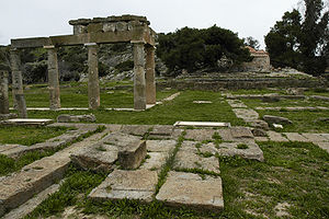
Archaeological Museum of Brauron
Museum in Greece
Distance: Approx. 4776 meters
Latitude and longitude: 37.9244,23.9969
The Brauron Archaeological Museum is a museum in Markopoulo Mesogeias, Greece. Much of the collection is derived from excavations in the Sanctuary of Artemis at Brauron. Of note is a statue representing a small girl, a so-called "bear" (arktoi) (Medvedicka).
Attica Province
Distance: Approx. 5621 meters
Latitude and longitude: 38.01666667,23.98333333
The province of Attica (Greek: Επαρχία Αττικής) was one of the provinces of Attica, Greece. It consisted of parts of the East Attica and West Attica prefectures. Its territory corresponded with that of the current municipalities Acharnes, Dionysos, Kropia, Lavreotiki, Marathon, Markopoulo Mesogaias, Oropos, Paiania, Pallini (except the municipal unit Gerakas), Rafina-Pikermi, Saronikos, Spata-Artemida and Fyli.

Rafina-Pikermi
Municipality in Greece
Distance: Approx. 5503 meters
Latitude and longitude: 38.01666667,24
Rafina-Pikermi (Greek: Ραφήνα-Πικέρμι) is a municipality in the East Attica regional unit, Attica, Greece. The seat of the municipality is the town Rafina. The municipality has an area of 40.501 km2.

Athens Airport–Patras railway
Railway line in Greece
Distance: Approx. 5682 meters
Latitude and longitude: 37.9369,23.9448
The railway from Athens Airport to Patras is a double-track, standard-gauge railway line in Greece that, when completed, will connect Athens International Airport with Patras, the country's third-largest city. One of the largest railway projects of the last 30 years in Greece, its completion is of major significance for the infrastructure of the entire region of the northern Peloponnese. As of 2020, the line is completed until the city of Aigio.

Halae Araphenides
Distance: Approx. 2314 meters
Latitude and longitude: 37.987192,24.004472
Halae Araphenides or Halai Araphenides (Ancient Greek: Ἁλαὶ Ἀραφηνίδες, romanized: Halái Araphenídes) was a deme of ancient Attica, situated on its eastern coast between Brauron and Araphen, and was the harbour of Brauron, whence persons crossed over to Marmarium in Euboea.
Philaidae (deme)
Distance: Approx. 4318 meters
Latitude and longitude: 37.9289315,23.9895485
Philaidae or Philaidai (Ancient Greek: Φιλαΐδαι) was a deme of ancient Attica, which appears to have been near Brauron, since it is said to have derived its name from Philaeus, the son of the Telamonian Ajax, who dwelt in Brauron. Philaïdae was the deme of Peisistratus. Its site is located about 0.25 miles (0.40 km) west of the basilica at Brauron.
Weather in this IP's area
scattered clouds
19 Celsius
18 Celsius
17 Celsius
20 Celsius
1023 hPa
52 %
1023 hPa
1018 hPa
10000 meters
7.2 m/s
20 degree
40 %
07:36:26
18:41:06