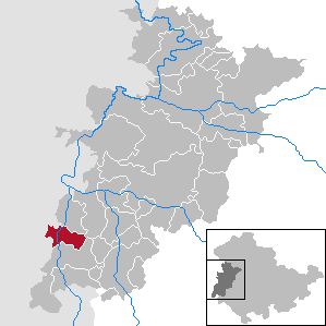
91.137.17.178 - IP Lookup: Free IP Address Lookup, Postal Code Lookup, IP Location Lookup, IP ASN, Public IP
Country:
Region:
City:
Location:
Time Zone:
Postal Code:
ISP:
ASN:
language:
User-Agent:
Proxy IP:
Blacklist:
IP information under different IP Channel
ip-api
Country
Region
City
ASN
Time Zone
ISP
Blacklist
Proxy
Latitude
Longitude
Postal
Route
db-ip
Country
Region
City
ASN
Time Zone
ISP
Blacklist
Proxy
Latitude
Longitude
Postal
Route
IPinfo
Country
Region
City
ASN
Time Zone
ISP
Blacklist
Proxy
Latitude
Longitude
Postal
Route
IP2Location
91.137.17.178Country
Region
thuringen
City
bremen
Time Zone
Europe/Berlin
ISP
Language
User-Agent
Latitude
Longitude
Postal
ipdata
Country
Region
City
ASN
Time Zone
ISP
Blacklist
Proxy
Latitude
Longitude
Postal
Route
Popular places and events near this IP address

Rasdorf
Municipality in Landkreis Fulda in Hesse, Germany
Distance: Approx. 7337 meters
Latitude and longitude: 50.71666667,9.9
Rasdorf is a municipality in the district of Fulda, in Hesse, Germany.
Geisa
Town in Thuringia, Germany
Distance: Approx. 2715 meters
Latitude and longitude: 50.71666667,9.96666667
Geisa (German pronunciation: [ˈɡaɪza] ) is a town in the Wartburgkreis district, in Thuringia, Germany. It is situated in the Rhön Mountains, 26 km northeast of Fulda. The near border with Hesse was the border between West Germany and the GDR during the Cold War.
Andenhausen
Ortsteil of Kaltennordheim in Thuringia, Germany
Distance: Approx. 7985 meters
Latitude and longitude: 50.66861111,10.07583333
Andenhausen is a village and a former municipality in the Schmalkalden-Meiningen district of Thuringia, Germany. Since 31 December 2013, it is part of the town Kaltennordheim.

Buttlar
Municipality in Thuringia, Germany
Distance: Approx. 5228 meters
Latitude and longitude: 50.75888889,9.95416667
Buttlar is a municipality in the Wartburgkreis district of Thuringia, Germany.

Dermbach
Municipality in Thuringia, Germany
Distance: Approx. 8232 meters
Latitude and longitude: 50.71638889,10.11972222
Dermbach is a municipality in the Wartburgkreis district of Thuringia, Germany. The former municipalities Brunnhartshausen, Diedorf, Neidhartshausen, Stadtlengsfeld, Urnshausen and Zella/Rhön were merged into Dermbach in January 2019.

Gerstengrund
Municipality in Thuringia, Germany
Distance: Approx. 4215 meters
Latitude and longitude: 50.7,10.05
Gerstengrund is a municipality in the Wartburgkreis district of Thuringia, Germany.
Wölferbütt
Ortsteil of Vacha in Thuringia, Germany
Distance: Approx. 6134 meters
Latitude and longitude: 50.76861111,10.05416667
Wölferbütt is a village and a former municipality in the Wartburgkreis district of Thuringia, Germany. Since 31 December 2013, it is part of the town Vacha.

Schleid
Municipality in Thuringia, Germany
Distance: Approx. 3710 meters
Latitude and longitude: 50.7,9.96666667
Schleid is a municipality in the Wartburgkreis district of Thuringia, Germany.
Rockenstuhl
Municipality in Thuringia, Germany
Distance: Approx. 8058 meters
Latitude and longitude: 50.66666667,9.93333333
Rockenstuhl is a former municipality in the Wartburgkreis district of Thuringia, Germany. It was created in March 1994 by the merger of the former municipalities Geismar, Ketten and Spahl. Since 31 December 2008, it is part of the town Geisa.

Oechsen
Municipality in Thuringia, Germany
Distance: Approx. 5321 meters
Latitude and longitude: 50.75,10.06666667
Oechsen is a municipality in the Wartburgkreis district of Thuringia, Germany. It is located 7km north west of Dermbach, close to the Baier nature reserve. It takes its name from the Oechse river.
Taft (Ulster)
River in Germany
Distance: Approx. 6472 meters
Latitude and longitude: 50.769,9.9457
Taft is a river of Hesse and Thuringia, Germany. It flows into the Ulster near Buttlar.

Bocksberg Castle
Distance: Approx. 5364 meters
Latitude and longitude: 50.69669,9.94059
Bocksberg is a levelled, medieval hilltop castle on the top of the cone-shaped hill of Bocksberg (422.5 m above NN) in the Rhön Mountains near Geisa and Schleid.
Weather in this IP's area
overcast clouds
3 Celsius
1 Celsius
0 Celsius
3 Celsius
1019 hPa
72 %
1019 hPa
969 hPa
10000 meters
2.06 m/s
4.18 m/s
225 degree
96 %
