91.132.201.22 - IP Lookup: Free IP Address Lookup, Postal Code Lookup, IP Location Lookup, IP ASN, Public IP
Country:
Region:
City:
Location:
Time Zone:
Postal Code:
IP information under different IP Channel
ip-api
Country
Region
City
ASN
Time Zone
ISP
Blacklist
Proxy
Latitude
Longitude
Postal
Route
Luminati
Country
ASN
Time Zone
Europe/Berlin
ISP
weber.digital GmbH
Latitude
Longitude
Postal
IPinfo
Country
Region
City
ASN
Time Zone
ISP
Blacklist
Proxy
Latitude
Longitude
Postal
Route
IP2Location
91.132.201.22Country
Region
schleswig-holstein
City
selk
Time Zone
Europe/Berlin
ISP
Language
User-Agent
Latitude
Longitude
Postal
db-ip
Country
Region
City
ASN
Time Zone
ISP
Blacklist
Proxy
Latitude
Longitude
Postal
Route
ipdata
Country
Region
City
ASN
Time Zone
ISP
Blacklist
Proxy
Latitude
Longitude
Postal
Route
Popular places and events near this IP address

Hedeby
Danish Viking Age trading settlement
Distance: Approx. 2719 meters
Latitude and longitude: 54.49111111,9.56527778
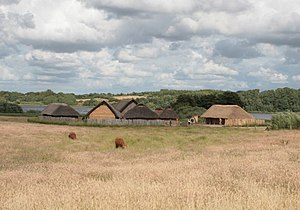
Hedeby (Danish pronunciation: [ˈhe̝ːðəˌpyˀ], Old Norse: Heiðabýr, German: Haithabu) was an important Danish Viking Age (8th to the 11th centuries) trading settlement near the southern end of the Jutland Peninsula, now in the Schleswig-Flensburg district of Schleswig-Holstein, Germany. Around 965, chronicler Abraham ben Jacob visited Hedeby and described it as, "a very large city at the very end of the world's ocean." The settlement developed as a trading centre at the head of a narrow, navigable inlet known as the Schlei, which connects to the Baltic Sea. The location was favorable because there is a short portage of less than 15 km to the Treene River, which flows into the Eider with its North Sea estuary, making it a convenient place where goods and ships could be pulled on a corduroy road overland for an almost uninterrupted seaway between the Baltic and the North Sea and avoid a dangerous and time-consuming circumnavigation of Jutland, providing Hedeby with a role similar to later Lübeck.
Haddeby
Distance: Approx. 4 meters
Latitude and longitude: 54.46666667,9.56666667
Haddeby is an Amt ("collective municipality") in the district of Schleswig-Flensburg, in Schleswig-Holstein, Germany. It is situated on the south bank of the Schlei, southeast of Schleswig. The seat of the Amt is in Busdorf.
Selk, Germany
Municipality in Schleswig-Holstein, Germany
Distance: Approx. 4 meters
Latitude and longitude: 54.46666667,9.56666667
Selk is a municipality in the district of Schleswig-Flensburg, in Schleswig-Holstein, Germany.
Geltorf
Municipality in Schleswig-Holstein, Germany
Distance: Approx. 3233 meters
Latitude and longitude: 54.46666667,9.61666667
Geltorf (Danish: Geltorp) is a municipality in the district of Schleswig-Flensburg, in Schleswig-Holstein, Germany.

Jagel
Municipality in Schleswig-Holstein, Germany
Distance: Approx. 3733 meters
Latitude and longitude: 54.45,9.51666667
Jagel (Danish: Hjagel) is a municipality in the district of Schleswig-Flensburg, in Schleswig-Holstein, Germany. Jagel is also an older German name for Jogaila.
Lottorf
Municipality in Schleswig-Holstein, Germany
Distance: Approx. 1859 meters
Latitude and longitude: 54.45,9.56666667
Lottorf (Danish: Lottorp) is a municipality in the district of Schleswig-Flensburg, in Schleswig-Holstein, Germany.

Taktisches Luftwaffengeschwader 51
Military unit
Distance: Approx. 3357 meters
Latitude and longitude: 54.4593,9.5164
Taktisches Luftwaffengeschwader 51 "Immelmann" (Tactical Air Force Wing 51 "Immelmann"), formerly known as Aufklärungsgeschwader 51 ("Reconnaissance Wing 51"), is a tactical reconnaissance wing of the German Air Force. In the beginning of the 1990s, the German Air Force disbanded its two reconnaissance air wings (Aufklärungsgeschwader 51 in Bremgarten and Aufklärungsgeschwader 52 in Leck) and phased out their McDonnell Douglas RF-4E Phantoms. At the same time, the German Navy made the decision to disband one of its two Panavia Tornado fighter-bomber wings.

Hedeby Viking Museum
Museum in Busdorf, Germany
Distance: Approx. 3377 meters
Latitude and longitude: 54.497,9.5694
The Hedeby Viking Museum (German: Wikinger Museum Haithabu) is a museum near the site of Hedeby, a former medieval city in Schleswig-Holstein, Germany focusing on the Viking Age history of the region. While the region is now in modern Germany, it was once the oldest city in Denmark until it was ceded in 1864. The museum, located in the Busdorf municipality, features reconstructions of various Viking Age dwellings and ships and houses numerous artifacts discovered during the ongoing archaeological research of the area.

Haddebyer Noor
Distance: Approx. 3007 meters
Latitude and longitude: 54.49333333,9.57444444
Haddebyer Noor (Danish: Haddeby Nor or Hedeby Nor) is a lake – formerly a small arm of the Schlei inlet of the Baltic Sea – in Schleswig-Holstein, Germany. At an elevation of 0 m (0 ft), its surface area is one km2 (0.39 sq mi).

Selker Noor
Distance: Approx. 1681 meters
Latitude and longitude: 54.48027778,9.57805556
Selker Noor (Danish: Selk Nor) is a lake in Schleswig, Schleswig-Holstein, Germany. At an elevation of 0 m, its surface area is 0.558 km2.

Schleswig Air Base
Airbase of the German Air Force
Distance: Approx. 3354 meters
Latitude and longitude: 54.45944444,9.51638889
Schleswig Air Base is an airbase of the German Air Force, home to Taktisches Luftwaffengeschwader 51 (Tactical Air Force Wing 51) "Immelmann" (AKG 51) flying reconnaissance variants of the Panavia Tornado. It was formerly known from c.1945-1958 as RAF Schleswigland in Royal Air Force (RAF) use.

Battle for Königshügel
Battle of the Second Schleswig War
Distance: Approx. 1195 meters
Latitude and longitude: 54.4773,9.5638
The Battle of Königshügel (Danish: Kampene ved Kongshøj), also known as the Battle of Ober-Selk was a battle in the Second Schleswig War where Austrian Major General Gondrecourt and his infantry brigade succeeded in occupying the area in front of the Danevirke near Ober-Selk (Danish: Øvre Selk) and taking the strategically important village of Königshügel (Danish: Kongshøj).
Weather in this IP's area
overcast clouds
5 Celsius
4 Celsius
4 Celsius
6 Celsius
1035 hPa
97 %
1035 hPa
1033 hPa
2800 meters
1.54 m/s
180 degree
100 %


