Country:
Region:
City:
Latitude and Longitude:
Time Zone:
Postal Code:
IP information under different IP Channel
ip-api
Country
Region
City
ASN
Time Zone
ISP
Blacklist
Proxy
Latitude
Longitude
Postal
Route
Luminati
Country
Region
cb
City
saron
ASN
Time Zone
Europe/Madrid
ISP
Adamo Telecom Iberia S.A.
Latitude
Longitude
Postal
IPinfo
Country
Region
City
ASN
Time Zone
ISP
Blacklist
Proxy
Latitude
Longitude
Postal
Route
db-ip
Country
Region
City
ASN
Time Zone
ISP
Blacklist
Proxy
Latitude
Longitude
Postal
Route
ipdata
Country
Region
City
ASN
Time Zone
ISP
Blacklist
Proxy
Latitude
Longitude
Postal
Route
Popular places and events near this IP address

Riotuerto
Municipality in Cantabria, Spain
Distance: Approx. 3409 meters
Latitude and longitude: 43.35333333,-3.70472222
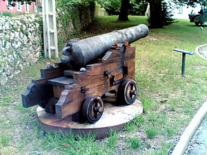
Riotuerto (Rutuertu in Cantabrian) is one of the municipalities of Cantabria, lying between the North Coast of the Cantábrican Sea and the mountains of the Cantabrian Sierra. It is part of the ancient merindad (shire) of Trasmiera. The centre of Riotuerto is La Cavada, once the home of the famed Royal Artillery Factory and now the site of the Town Hall, library and cannon museum.

Trasmiera
Comarca in Cantabria, Spain
Distance: Approx. 6832 meters
Latitude and longitude: 43.41111111,-3.60916667
Trasmiera (Spanish: Trasmiera; Cantabrian and historically: Tresmiera) is a historic comarca of Cantabria (Spain), located to the east of the Miera River (tras Miera, meaning behind Miera, from the point of view of Asturias de Santillana), reaching the western side of the Asón. It extends between the bays of Santander and Santoña, occupying most of the Eastern seaboard of Cantabria. This piece of coast is known for its cliffs and fine beaches, such as those of Langre, Loredo, Isla, Noja and Berria.

Entrambasaguas
Municipality in Cantabria, Spain
Distance: Approx. 338 meters
Latitude and longitude: 43.37777778,-3.67666667
Entrambasaguas is a small municipality located in the autonomous community of Cantabria, Spain, 25 km south of the Bay of Santander. It is moderately mountainous, and the origin of the Aguanaz River, which once drove 23 watermills and merges with the Miera River. Limestone caves with Paleolithic rock art and burial sites from the Bronze Age exist.

Hazas de Cesto
Municipality in Cantabria, Spain
Distance: Approx. 7643 meters
Latitude and longitude: 43.39694444,-3.58972222
Hazas de Cesto is a municipality located in the autonomous community of Cantabria, Spain. According to the 2007 census, the city has a population of 1,285 inhabitants. Its capital is Beranga.

Liérganes
Municipality in Cantabria, Spain
Distance: Approx. 6262 meters
Latitude and longitude: 43.34333333,-3.74111111
Liérganes is a municipality located in the autonomous community of Cantabria, Spain. According to the 2007 census, the city has a population of 2,391 inhabitants.
Marina de Cudeyo
Municipality in Cantabria, Spain
Distance: Approx. 7564 meters
Latitude and longitude: 43.42055556,-3.75416667
Marina de Cudeyo is a municipality located in the autonomous community of Cantabria, Spain. According to the 2007 census, the city has a population of 5,000 inhabitants. Its capital is Rubayo.
SD Solares-Medio Cudeyo
Association football club in Spain
Distance: Approx. 4279 meters
Latitude and longitude: 43.387807,-3.732042
Sociedad Deportiva Solares-Medio Cudeyo is a football team based in Solares, Medio Cudeyo in the autonomous community of Cantabria. Founded in 1968, the team plays in Regional Preferente. The club plays its home games at La Estación, which has artificial turf, capacity of 1,500 spectators and a stadium bar.
Ceceñas
Place in Cantabria, Spain
Distance: Approx. 2915 meters
Latitude and longitude: 43.37361111,-3.71611111
Ceceñas is a community in Cantabria, Spain. It is located 1.8 kilometres (1.1 mi) from Valdecilla and 19.6 kilometres (12.2 mi) from Santander. Ceceñas is the birthplace of the architect Jerónimo de la Gándara (1825-1877).

Royal Artillery Factory of La Cavada
Distance: Approx. 3718 meters
Latitude and longitude: 43.3519,-3.7085
The Royal Artillery Factory of La Cavada (Spanish: Real Fábrica de Artillería de La Cavada) was an artillery foundry at La Cavada (Riotuerto) in Cantabria, Northern Spain. The foundry was established in 1622 by Jean Curtius with the support of Gaspar de Guzmán, Count-Duke of Olivares and became fully operational 15 years later. Between 1637 and 1835 the facility was responsible for the production of more than 26,000 cannons for ships and fortresses throughout the Spanish Empire.

Medio Cudeyo
Municipality in Cantabria, Spain
Distance: Approx. 4137 meters
Latitude and longitude: 43.3814,-3.7317
Medio Cudeyo is a municipality in Cantabria in Spain, around 15 km from Santander.
Solórzano
Place in Cantabria, Spain
Distance: Approx. 7690 meters
Latitude and longitude: 43.38694444,-3.58638889
Solórzano is a municipality in Cantabria, Spain.

La Garma cave complex
Cave complex and archaeological site with prehistoric paintings in Spain
Distance: Approx. 5919 meters
Latitude and longitude: 43.43055556,-3.66583333
The La Garma cave complex is a parietal art-bearing paleoanthropological cave system in Cantabria, Spain. It is located just north of the village of Omoño, part of the municipality of Ribamontán al Monte. The cave complex is noted for one of the best preserved floors from the Paleolithic containing more than 4,000 fossils and more than 500 graphical units.
Weather in this IP's area
clear sky
11 Celsius
10 Celsius
9 Celsius
12 Celsius
1021 hPa
86 %
1021 hPa
1016 hPa
10000 meters
2.06 m/s
100 degree
08:08:34
17:50:25

