Country:
Region:
City:
Latitude and Longitude:
Time Zone:
Postal Code:
IP information under different IP Channel
ip-api
Country
Region
City
ASN
Time Zone
ISP
Blacklist
Proxy
Latitude
Longitude
Postal
Route
Luminati
Country
ASN
Time Zone
Europe/Madrid
ISP
Adamo Telecom Iberia S.A.
Latitude
Longitude
Postal
IPinfo
Country
Region
City
ASN
Time Zone
ISP
Blacklist
Proxy
Latitude
Longitude
Postal
Route
db-ip
Country
Region
City
ASN
Time Zone
ISP
Blacklist
Proxy
Latitude
Longitude
Postal
Route
ipdata
Country
Region
City
ASN
Time Zone
ISP
Blacklist
Proxy
Latitude
Longitude
Postal
Route
Popular places and events near this IP address
Proaza
Municipality in Asturias, Spain
Distance: Approx. 1339 meters
Latitude and longitude: 43.25,-6
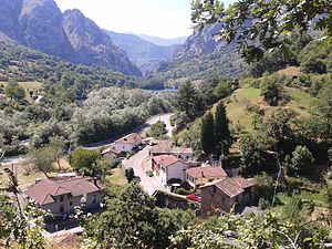
Proaza is a municipality in the Autonomous Community of the Principality of Asturias, Spain. It is bordered on the north by Santo Adriano and Grado, on the south by Teverga and Quirós, on the west by Yernes y Tameza and Teverga, and on the east by Quirós.

Llavares
Distance: Approx. 6254 meters
Latitude and longitude: 43.29042,-5.9603
Llavares is a parish in Santo Adriano, a municipality within the province and autonomous community of Asturias, in northern Spain. The elevation is 440 m (1,440 ft) above sea level. It is 3.67 km2 (1.42 sq mi) in size.

Banduxu
Parish in Asturias, Spain
Distance: Approx. 5720 meters
Latitude and longitude: 43.22006389,-6.07179167
Banduxu is one of eight parishes in Proaza, a municipality within the province and autonomous community of Asturias, in northern Spain. It is 10.78 km2 (4.16 sq mi) in size with a population of 43 (INE 2005). The postal code is 33114.
Caranga
Distance: Approx. 4147 meters
Latitude and longitude: 43.216667,-6.033333
Caranga is one of eight parishes in Proaza, a municipality within the province and autonomous community of Asturias, in northern Spain. It is 14.32 km2 (5.53 sq mi) in size with a population of 87 (INE 2005).

Llinares
Distance: Approx. 3452 meters
Latitude and longitude: 43.2824,-6.0232
Llinares is one of eight parishes in Proaza, a municipality within the province and autonomous community of Asturias, in northern Spain. It is 4.34 km2 (1.68 sq mi) in size with a population of 28 (INE 2005). The postal code is 33114.

Proacina
Distance: Approx. 2737 meters
Latitude and longitude: 43.25,-6.05
Proacina is one of eight parishes in Proaza, a municipality within the province and autonomous community of Asturias, in northern Spain. It is 5.14 km2 (1.98 sq mi) in size, with a population of 19 (INE 2005).

San Martín (Proaza)
Distance: Approx. 3350 meters
Latitude and longitude: 43.24693889,-5.97555278
San Martín is one of eight parishes in Proaza, a municipality within the province and autonomous community of Asturias, in northern Spain. It is 14.1 km2 (5.4 sq mi) in size with a population of 138 (INE 2005).
Santo Adriano del Monte
Parish in Asturias, Spain
Distance: Approx. 5301 meters
Latitude and longitude: 43.287778,-6.059167
Santo Adriano del Monte is one of 28 parishes (administrative divisions) in the municipality of Grado, within the province and autonomous community of Asturias, in northern Spain.

Las Agüeras
Distance: Approx. 6170 meters
Latitude and longitude: 43.196389,-6.014444
Las Agüeras is one of thirteen parishes (administrative divisions) in Quirós, a municipality within the province and autonomous community of the Principality of Asturias, in northern Spain. The population is 162 (INE 2010).

Pedroveya
Distance: Approx. 4353 meters
Latitude and longitude: 43.266667,-5.966667
Pedroveya is one of thirteen parishes (administrative divisions) in Quirós, a municipality within the province and autonomous community of the Principality of Asturias, in northern Spain. The population is 30.

Church of Santo Adriano de Tuñón
Distance: Approx. 5300 meters
Latitude and longitude: 43.29163889,-5.98052778
The Church of Santo Adriano de Tuñón (Spanish: Iglesia de Santo Adriano de Tuñón) is a Roman Catholic Pre-Romanesque church in the village of Tuñón, Asturias, Spain dedicated to Saint Adrian. The church is located on the bank of the River Trubia, next to an old Roman road. Founded on January 24, 891, by Alfonso III of Asturias and his wife Jimena of Navarra as a monastery church, it went through large transformations at the beginnings of the 12th century.

Bermiego Yew
Distance: Approx. 6232 meters
Latitude and longitude: 43.20093,-5.984258
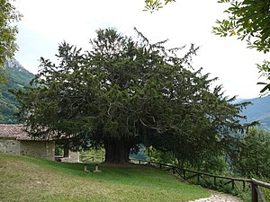
Bermiego Yew, also called in Asturias "Teixu l'Ilesia" is an ancient tree of the species Taxus baccata growing in the village of Bermiego in the Principality of Asturias, northern Spain on the western slope of the Sierra del Aramo. The tree can be found just outside the village within the precincts of the village chapel of Santa Maria de Bermiego. The morphology of the Bermiego Yew is almost perfect.
Weather in this IP's area
broken clouds
10 Celsius
9 Celsius
9 Celsius
10 Celsius
1020 hPa
98 %
1020 hPa
994 hPa
10000 meters
2.09 m/s
2.1 m/s
180 degree
63 %
08:17:35
18:00:05
