Country:
Region:
City:
Latitude and Longitude:
Time Zone:
Postal Code:
IP information under different IP Channel
ip-api
Country
Region
City
ASN
Time Zone
ISP
Blacklist
Proxy
Latitude
Longitude
Postal
Route
Luminati
Country
ASN
Time Zone
Europe/Madrid
ISP
Adamo Telecom Iberia S.A.
Latitude
Longitude
Postal
IPinfo
Country
Region
City
ASN
Time Zone
ISP
Blacklist
Proxy
Latitude
Longitude
Postal
Route
db-ip
Country
Region
City
ASN
Time Zone
ISP
Blacklist
Proxy
Latitude
Longitude
Postal
Route
ipdata
Country
Region
City
ASN
Time Zone
ISP
Blacklist
Proxy
Latitude
Longitude
Postal
Route
Popular places and events near this IP address

Buñuel
Distance: Approx. 6232 meters
Latitude and longitude: 41.98138889,-1.44083333
Buñuel is a town and municipality located in the province and autonomous community of Navarre, northern Spain.

Cabanillas
Town and municipality in Navarre, Spain
Distance: Approx. 3888 meters
Latitude and longitude: 42.03138889,-1.52694444
Cabanillas (very exceptionally in Basque: Kapanaga) is a town and municipality located in the province and autonomous community of Navarre, northern Spain.
Fontellas
Distance: Approx. 4918 meters
Latitude and longitude: 42.01666667,-1.56666667
Fontellas is a town and municipality located in the province and autonomous community of Navarre, northern Spain.The town and municipality is linked to the Marquisate of Fontellas.

Fustiñana
Town and municipality in northern Spain
Distance: Approx. 3191 meters
Latitude and longitude: 42.01666667,-1.48333333
Fustiñana is a town and municipality located in the province and autonomous community of Navarre, northern Spain.

Ribaforada
Place in Navarre, Spain
Distance: Approx. 1073 meters
Latitude and longitude: 42,-1.5
Ribaforada is a town and municipality located in the province and autonomous community of Navarre, northern Spain. Their football team is the Club Deportivo Ribaforada.
Battle of Estercuel
10th-century battle in Muslim Iberia
Distance: Approx. 1136 meters
Latitude and longitude: 42.008304,-1.512472
The Battle of Estercuel took place on 6 July 975 between the forces of the Kingdom of Viguera, under king Ramiro Garcés, and those of the Caliphate of Córdoba, under the kaid of Zaragoza, al-Tuyibi. The battle, a typical skirmish of the Christian–Muslim frontier, was a victory for the Caliphate. Several leading Navarrese magnates were killed and Ramiro was injured.

Tudela de Navarra railway station
Distance: Approx. 9793 meters
Latitude and longitude: 42.0593,-1.5978
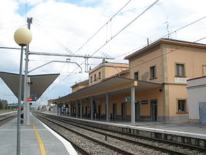
Estación de Tudela de Navarra is a railway and bus station in the Spanish city of Tudela in the autonomous region of Navarre. It was first opened in May 1861.
Weather in this IP's area
few clouds
11 Celsius
10 Celsius
11 Celsius
11 Celsius
1022 hPa
82 %
1022 hPa
991 hPa
10000 meters
2.21 m/s
2.26 m/s
126 degree
12 %
07:56:24
17:45:14
