Country:
Region:
City:
Latitude and Longitude:
Time Zone:
Postal Code:
IP information under different IP Channel
ip-api
Country
Region
City
ASN
Time Zone
ISP
Blacklist
Proxy
Latitude
Longitude
Postal
Route
Luminati
Country
ASN
Time Zone
Europe/Madrid
ISP
Adamo Telecom Iberia S.A.
Latitude
Longitude
Postal
IPinfo
Country
Region
City
ASN
Time Zone
ISP
Blacklist
Proxy
Latitude
Longitude
Postal
Route
db-ip
Country
Region
City
ASN
Time Zone
ISP
Blacklist
Proxy
Latitude
Longitude
Postal
Route
ipdata
Country
Region
City
ASN
Time Zone
ISP
Blacklist
Proxy
Latitude
Longitude
Postal
Route
Popular places and events near this IP address

La Pau (Barcelona Metro)
Metro station in Barcelona, Spain
Distance: Approx. 742 meters
Latitude and longitude: 41.42305556,2.20527778
La Pau is a Barcelona metro station located in the neighbourhood of the same name, in the Sant Martí district. The station is located underground of Carrer Guipúscoa and Carrer Ca n'Oliva. It was opened in 1982 (1982), serving then as the terminus of L4, which had just been extended to La Pau from Selva de Mar.

Sant Martí (Barcelona Metro)
Metro station in Barcelona, Spain
Distance: Approx. 107 meters
Latitude and longitude: 41.4175,2.19833333
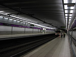
Sant Martí is the name of a Barcelona metro station located in the Sant Martí district of the city, opened in 1997. It is located under Carrer de Guipúscoa, between Carrer Agricultura and Carrer Cantàbria, with an access on each side. The station is served by L2 and is fully adapted for disabled people.
Sagrera railway station
Railway station in Barcelona, Spain
Distance: Approx. 621 meters
Latitude and longitude: 41.42166667,2.19361111
Sagrera railway station (Catalan: Estació de la Sagrera, Spanish: Estación de la Sagrera) is a major through station under construction in the Barcelona districts of Sant Andreu and Sant Martí, in Catalonia, Spain. It is intended to serve as the central station for northern and eastern Barcelona, with Sants serving as the central station for southern and western Barcelona. It will add a high-speed hub to the current two stations on the Madrid–Barcelona high-speed rail line, El Prat de Llobregat and Sants.

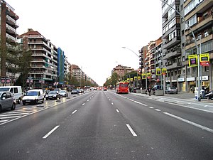
Avinguda Meridiana
Distance: Approx. 1126 meters
Latitude and longitude: 41.42194167,2.18684722
Avinguda Meridiana (Catalan pronunciation: [əβiŋˈɡuðə məɾiðiˈanə]) is a major avenue in Barcelona, Catalonia, Spain, spanning parts of the Sant Andreu, Nou Barris and Sant Martí northern districts of the city. Originally planned by Ildefons Cerdà in 1859 to be one of the two most important thoroughfares in Barcelona, its actual role has not been exactly so but still has become a much transited route linking Parc de la Ciutadella with northern parts of Barcelona, crossing Plaça de les Glòries in its way, where it meets other two major avenues: Gran Via de les Corts Catalanes and Avinguda Diagonal. It absorbs the traffic coming from the AP-7 motorway, which makes it a densely transited area.

Bac de Roda station
Metro station in Barcelona, Spain
Distance: Approx. 675 meters
Latitude and longitude: 41.41361111,2.19388889
Bac de Roda is a station on line 2 of the Barcelona Metro. The station is located underneath Carrer Guipúscoa, between Carrer Bac de Roda and Carrer Fluvià, and about 100 metres (330 ft) south of the iconic Bac de Roda Bridge. The side-platform station has an access at either end.
Besòs (Barcelona Metro)
Metro station in Barcelona, Spain
Distance: Approx. 862 meters
Latitude and longitude: 41.42016111,2.20928333
Besòs (Catalan pronunciation: [bəˈzɔs]) is a station of the Barcelona Metro, served by L4 (yellow line). It takes its name from the Besòs neighbourhood of Barcelona (named after the river Besòs), in the Sant Martí district. The station is located in the intersection of Gran Via de les Corts Catalanes, Carretera de Mataró and Rambla de Prim.

Navas (Barcelona Metro)
Metro station in Barcelona, Spain
Distance: Approx. 1072 meters
Latitude and longitude: 41.41555556,2.18694444
Navas is a Barcelona Metro station located in the Navas neighborhood, Sant Andreu district of Barcelona. It is served by L1. It opened in 1953.

Sant Martí de Provençals
Neighborhood of Barcelona in Catalonia, Spain
Distance: Approx. 144 meters
Latitude and longitude: 41.41722222,2.19805556
Sant Martí de Provençals is a neighborhood in the Sant Martí district of Barcelona, Catalonia (Spain). Sant Martí de Provençals was the center of the eponymous former municipality, which now more or less coincides with the current district of Sant Martí and which gave its name to the main core of the town. Until the 1950s the area was occupied by fields, country houses and the church of Sant Martí.
Provençals del Poblenou
Neighbourhood of Barcelona in Catalonia, Spain
Distance: Approx. 974 meters
Latitude and longitude: 41.4094,2.20056
Provençals del Poblenou is a neighborhood in the Sant Martí district of Barcelona, Catalonia (Spain).

Navas, Sant Andreu
Distance: Approx. 1070 meters
Latitude and longitude: 41.41574444,2.1869
Navas, unofficially known as Torrent de la Guineu, is a neighborhood in the Sant Andreu district of Barcelona, Catalonia (Spain). The Avinguda Meridiana is spanning the neighborhood. Its population as of 1 January 2016 was 22,100 people on a land area of 0.42 km2 (0.16 sq mi).

Bac de Roda Bridge
Bridge in Catalonia, Spain
Distance: Approx. 611 meters
Latitude and longitude: 41.416191,2.192464
The Bac de Roda Bridge, known locally as the Calatrava bridge, is a road bridge that links the districts of Sant Andreu and Sant Martí in the city of Barcelona, Catalonia, Spain. The bridge was constructed between 1984 and 1987, to a design by Santiago Calatrava, as part of the preparations for the 1992 Summer Olympics. The bridge connects the Carrer de Bac de Roda, to the south in Sant Martí, with the Carrer de Felip II, to the north in Sant Andreu, across the main railway approaches to Barcelona from the north.

Biblioteca Gabriel García Márquez
Public library in Barcelona, Spain
Distance: Approx. 113 meters
Latitude and longitude: 41.41722222,2.2
The Biblioteca Gabriel García Márquez is a public library located in Sant Martí de Provençals, a neighborhood of Barcelona. It was inaugurated on 28 May 2022. It specializes in Latin American literature and is named after the Colombian writer Gabriel García Márquez, who lived in the Catalan capital between 1967 and 1975, where he wrote The Autumn of the Patriarch (El otoño del patriarca).
Weather in this IP's area
overcast clouds
14 Celsius
13 Celsius
12 Celsius
15 Celsius
1023 hPa
74 %
1023 hPa
1021 hPa
10000 meters
2.06 m/s
330 degree
100 %
07:40:08
17:31:49
