91.126.236.14 - IP Lookup: Free IP Address Lookup, Postal Code Lookup, IP Location Lookup, IP ASN, Public IP
Country:
 Spain
SpainRegion:
City:
Location:
Time Zone:
Postal Code:
ISP:
ASN:
language:
User-Agent:
Proxy IP:
Blacklist:
IP information under different IP Channel
ip-api
Country
Region
City
ASN
Time Zone
ISP
Blacklist
Proxy
Latitude
Longitude
Postal
Route
db-ip
Country
Region
City
ASN
Time Zone
ISP
Blacklist
Proxy
Latitude
Longitude
Postal
Route
IPinfo
Country
Region
City
ASN
Time Zone
ISP
Blacklist
Proxy
Latitude
Longitude
Postal
Route
IP2Location
91.126.236.14Country
esRegion
cantabria
City
los corrales de buelna
Time Zone
Europe/Madrid
ISP
Language
User-Agent
Latitude
Longitude
Postal
ipdata
Country
Region
City
ASN
Time Zone
ISP
Blacklist
Proxy
Latitude
Longitude
Postal
Route
Popular places and events near this IP address

CD Tropezón
Association football club in Spain
Distance: Approx. 7702 meters
Latitude and longitude: 43.330304,-4.047338
Club Deportivo Tropezón is a football team based in Tanos, Torrelavega in the autonomous community of Cantabria. Founded in 1983, it plays in the Tercera Federación – Group 3. Its stadium is Santa Ana with a capacity of 1,500 seats.

Cave of La Pasiega
Cave with prehistoric paintings in Spain
Distance: Approx. 9121 meters
Latitude and longitude: 43.28888889,-3.96555556
Cueva de La Pasiega, or Cave of La Pasiega, situated in the Spanish municipality of Puente Viesgo, is one of the most important monuments of Paleolithic art in Cantabria. It is included in the UNESCO World Heritage List since July 2008, as part of the inscription: Cave of Altamira and Paleolithic Cave Art of Northern Spain. The cave is located in the heart of the uniprovincial community, in the middle of the Pas River valley, around the cave of Hornos de la Pena and Monte Castillo, in the same group of caves as Las Monedas, Las Chimeneas, and the cave of El Castillo.

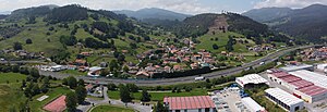
Los Corrales de Buelna
Municipality in Cantabria, Spain
Distance: Approx. 631 meters
Latitude and longitude: 43.26166667,-4.06527778
Los Corales de Buelna is a municipality in Cantabria, Spain.

Besaya Valley
Comarca in Cantabria, Spain
Distance: Approx. 2072 meters
Latitude and longitude: 43.26583333,-4.04722222
The Besaya valley (Spanish: Valle del Besaya) is both a comarca located in the center of Cantabria, along the course of the Besaya River, and the natural valley of said river. Its capital is Torrelavega.

Anievas
Municipality in Cantabria, Spain
Distance: Approx. 8920 meters
Latitude and longitude: 43.20305556,-4.00055556
Anievas is a municipality located in the autonomous community of Cantabria, Spain. According to the 2007 census, the city has a population of 12.919 inhabitants. Its capital is Cotillo.

Cartes
Municipality in Cantabria, Spain
Distance: Approx. 6907 meters
Latitude and longitude: 43.32555556,-4.06805556
Cartes is a municipality located in the autonomous community of Cantabria, Spain. According to the 2009 census, the city has a population of 5.118 inhabitants.
San Mateo (Cantabria)
Distance: Approx. 1160 meters
Latitude and longitude: 43.27305556,-4.07861111
San Mateo is a village in the municipality of Los Corrales de Buelna in the autonomous community of Cantabria, Spain. The Rebujas runs through it. It is bordered to the north by Barros, to the south-east by Los Corrales de Buelna and the west by Saja-Besaya Natural Park.
Bostronizo
Distance: Approx. 7763 meters
Latitude and longitude: 43.2,-4.03333333
Bostronizo is a town in the Arenas de Iguña municipality of the Spanish region of Cantabria. In the year 2004 its population was 137. Bostronizo is located 2.8 kilometers (1.7 mi) from the capital of the municipality, Arenas de Iguña, and 425 meters (1,394 feet) above sea level.
Cohiño
Town in Cantabria, Spain
Distance: Approx. 8043 meters
Latitude and longitude: 43.19138889,-4.07583333
Cohiño is a town in the Arenas de Iguña municipality of the Spanish region of Cantabria. Locally the town is also known as Palazuelos. In the year 2004 the population of Cohiño was 71.
Los Llares
Distance: Approx. 9208 meters
Latitude and longitude: 43.18333333,-4.1
Los Llares is a town in the Arenas de Iguña municipality of the Spanish region of Cantabria. In the year 2004 the population of los Llares was 45. The town is located 5.1 kilometers (3.2 mi) from the capital of the municipality, Arenas de Iguña, and 245 meters (804 feet) above sea level.
San Cristóbal, Cantabria
Distance: Approx. 7891 meters
Latitude and longitude: 43.19277778,-4.07666667
San Cristóbal is a town in the Arenas de Iguña municipality of the Spanish region of Cantabria. The town is also known as Valdeiguña. In the year 2004 its population was 181.
San Vicente de León
Distance: Approx. 8978 meters
Latitude and longitude: 43.18333333,-4.08333333
San Vicente de León is a town in the Arenas de Iguña municipality of the Spanish region of Cantabria. The town, which included 51 residences as of 2004, is located on a hilltop 4.5 kilometers (2.8 mi) west of the capital of the municipality, Arenas de Iguña, and 449 meters (1,473 feet) above sea level.
Weather in this IP's area
overcast clouds
10 Celsius
10 Celsius
8 Celsius
10 Celsius
1016 hPa
89 %
1016 hPa
975 hPa
10000 meters
2.51 m/s
3.53 m/s
179 degree
100 %