91.126.216.254 - IP Lookup: Free IP Address Lookup, Postal Code Lookup, IP Location Lookup, IP ASN, Public IP
Country:
 Spain
SpainRegion:
City:
Location:
Time Zone:
Postal Code:
ISP:
ASN:
language:
User-Agent:
Proxy IP:
Blacklist:
IP information under different IP Channel
ip-api
Country
Region
City
ASN
Time Zone
ISP
Blacklist
Proxy
Latitude
Longitude
Postal
Route
db-ip
Country
Region
City
ASN
Time Zone
ISP
Blacklist
Proxy
Latitude
Longitude
Postal
Route
IPinfo
Country
Region
City
ASN
Time Zone
ISP
Blacklist
Proxy
Latitude
Longitude
Postal
Route
IP2Location
91.126.216.254Country
esRegion
catalunya
City
llers
Time Zone
Europe/Madrid
ISP
Language
User-Agent
Latitude
Longitude
Postal
ipdata
Country
Region
City
ASN
Time Zone
ISP
Blacklist
Proxy
Latitude
Longitude
Postal
Route
Popular places and events near this IP address

Battle of Sant Llorenç de la Muga
Distance: Approx. 2707 meters
Latitude and longitude: 42.3158,2.9303
The Battle of Sant Llorenç de la Muga (in Catalan, in Spanish: San Lorenzo de la Muga) was fought on 13 August 1794 between an attacking Spanish–Portuguese army led by the Conde de la Unión and a French army commanded by Jacques François Dugommier. The local French defenders headed by Pierre Augereau and Dominique Pérignon repulsed the allies. The Spanish garrison of Fort de Bellegarde surrendered a month later.

Alt Empordà
Comarca in Catalonia, Spain
Distance: Approx. 1944 meters
Latitude and longitude: 42.2881,2.93306
Alt Empordà (Catalan: [ˈal əmpuɾˈða]; Spanish: Alto Ampurdán; "Upper Empordà") is a comarca (county) located in the Girona region, in Catalonia, Spain. It is one of two comarques into which Empordà was divided by the comarca division of Catalonia in 1936, the other one being Baix Empordà. The capital is the municipality of Figueres.

Vilanant
Municipality in Catalonia, Spain
Distance: Approx. 4977 meters
Latitude and longitude: 42.254,2.89
Vilanant (Catalan pronunciation: [ˌbiləˈnan]) is a town in the Alt Empordà comarca, in Girona, Catalonia, Spain. It has a population of 328 people. The municipality covers an area of 17 km² and is located at an average altitude of 98 meters above sea level.

Muga (river)
Distance: Approx. 2434 meters
Latitude and longitude: 42.31376389,2.92845556
The Muga (Catalan pronunciation: [ˈmuɣə]) is a river in Catalonia, Spain, that rises in the mountains of the eastern Pyrenees. It enters the Mediterranean Sea at the Gulf of Roses. The river is 58 kilometres (36 mi) long.

Gala-Salvador Dalí Foundation
Cultural institution founded by Salvador Dalí
Distance: Approx. 4968 meters
Latitude and longitude: 42.268,2.9591
The Gala-Salvador Dalí Foundation (Catalan: Fundació Gala-Salvador Dalí; Spanish: Fundación Gala-Salvador Dalí) is a private cultural institution founded by the painter Salvador Dalí with the mission of promoting his artistic, cultural and intellectual œuvre. It is also named after his wife, Gala Dalí. Although the Foundation manages the assets, trademark rights, intellectual property and image of the painter, it is not its owner, since Dalí bequeathed all of his assets to the Spanish State in his last will.
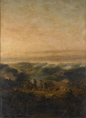
Battle of the Black Mountain
Distance: Approx. 2707 meters
Latitude and longitude: 42.3158,2.9303
The Battle of the Black Mountain (also Capmany or Sierra Negra or Del Roure or Montroig) was fought from 17 to 20 November 1794 between the army of the First French Republic and the allied armies of the Kingdom of Spain and the Kingdom of Portugal. The French, led by Jacques François Dugommier defeated the Allies, who were commanded by Luis Firmín de Carvajal, Conde de la Unión. Though the Spanish right wing held, its left flank was driven back on the first day's fighting.

Rissec
River in Spain
Distance: Approx. 4306 meters
Latitude and longitude: 42.25701667,2.91150278
The Rissec (Catalan pronunciation: [riˈsɛk], lit. 'dry river') is a tributary river from the Empordà which lies to the west of the Daró river. Originating in Gavarres Mountains in the Els Àngels region, it empties into the Daró river in the municipality Corçà. During its course it is fed by the water from the Rodonell river and the Sant Pere creek.
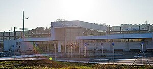
Figueres–Vilafant railway station
Building in Girona Province, Spain
Distance: Approx. 4188 meters
Latitude and longitude: 42.26555556,2.94222222
Figueres–Vilafant is a railway station serving the city of Figueres in Catalonia, Spain. It is located in the municipality of Vilafant, at about 2 kilometres (1.2 mi) west from its urban center and 1.5 kilometres (0.93 mi) from Figueres city centre. The station is on the Perpignan–Barcelona high-speed rail line and is served by Renfe Operadora's AVE and SNCF's TGV high-speed trains.

Sant Ferran Castle
Distance: Approx. 3763 meters
Latitude and longitude: 42.27361111,2.94638889
The Sant Ferran Castle (Catalan: Castell de Sant Ferran) is situated on a hill in Figueres, Catalonia at the end of Pujada del Castell. It is a large military fortress built in the eighteenth century under the orders of several military engineers, including Pedro Martín Cermeño and Juan Martín Cermeño. It is the largest monument in Catalonia.
Rainy Taxi
Sculpture by Salvador Dalí
Distance: Approx. 4981 meters
Latitude and longitude: 42.2681,2.9594
Rainy Taxi, also known as Mannequin Rotting in a Taxi-Cab, is a three-dimensional artwork created by Salvador Dalí, in 1938, consisting of an actual automobile with two mannequin occupants.
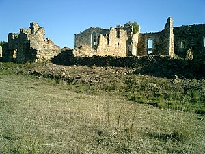
Monastery of Santa Maria del Roure
Distance: Approx. 3180 meters
Latitude and longitude: 42.324263,2.911191
The monastery of Santa Maria del Roure, referred to as El Roure by locals, is a ruined monastery to the northwest of Pont de Molins (Alt Empordà, Catalonia) at the top of the Serra dels Tramonts. Mostly Gothic-era portions of the building are preserved. Dedicated to the Virgin Mary, the various names of the sanctuary -Santa Maria del Roure, Canònica de Santa Maria del Roure, Monastery of Santa Maria del Roure, or according to the Cartographic Institute of Catalonia: Mare de Déu del Roure- date from the 11th or early 12th century.
First Battle of Sant Llorenç de la Muga
Distance: Approx. 2707 meters
Latitude and longitude: 42.3158,2.9303
The First Battle of Sant Llorenç de la Muga (Catalan) or Spanish: San Lorenzo de la Muga) (19 May 1794) between a Spanish army commanded by the Luis Firmín de Carvajal, Conde de la Unión and a French army led by Jacques François Dugommier. Two weeks earlier, the French had driven the Spanish army from French territory in the Second Battle of Boulou. Pierre Augereau's division was separated from the main body of Dugommier's army and La Unión hoped to take advantage of its isolation.
Weather in this IP's area
clear sky
5 Celsius
3 Celsius
3 Celsius
6 Celsius
1032 hPa
78 %
1032 hPa
1009 hPa
10000 meters
2.24 m/s
3.58 m/s
241 degree