Country:
Region:
City:
Latitude and Longitude:
Time Zone:
Postal Code:
IP information under different IP Channel
ip-api
Country
Region
City
ASN
Time Zone
ISP
Blacklist
Proxy
Latitude
Longitude
Postal
Route
Luminati
Country
Region
ct
City
barcelona
ASN
Time Zone
Europe/Madrid
ISP
Adamo Telecom Iberia S.A.
Latitude
Longitude
Postal
IPinfo
Country
Region
City
ASN
Time Zone
ISP
Blacklist
Proxy
Latitude
Longitude
Postal
Route
db-ip
Country
Region
City
ASN
Time Zone
ISP
Blacklist
Proxy
Latitude
Longitude
Postal
Route
ipdata
Country
Region
City
ASN
Time Zone
ISP
Blacklist
Proxy
Latitude
Longitude
Postal
Route
Popular places and events near this IP address

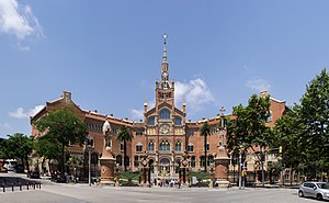
Hospital de Sant Pau
Former hospital complex in Barcelona, Spain
Distance: Approx. 1014 meters
Latitude and longitude: 41.41277778,2.17444444
The former Hospital de la Santa Creu i Sant Pau (Catalan pronunciation: [uspiˈtal də lə ˈsantə ˈkɾɛw i ˈsam ˈpaw], English: Hospital of the Holy Cross and Saint Paul) in the neighborhood of El Guinardó, Barcelona, Catalonia, Spain, is a complex built between 1901 and 1930. It is one of the most prominent works of the Catalan modernisme architect Lluís Domènech i Montaner. The complex was listed as a Conjunto Histórico in 1978.

Horta-Guinardó
Distance: Approx. 826 meters
Latitude and longitude: 41.41305556,2.16638889
Horta-Guinardó (Catalan pronunciation: [ˈɔɾtə ɣinəɾˈðo]) is the name of one of the districts of Barcelona, located in its North-Eastern corner. It is named after two very heterogeneous areas of the city, Horta and el Guinardó, which together cover a large area of 11.92 km2, amounting to 11.9% of the total area of the city. A former municipality that eventually became part of the city in the late 19th century, it is bordered by five out of ten districts of Barcelona (Gràcia, Nou Barris, Eixample, Sant Andreu and Sant Martí), and by two other municipalities of the metropolitan area (Sant Cugat and Cerdanyola del Vallès).

Alfons X (Barcelona Metro)
Metro station in Barcelona, Spain
Distance: Approx. 934 meters
Latitude and longitude: 41.41222222,2.16527778
Alfons X (Catalan pronunciation: [əlˈfonz ˈðɛw]) is a Barcelona metro station, located under Ronda Guinardó and Plaça d'Alfons el Savi, named after Alfonso X of Castile, in the Horta-Guinardó district of Barcelona. Opened in 1974 (1974), the station is currently served by L4. It has three entrances, one on the square itself, a second one next to Parc de les Aigües and another one on Carrer Lepant.

Horta (Barcelona Metro)
Metro station in Barcelona, Spain
Distance: Approx. 1119 meters
Latitude and longitude: 41.42944444,2.16194444
Horta (Catalan pronunciation: [ˈɔɾtə]) is a station in the Barcelona metro network, served by L5, located under carrer de Lisboa, in the Horta-Guinardó district of Barcelona. It was opened in 1967, when an extension of the line into the neighbourhood of the same name from Vilapicina was opened. The partially curved island-platform station has a ticket hall at either end, one with two accesses, the other with one.

Congrés (Barcelona Metro)
Metro station in Barcelona, Spain
Distance: Approx. 1114 meters
Latitude and longitude: 41.42333333,2.18055556
Congrés is a station on line 5 of the Barcelona Metro. The station is located underneath Carrer Garcilaso, between Carrer Matanzas and Carrer Francesc Tàrrega Claret. It was opened in 1959.

Maragall (Barcelona Metro)
Metro station in Barcelona, Spain
Distance: Approx. 941 meters
Latitude and longitude: 41.424,2.178
Maragall is a station serving line 4 and line 5 of the Barcelona Metro, of the capital of Catalonia, Spain. The line 5 station was opened in 1959 (1959) under Passeig Maragall, between Carrer Varsòvia and Carrer Mascaró. The curved central platform has a ticket hall at either end, the southern one giving access to the line 4 station.

Guinardó – Hospital de Sant Pau (Barcelona Metro)
Metro station in Barcelona, Spain
Distance: Approx. 732 meters
Latitude and longitude: 41.41604167,2.17436389
Guinardó | Hospital de Sant Pau (until 2009 Guinardó) is a station of the Barcelona Metro, on L4, serving Ronda del Guinardó and Plaça del Guinardó. It opened in 1974 (1974). The station is due to become part of double line L9-L10 in the near future.
Vilapicina i la Torre Llobeta
Distance: Approx. 965 meters
Latitude and longitude: 41.42876111,2.17087222
Vilapicina i Torre Llobeta is a neighborhood in the Nou Barris district of Barcelona, Catalonia (Spain).

Can Baró
Neighborhood in Barcelona, Spain
Distance: Approx. 631 meters
Latitude and longitude: 41.41785278,2.16104444
Can Baró is a neighborhood in the Horta-Guinardó district of Barcelona, Catalonia (Spain). It is home to the Turó de la Rovira Museum of the History of Barcelona (MUHBA) heritage site, where anti-aircraft batteries were stationed during the Spanish Civil War. This heritage location also became a popular destination for crowds to gather at night-time, largely due to the peaceful location and panoramic view of the city.
El Guinardó
Distance: Approx. 38 meters
Latitude and longitude: 41.42055556,2.16739444
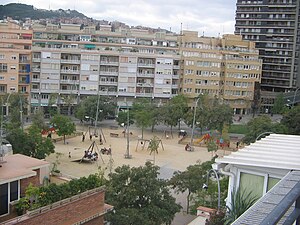
El Guinardó is a neighborhood in the Horta-Guinardó district of Barcelona (Spain).
La Font d'en Fargues
Distance: Approx. 537 meters
Latitude and longitude: 41.42491667,2.16552778
La Font d'en Fargues is a neighborhood in the Horta-Guinardó district of Barcelona, Catalonia (Spain).

Nou Sardenya
Distance: Approx. 1092 meters
Latitude and longitude: 41.4118,2.1615
Nou Sardenya is a municipally-owned football stadium in the Gràcia district of Barcelona, Catalonia, Spain. It is currently used mostly for football matches and is the home ground of CE Europa. The stadium holds about 7,000.
Weather in this IP's area
broken clouds
12 Celsius
12 Celsius
11 Celsius
14 Celsius
1023 hPa
73 %
1023 hPa
1001 hPa
10000 meters
2.06 m/s
320 degree
75 %
07:40:16
17:31:56
