Country:
Region:
City:
Latitude and Longitude:
Time Zone:
Postal Code:
IP information under different IP Channel
ip-api
Country
Region
City
ASN
Time Zone
ISP
Blacklist
Proxy
Latitude
Longitude
Postal
Route
Luminati
Country
Region
ct
ASN
Time Zone
Europe/Madrid
ISP
Adamo Telecom Iberia S.A.
Latitude
Longitude
Postal
IPinfo
Country
Region
City
ASN
Time Zone
ISP
Blacklist
Proxy
Latitude
Longitude
Postal
Route
db-ip
Country
Region
City
ASN
Time Zone
ISP
Blacklist
Proxy
Latitude
Longitude
Postal
Route
ipdata
Country
Region
City
ASN
Time Zone
ISP
Blacklist
Proxy
Latitude
Longitude
Postal
Route
Popular places and events near this IP address

Daimús
Municipality in Valencian Community, Spain
Distance: Approx. 2326 meters
Latitude and longitude: 38.96805556,-0.15444444
Daimús (Valencian: [dajˈmus]; Spanish: Daimuz [dajˈmuθ]) is a small municipality in the Safor comarca, in the Valencian Community close to the Mediterranean Sea in Spain. It has a population of about 2,200 inhabitants in winter and around 20,000 in summer.
Almoines
Municipality in Valencian Community, Spain
Distance: Approx. 3733 meters
Latitude and longitude: 38.94333333,-0.18222222
Almoines (Valencian: [alˈmɔjnes]; Spanish: [alˈmojnes]) is a municipality in the comarca of Safor in the Valencian Community, Spain.
L'Alqueria de la Comtessa
Municipality in Valencian Community, Spain
Distance: Approx. 2020 meters
Latitude and longitude: 38.93611111,-0.15444444
L'Alqueria de la Comtessa (Valencian: [lalkeˈɾi.a ðe la komˈtesa]; Spanish: Alquería de la Condesa [alkeˈɾi.a ðe la konˈdesa] is a municipality in the comarca of Safor in the Valencian Community, Spain. Traditionally based on agriculture, the cultivated area occupies most of the communal lands. In the dry part, there are olive trees and carob trees.

Bellreguard
Municipality in Valencian Community, Spain
Distance: Approx. 1993 meters
Latitude and longitude: 38.94638889,-0.1625
Bellreguard (Valencian: [ˌbeʎreˈɣwaɾt]; Spanish: Bellreguart [ˌbelreˈɣwaɾt]) is a municipality in the comarca of Safor in the Valencian Community, Spain. Bellreguard is a small village of just over 4,000 inhabitants located in the southeast of Valencia province, in the Mediterranean coast of Spain. The local festivals are celebrated in September and the Moros i Cristians (Moors and Christians) parade is the most notable.
Guardamar de la Safor
Municipality in Valencian Community, Spain
Distance: Approx. 1484 meters
Latitude and longitude: 38.96111111,-0.15027778
Guardamar de la Safor (Valencian pronunciation: [ˌɡwaɾðaˈmaɾ ðe la saˈfoɾ]) is a municipality in the comarca of Safor in the Valencian Community, Spain.

Miramar, Spain
Municipality in Valencian Community, Spain
Distance: Approx. 112 meters
Latitude and longitude: 38.95,-0.13888889
Miramar (Valencian pronunciation: [miɾaˈmaɾ]) is a municipality in the comarca of Safor in the Valencian Community, Spain.

Palmera
Municipality in Valencian Community, Spain
Distance: Approx. 1398 meters
Latitude and longitude: 38.94166667,-0.15166667
Palmera (Valencian pronunciation: [palˈmeɾa]) is a municipality in the comarca of Safor in the Valencian Community, Spain.

Piles, Spain
Municipality in Valencian Community, Spain
Distance: Approx. 1237 meters
Latitude and longitude: 38.94111111,-0.13222222
Piles (Valencian pronunciation: [ˈpiles]) is a municipality in the comarca of Safor in the Valencian Community, Spain. One of the watchtowers to defend Valencia against north-African forces was built in Piles 1577.

Rafelcofer
Distance: Approx. 2970 meters
Latitude and longitude: 38.9347,-0.1678
Rafelcofer (Valencian pronunciation: [raˌfɛlkoˈfeɾ]) is a village in the Valencian Community, Spain. Its mayor has been Maria del Carmen Llibrer Ballester since her election in June, 2007.
Archaeological Museum of Gandia
Distance: Approx. 3755 meters
Latitude and longitude: 38.96696,-0.17786
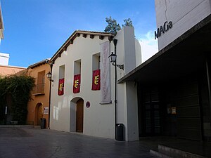
The Archaeological Museum of Gandia is a center where is shown the archaeological heritage of La Safor and Gandia area, but especially, the materials of the Parpalló cave. In 1972, with the collaboration of the Diputación de Valencia, was officially inaugurated the museum, now known by the acronym Maga, and is located in the old building of the Sant Marc Hospital, in the South-East end of the medieval walls of Gandia, on the left bank of the river Serpis. The museum was closed to the public during the period from 1987 to 2003.
Convent of Santa Clara of Gandia
Convent in Valencia, Spain
Distance: Approx. 3786 meters
Latitude and longitude: 38.96745556,-0.17791111
The Convent of Santa Clara is 15th-century, Roman Catholic convent belonging to cloistered order of the Colettine Poor Clares, and located in the town of Gandia, province of Valencia, Spain. It is located in the centre of Gandia and at few meters from the Collegiate Basilica of Gandia, in María Enríquez de Luna square.
Francis Borgia College, Gandia
School in Gandia, Valencia, Spain
Distance: Approx. 3808 meters
Latitude and longitude: 38.9653,-0.17966389
Francis Borgia College, Gandia (Spanish: Colegio Borja), is a private Catholic multilingual nursery through secondary school (ESO), located in Gandia, Valencia, Spain. The origins of the school date to 1543 and is run by the Society of Jesus.The school shares space with the Jesuit community and the Ducal Palace of Gandia.
Weather in this IP's area
overcast clouds
16 Celsius
16 Celsius
15 Celsius
18 Celsius
1021 hPa
86 %
1021 hPa
1019 hPa
10000 meters
8.05 m/s
11.18 m/s
49 degree
100 %
07:43:46
17:46:53

