91.126.122.95 - IP Lookup: Free IP Address Lookup, Postal Code Lookup, IP Location Lookup, IP ASN, Public IP
Country:
Region:
City:
Location:
Time Zone:
Postal Code:
ISP:
ASN:
language:
User-Agent:
Proxy IP:
Blacklist:
IP information under different IP Channel
ip-api
Country
Region
City
ASN
Time Zone
ISP
Blacklist
Proxy
Latitude
Longitude
Postal
Route
db-ip
Country
Region
City
ASN
Time Zone
ISP
Blacklist
Proxy
Latitude
Longitude
Postal
Route
IPinfo
Country
Region
City
ASN
Time Zone
ISP
Blacklist
Proxy
Latitude
Longitude
Postal
Route
IP2Location
91.126.122.95Country
Region
catalunya
City
manresa
Time Zone
Europe/Madrid
ISP
Language
User-Agent
Latitude
Longitude
Postal
ipdata
Country
Region
City
ASN
Time Zone
ISP
Blacklist
Proxy
Latitude
Longitude
Postal
Route
Popular places and events near this IP address
Manresa
Municipality in Catalonia, Spain
Distance: Approx. 476 meters
Latitude and longitude: 41.72944444,1.82722222
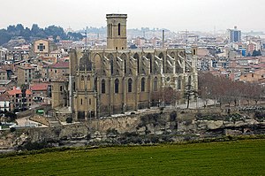
Manresa (Catalan pronunciation: [mənˈrɛzə]) is the capital of Bages county, located in the central region of Catalonia, Spain. Crossed by the river Cardener, it is an industrial area with textile, metallurgical, and glass industries. The houses of Manresa are arranged around the basilica of Santa Maria de la Seu.

Pavelló Nou Congost
Distance: Approx. 1426 meters
Latitude and longitude: 41.72533333,1.80933889
Pavelló Nou Congost is an arena in Manresa, Spain, with a capacity of 5,000 spectators. It is primarily used for basketball. It is the home arena of Bàsquet Manresa.
Castellgalí
Municipality in Catalonia, Spain
Distance: Approx. 5889 meters
Latitude and longitude: 41.673,1.838
Castellgalí (Catalan pronunciation: [kəsˌteʎ.ɣəˈli]) is a municipality in the south of the region of Bages, Catalonia, where the Cardener and Llobregat rivers meet, and contains the BCIN (Cultural Asset of National Interest) Boades archaeological site and the Torre del Breny, one of the most outstanding ancient Greek sites in Catalonia.

Sant Joan de Vilatorrada
Municipality in Catalonia, Spain
Distance: Approx. 3531 meters
Latitude and longitude: 41.75,1.8
Sant Joan de Vilatorrada (Catalan pronunciation: [ˈsaɲ ʒuˈan də ˌβilətuˈraðə]) is a municipality in the comarca of the Bages in Catalonia, Spain. It is about 50 kilometres (31 mi) away from Barcelona. The town of Sant Joan de Vilatorrada is located at 3 km.

Pla de Bages
Distance: Approx. 1214 meters
Latitude and longitude: 41.72055556,1.83972222
Pla de Bages is a Spanish Denominación de Origen Protegida (DOP) (Denominació d'Origen Protegida in Catalan) for Catalan wines, located in the province of Barcelona (Catalonia, Spain), and is one of the smallest DOPs in Spain, covering less than 500 hectares. It is also one of the newest having acquired its official status in 1997.
County of Manresa
Distance: Approx. 334 meters
Latitude and longitude: 41.7282,1.8263
The County of Manresa (Catalan: Comtat de Manresa, Spanish: Condado de Manresa) is the western extremity of the County of Osona, divided into the Moianès and Bages. Through the Reconquista, Manresa was extended as far as Anoia, Segarra, and Urgell. The castle at Manresa dates from the last quarter of the ninth century.
Sant Benet de Bages
Former Benedictine monastery in Catalonia, Spain
Distance: Approx. 6340 meters
Latitude and longitude: 41.743,1.899
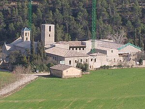
The Monastery of Sant Benet de Bages is a former Benedictine monastery, in the comarca of Bages, Catalonia, Spain. The Romanesque monastery was thoroughly restored at the beginning of the twentieth century by the Catalan architect Josep Puig i Cadafalch.
Santa Maria, Manresa
Distance: Approx. 371 meters
Latitude and longitude: 41.72189722,1.82708889
The Collegiate Basilica of Santa Maria (Catalan: Santa Maria de Manresa; Spanish: Santa María de Manresa), also known as La Seu, is a Romanesque-Gothic church in Manresa, Catalonia, north of Spain.

El Pont de Vilomara i Rocafort
Municipality in Catalonia, Spain
Distance: Approx. 4648 meters
Latitude and longitude: 41.702,1.873
El Pont de Vilomara i Rocafort (Catalan pronunciation: [əl ˈpɔn də βiluˈmaɾəj ˌrɔkəˈfɔɾt]) is a municipality in the province of Barcelona and autonomous community of Catalonia, Spain. It covers an area of 27.35 square kilometres (10.56 sq mi) and the population in 2014 was 3,780. The municipality comprises the settlements of El Pont de Vilomara (1998 population 2,111), Rocafort (55), and River Parc (36).

Museu Comarcal de Manresa
Distance: Approx. 335 meters
Latitude and longitude: 41.72473056,1.83048611
The Museu Comarcal de Manresa (Manresa Regional Museum) is a pluridisciplinary museum created on 2 September 1896 in Manresa and currently located in the old elementary school of Sant Ignasi (Saint Ignatius). It is part of the Barcelona Provincial Council Local Museum Network.

Battle of Manresa (1810)
1810 battle during the Peninsular War
Distance: Approx. 476 meters
Latitude and longitude: 41.72944444,1.82722222
The Battle of Manresa and Battle of Vilafranca from 21 March to 5 April 1810 saw a Spanish division led by Juan Caro and Luis González Torres de Navarra, Marquess of Campoverde attack an Imperial French brigade commanded by François Xavier de Schwarz.
Cave of Saint Ignatius
Church building in Manresa, Catalonia
Distance: Approx. 609 meters
Latitude and longitude: 41.7212,1.8315
The Cave of Saint Ignatius is a sanctuary declared as a Local Cultural Heritage that includes a baroque church and a neoclassical building in Manresa (Catalonia), which was created to honor the place where, according to tradition, Saint Ignatius of Loyola shut himself in a cave to pray and do penance during his sojourn in the city from March 1522 to February 1523, where he wrote the Spiritual Exercises returning from his pilgrimage to Montserrat.
Weather in this IP's area
overcast clouds
12 Celsius
10 Celsius
12 Celsius
12 Celsius
1025 hPa
34 %
1025 hPa
973 hPa
10000 meters
1.45 m/s
1.24 m/s
307 degree
99 %


