91.126.106.179 - IP Lookup: Free IP Address Lookup, Postal Code Lookup, IP Location Lookup, IP ASN, Public IP
Country:
Region:
City:
Location:
Time Zone:
Postal Code:
ISP:
ASN:
language:
User-Agent:
Proxy IP:
Blacklist:
IP information under different IP Channel
ip-api
Country
Region
City
ASN
Time Zone
ISP
Blacklist
Proxy
Latitude
Longitude
Postal
Route
db-ip
Country
Region
City
ASN
Time Zone
ISP
Blacklist
Proxy
Latitude
Longitude
Postal
Route
IPinfo
Country
Region
City
ASN
Time Zone
ISP
Blacklist
Proxy
Latitude
Longitude
Postal
Route
IP2Location
91.126.106.179Country
Region
cantabria
City
ramales de la victoria
Time Zone
Europe/Madrid
ISP
Language
User-Agent
Latitude
Longitude
Postal
ipdata
Country
Region
City
ASN
Time Zone
ISP
Blacklist
Proxy
Latitude
Longitude
Postal
Route
Popular places and events near this IP address

Lanestosa
Place in Biscay, Spain
Distance: Approx. 5199 meters
Latitude and longitude: 43.21527778,-3.43694444
Lanestosa is a town and municipality located in the province of Biscay, in the autonomous community of Basque Country, northern Spain. It is a little municipality in the very west of Basque Country.
Gibaja
Distance: Approx. 3890 meters
Latitude and longitude: 43.28333333,-3.43333333
Gibaja (pop. 385) is situated in the north of Spain, in the Autonomous Region of Cantabria. It belongs to the council of Ramales de la Victoria.

Asón-Agüera
Comarca in Cantabria, Spain
Distance: Approx. 3792 meters
Latitude and longitude: 43.2883,-3.4461
The Asón-Agüera comarca is a historical region of Cantabria, Spain. It is located in the upper courses of the Asón and Agüera rivers, near the border with Vizcaya in the Basque Country. The comarca encompasses the basin of the Asón river and its tributaries such as the Gándara.

Battle of Ramales
Battle of the First Carlist War
Distance: Approx. 118 meters
Latitude and longitude: 43.25631111,-3.46441667
The Battle of Ramales, a battle of the First Carlist War, occurred at Ramales in Cantabria on May 12, 1839. The successful Liberals were commanded by Baldomero Espartero, the Carlists by Rafael Maroto.

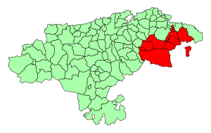
Ramales de la Victoria
Municipality in Cantabria, Spain
Distance: Approx. 216 meters
Latitude and longitude: 43.25888889,-3.46388889
Ramales de La Victoria is a municipality located in the autonomous community of Cantabria, Spain. The Battle of Ramales took place here in 1839 during the First Carlist War.
Cave del Valle (Cantabria)
Cave and archaeological site in Spain
Distance: Approx. 5916 meters
Latitude and longitude: 43.29861111,-3.41944444
Cave del Valle (Spanish: Cueva del Valle, The Valley's Cave), locally also known as La Viejarrona (Old Girl), is located near El Cerro Village in the municipality of Rasines in Cantabria, northern Spain. The cave is the source of the Silencio River, a tributary of the Rio Ruahermosa, which in turn is a tributary of the Asón River. Notable for its prehistoric, but particularly for its speleologic significance as it is recognized as one of the longest cavities in the world.

Ruesga
Place in Cantabria, Spain
Distance: Approx. 8184 meters
Latitude and longitude: 43.2825,-3.56
Ruesga (Spanish pronunciation: [ˈrwesɣa]) is a municipality in Cantabria Province, Spain. It includes the following 6 villages: Calseca, Matienzo, Mentera Barruelo, Ogarrio, Riva (capital) and Valle. As of 2016, a total of 870 people lived in Ruesga.

Rasines
Municipality in Cantabria, Spain
Distance: Approx. 6543 meters
Latitude and longitude: 43.30805556,-3.42472222
Rasines is a municipality located in the autonomous community of Cantabria, Spain.

El Mirón Cave
Cave and archaeological site in Spain
Distance: Approx. 1659 meters
Latitude and longitude: 43.24638889,-3.45111111
The El Mirón Cave is a large cave in the upper Asón River valley towards the eastern end of Cantabria in northern Spain, near the border of the Basque country. It is an archeological site in Ramales de la Victoria. It is known for a skeleton belonging to a woman nicknamed The Red Lady of El Mirón.

Torca del Carlista
Enormous cavern in Spain
Distance: Approx. 6253 meters
Latitude and longitude: 43.2635,-3.38855833
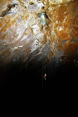
Torca del Carlista (English: Carlista Cavern) is a large limestone cavern found in Cantabria, Spain, approximately 35 kilometres (22 mi) from the city of Bilbao. The entrance, up the slopes of the Cantabrian Mountains, is only a single metre (3 feet) wide. The entry passage descends some 45 metres (148 ft) vertically in a narrow chimney before opening up into the cavern's main gallery.
Mortillano system
Karst system in Spain
Distance: Approx. 8827 meters
Latitude and longitude: 43.2307405,-3.5678092
The Mortillano system is the second longest karst system in Spain and one of the largest in Europe, the sixth, with 146.5 km of galleries. It is also the 15th longest cave system in the world.
Weather in this IP's area
clear sky
3 Celsius
3 Celsius
3 Celsius
3 Celsius
1034 hPa
71 %
1034 hPa
970 hPa
10000 meters
0.87 m/s
0.82 m/s
213 degree
2 %
