Country:
Region:
City:
Latitude and Longitude:
Time Zone:
Postal Code:
IP information under different IP Channel
ip-api
Country
Region
City
ASN
Time Zone
ISP
Blacklist
Proxy
Latitude
Longitude
Postal
Route
Luminati
Country
Region
br
City
brest
ASN
Time Zone
Europe/Minsk
ISP
MTK Global Ltd
Latitude
Longitude
Postal
IPinfo
Country
Region
City
ASN
Time Zone
ISP
Blacklist
Proxy
Latitude
Longitude
Postal
Route
db-ip
Country
Region
City
ASN
Time Zone
ISP
Blacklist
Proxy
Latitude
Longitude
Postal
Route
ipdata
Country
Region
City
ASN
Time Zone
ISP
Blacklist
Proxy
Latitude
Longitude
Postal
Route
Popular places and events near this IP address

Mukhavets
River in Belarus
Distance: Approx. 2530 meters
Latitude and longitude: 52.0835,23.6482
The Mukhavets (Belarusian: Мухавец, romanized: Mukhaviets [muxaˈvʲets]; Russian: Муховец, romanized: Mukhovets, Polish: Muchawiec) is a river in western Belarus. A tributary of the Bug River, the Mukhavets rises in Pruzhany, Belarus, where the Mukha river and the Vyets canal converge, flows through south-western Belarus and merges with the Bug River in Brest. The river is 113 km long with a 6,600 km2 (2,500 sq mi) basin area.

Brest Litovsk Voivodeship
Voivodeship of the Grand Duchy of Lithuania
Distance: Approx. 1742 meters
Latitude and longitude: 52.08663,23.658771
Brest Litovsk Voivodeship (Belarusian: Берасьцейскае ваяводзтва; Polish: Województwo brzeskolitewskie) was a unit of administrative territorial division and a seat of local government (voivode) within the Grand Duchy of Lithuania (Polish–Lithuanian Commonwealth) since 1566 until the May Constitution in 1791, and from 1791 to 1795 (partitions of Poland) as a voivodeship in Poland. It was constituted from Brest-Litovsk and Pinsk counties.

Brest Fortress
Fortress in Brest, Belarus
Distance: Approx. 1970 meters
Latitude and longitude: 52.082,23.658
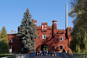
Brest Fortress (Belarusian: Брэсцкая крэпасць, romanized: Bresckaja krepasć; Polish: Twierdza brzeska; Lithuanian: Bresto tvirtovė; Russian: Брестская крепость), formerly known as Brest-Litovsk Fortress, is a 19th-century fortress in Brest, Belarus. In 1965, the title Hero Fortress was given to the fortress to commemorate the defence of the frontier stronghold during the first week of Operation Barbarossa, when Axis forces invaded the Soviet Union on 22 June 1941. The title "Hero Fortress" corresponds to the title "Hero City" that the Presidium of the Supreme Soviet of the Soviet Union awarded to twelve Soviet cities.

Brest City Park
Park in Brest, Belarus
Distance: Approx. 677 meters
Latitude and longitude: 52.09444444,23.67666667
Brest City Park is an urban public park in Brest, Belarus. The Russian soldiers of Libava Regiment, who were stationed in this part of Brest-Litovsk, laid out the park in 1906.

Brest District
District of Brest Region, Belarus
Distance: Approx. 3197 meters
Latitude and longitude: 52.11527778,23.66111111
Brest District (Belarusian: Брэсцкі раён; Russian: Брестский район) is an district (raion) of Brest Region in Belarus. Its administrative center is Brest, which is administratively separated from the district. As of 2024, it has a population of 45,658.

Regional Sport Complex Brestsky
Sports complex in Brest, Belarus
Distance: Approx. 37 meters
Latitude and longitude: 52.08982778,23.68391389
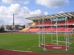
Regional Sport Complex Brestsky (Belarusian: Абласны спартыўны комплекс «Брэсцкi»; Russian: Областной спортивный комплекс «Брестский»), also known simply as OSK Brestsky or ASK Brestski is a multi-use stadium in Brest, Belarus. It is currently used mostly for football matches and is the home ground of FC Dinamo Brest. The stadium holds 10,060 people.

Brest Railway Museum
Museum in Brest, Belarus
Distance: Approx. 944 meters
Latitude and longitude: 52.08555556,23.67194444
The Brest Railway Museum or Brest Museum of Rail Equipment (Belarusian: Брэсцкі чыгуначны музей) is the first outdoor railway museum in Belarus, located in Brest, opened in 2002.

Brześć Ghetto
Nazi ghetto in occupied Belarus
Distance: Approx. 1572 meters
Latitude and longitude: 52.1,23.7
The Brześć Ghetto or the Ghetto in Brest on the Bug, also: Brześć nad Bugiem Ghetto, and Brest-Litovsk Ghetto (Polish: getto w Brześciu nad Bugiem, Yiddish: בריסק or בריסק-ד׳ליטע) was a Nazi ghetto created in occupied Western Belarus in December 1941, six months after the German troops had invaded the Soviet Union in June 1941. Less than a year after the creation of the ghetto, around October 15–18, 1942, most of approximately 20,000 Jewish inhabitants of Brest (Brześć) were murdered; over 5,000 were executed locally at the Brest Fortress on the orders of Karl Eberhard Schöngarth; the rest in the secluded forest of the Bronna Góra extermination site (the Bronna Mount, Belarusian: Бронная гара), sent there aboard Holocaust trains under the guise of 'resettlement'.

Millennium Monument of Brest
Monument in Brest, Belarus
Distance: Approx. 711 meters
Latitude and longitude: 52.0927,23.6931
Brest Millennium Monument (Belarusian: Помнік Тысячагоддзя Брэста) was designed by the Belarusian architect Alexei Andreyuk and sculptor Alexei Pavluchuk to commemorate the millennium of Brest, Belarus. It was erected in 2009 at the intersection of Sovietskaya Street and Gogol Street in Brest. The project was financed by the state budget and public donations.

Brest Castle (Belarus)
Distance: Approx. 2157 meters
Latitude and longitude: 52.0822,23.6548
Brest Castle (Belarusian: Берасцейскі замак) evolved in the course of several centuries from the Slavonic fortified settlement Berestye that had appeared at the turn of the 10th and 11th centuries at the confluence of the Mukhavets River into the Bug River, amid islands, formed by the rivers. It was re-built several times after numerous fires and sieges, was destroyed in the course of construction of the Brest Fortress in the 19th century.

Brest-Tsentralny railway station
Railway station in Belarus
Distance: Approx. 1176 meters
Latitude and longitude: 52.1005,23.6806
Brest-Tsentralny is the main railway station of Brest, Belarus.

Choral Synagogue (Brest)
Former synagogue in Brest, Belarus
Distance: Approx. 756 meters
Latitude and longitude: 52.0908,23.6946
The Choral Synagogue or the Great Synagogue is a former Orthodox Jewish synagogue tin Brest (known in Yiddish: Brisk), Belarus. Completed in c. 1862, it was used as a synagogue until World War II, and served as the main synagogue in Brest.
Weather in this IP's area
scattered clouds
4 Celsius
1 Celsius
4 Celsius
4 Celsius
1021 hPa
82 %
1021 hPa
1004 hPa
10000 meters
3.73 m/s
9.05 m/s
260 degree
39 %
08:46:00
17:34:03