Country:
Region:
City:
Latitude and Longitude:
Time Zone:
Postal Code:
IP information under different IP Channel
ip-api
Country
Region
City
ASN
Time Zone
ISP
Blacklist
Proxy
Latitude
Longitude
Postal
Route
Luminati
Country
City
kaiyiwan
ASN
Time Zone
Asia/Hong_Kong
ISP
Alice Networks Ltd
Latitude
Longitude
Postal
IPinfo
Country
Region
City
ASN
Time Zone
ISP
Blacklist
Proxy
Latitude
Longitude
Postal
Route
db-ip
Country
Region
City
ASN
Time Zone
ISP
Blacklist
Proxy
Latitude
Longitude
Postal
Route
ipdata
Country
Region
City
ASN
Time Zone
ISP
Blacklist
Proxy
Latitude
Longitude
Postal
Route
Popular places and events near this IP address

Tsuen Wan Government Secondary School
Government school in Tsuen Wan, Hong Kong
Distance: Approx. 301 meters
Latitude and longitude: 22.3726,114.1138
Tsuen Wan Government Secondary School (TWGSS; Chinese: 荃灣官立中學 or 荃官 in short) is an EMI co-education secondary school located at 70 Hoi Pa Street, Tsuen Wan, Hong Kong. The school building consists of the hall, the laboratory wing, the classroom wing, and the new wing (completed in 2003). Ms.

Tsuen Wan
Place in Hong Kong
Distance: Approx. 173 meters
Latitude and longitude: 22.36861111,114.11305556
Tsuen Wan (formerly also spelled Tsun Wan) is a town built on a bay in the western New Territories of Hong Kong, opposite of Tsing Yi Island across Rambler Channel. The market town of Tsuen Wan emerged from the surrounding villages and fleets of fishing boats in the area. The modern city is centered the Tsuen Wan station of the MTR. Its coastline was further extended through land reclamation.

Tsuen Wan Town Hall
Building in Tsuen Wan, Hong Kong
Distance: Approx. 163 meters
Latitude and longitude: 22.37083333,114.11277778
Tsuen Wan Town Hall is a town hall in Tsuen Wan, New Territories, Hong Kong. Originally it was intended to be located near Tsuen Wan station of the MTR, but it was re-located near the former Tsuen Wan Ferry Pier and Tsuen Wan Magistracy, between Tai Ho Road and Yuen Tun Circuit in late 1970s. The town hall was completed in 1980.
Sha Tsui
Distance: Approx. 256 meters
Latitude and longitude: 22.3676,114.114
Sha Tsui (Chinese: 沙咀/沙嘴) was a headland in Tsuen Wan, Hong Kong. It was situated at the west end of the old town of Tsuen Wan. The main road, Sha Tsui Road in the town centre of Tsuen Wan New Town is named after it.

Nina Tower
Skyscrapers in Tsuen Wan, Hong Kong
Distance: Approx. 173 meters
Latitude and longitude: 22.36861111,114.11305556
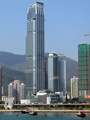
Nina Tower is a twin tower of 80-storey and 42-storey high-rise buildings in Tsuen Wan, New Territories, Hong Kong near Tsuen Wan West station. The tower was designed to be the tallest tower in the world at 518 m (1,699 ft). However, due to its location near Chek Lap Kok Airport, the height was restricted to the current 319.8 m (1,049 ft).
St. Francis Xavier's School, Tsuen Wan
Catholic boys secondary school in Tsuen Wan, Hong Kong
Distance: Approx. 336 meters
Latitude and longitude: 22.3687,114.117
St. Francis Xavier's School, Tsuen Wan (SFXS, TW; Chinese: 荃灣聖芳濟中學, 聖芳濟, 荃濟 or 濟記 in short) is located at 60 - 64 Ham Tin Street, Tsuen Wan, Hong Kong. The school is academically reputed and was founded in 1963.

Vision City (Hong Kong)
Building complex in Tsuen Wan, Hong Kong
Distance: Approx. 45 meters
Latitude and longitude: 22.3703,114.114
Vision City (Chinese: 萬景峯) is a residential high-rise development located in the Tsuen Wan district of the New Territories in Hong Kong. The complex consists of five towers, each of which ranks among the tallest buildings in the city. The tallest buildings in the complex are Vision City 2 and Vision City 3, which both rise 195 metres (640 ft) and 52 floors.

Citywalk, Hong Kong
Shopping mall
Distance: Approx. 11 meters
Latitude and longitude: 22.37,114.114
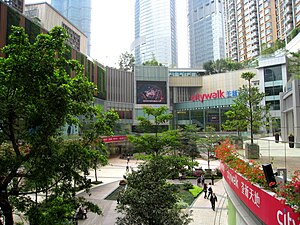
City Walk (Chinese: 荃新天地) is one of the largest shopping centres in Tsuen Wan, New Territories, Hong Kong. It is located at Yeung Uk Road, beneath Vision City (Chinese: 萬景峰) and opposite to Nina Tower, one of the tallest buildings in Hong Kong. It is jointly developed by Sino Land and Urban Renewal Authority.

Tsuen Wan Plaza
Building in Tsuen Wan, Hong Kong
Distance: Approx. 279 meters
Latitude and longitude: 22.37055556,114.11138889
Tsuen Wan Plaza (Chinese: 荃灣廣場) is a private housing estate and shopping mall in Tsuen Wan, New Territories, Hong Kong, located near the MTR Tsuen Wan West station, Tsuen Wan Ferry Pier, Nina Tower, Skyline Plaza, Citywalk and Citywalk 2. It is one of the largest shopping malls in the district. Built on the reclaimed land of the old Tsuen Wan Ferry Pier, it was developed by Sun Hung Kai Properties in 1992.
Skyline Plaza (Hong Kong)
Building in Tsuen Wan, Hong Kong
Distance: Approx. 241 meters
Latitude and longitude: 22.36972222,114.11166667
Skyline Plaza (Chinese: 灣景廣場) is a private housing estate and shopping mall in Tsuen Wan, Hong Kong. It is close to the Tsuen Wan Town Hall, Tsuen Wan Ferry Pier, Nina Tower and MTR Tsuen Wan West station. It was developed by the Henderson Land Development in April 1995.

Concord Square
Building in Tsuen Wan, Hong Kong
Distance: Approx. 145 meters
Latitude and longitude: 22.36979,114.1154
Concord Square (Chinese: 協和廣場) is a shopping centre in Tsuen Wan, New Territories, Hong Kong. Formerly the old buildings and villages in Tai Uk Wai (Chinese: 大屋圍), The Blue Yard (built in 2002) and the shopping centre were portions of Tsuen Wan Seven Street Redevelopment Project (Chinese: 荃灣七街重建計劃). It was completed in 2003 and developed by Concord Land Development Company Limited.

Tsuen Wan Transport Complex
Building in Tsuen Wan, Hong Kong
Distance: Approx. 282 meters
Latitude and longitude: 22.368918,114.111471
Tsuen Wan Transport Complex (Chinese: 荃灣運輸大樓) was a large transport hub in Tsuen Wan, Hong Kong. There was a bus terminus and taxi stand on the ground floor; on top sat a multi-storey car park.
Weather in this IP's area
overcast clouds
23 Celsius
24 Celsius
22 Celsius
25 Celsius
1018 hPa
72 %
1018 hPa
1016 hPa
10000 meters
5.81 m/s
30 degree
100 %
06:38:04
17:39:39

