90.84.153.128 - IP Lookup: Free IP Address Lookup, Postal Code Lookup, IP Location Lookup, IP ASN, Public IP
Country:
Region:
City:
Location:
Time Zone:
Postal Code:
IP information under different IP Channel
ip-api
Country
Region
City
ASN
Time Zone
ISP
Blacklist
Proxy
Latitude
Longitude
Postal
Route
Luminati
Country
ASN
Time Zone
Europe/Paris
ISP
ORANGE-CDN-AS
Latitude
Longitude
Postal
IPinfo
Country
Region
City
ASN
Time Zone
ISP
Blacklist
Proxy
Latitude
Longitude
Postal
Route
IP2Location
90.84.153.128Country
Region
provence-alpes-cote-d'azur
City
nice
Time Zone
Europe/Paris
ISP
Language
User-Agent
Latitude
Longitude
Postal
db-ip
Country
Region
City
ASN
Time Zone
ISP
Blacklist
Proxy
Latitude
Longitude
Postal
Route
ipdata
Country
Region
City
ASN
Time Zone
ISP
Blacklist
Proxy
Latitude
Longitude
Postal
Route
Popular places and events near this IP address

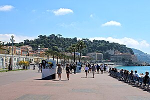
Nice
Prefecture in France
Distance: Approx. 37 meters
Latitude and longitude: 43.7034,7.2663
Nice (, NEESS; French pronunciation: [nis] ) is a city in and the prefecture of the Alpes-Maritimes department in France. The Nice agglomeration extends far beyond the administrative city limits, with a population of nearly one million on an area of 744 km2 (287 sq mi). Located on the French Riviera, the southeastern coast of France on the Mediterranean Sea, at the foot of the French Alps, Nice is the second-largest French city on the Mediterranean coast and second-largest city in the Provence-Alpes-Côte d'Azur region after Marseille.
Nice Carnival
Annual carnival in Nice, France
Distance: Approx. 37 meters
Latitude and longitude: 43.7034,7.2663
The Nice Carnival (French: Carnaval de Nice) is one of the world's major carnival events, alongside the Brazilian Carnival, Venetian Carnival, and Mardi Gras in New Orleans. It is held annually in February and sometimes early March (depending on the movable date of Carnival in the Christian calendar) in Nice on the French Riviera.

Arrondissement of Nice
Arrondissement in Provence-Alpes-Côte d'Azur, France
Distance: Approx. 348 meters
Latitude and longitude: 43.7,7.26666667
The arrondissement of Nice is an arrondissement of France in the Alpes-Maritimes department in the Provence-Alpes-Côte d'Azur region. It has 101 communes. Its population is 530,694 (2021), and its area is 3,067.4 km2 (1,184.3 sq mi).

Nice-Ville station
Railway station in Nice, France
Distance: Approx. 366 meters
Latitude and longitude: 43.70444444,7.26194444
Nice-Ville station (French: Gare de Nice-Ville), also known as Nice-Thiers station (Gare de Nice-Thiers), is the main railway station of Nice, France. It is situated on the Marseille–Ventimiglia railway and constitutes the southwestern terminus of the Nice–Breil-sur-Roya railway. Nice-Ville is served by TER, Intercités and TGV services, as well as the Gare Thiers stop on Line 1 of the Nice tramway.

County of Nice
Historical region now part of France
Distance: Approx. 466 meters
Latitude and longitude: 43.7,7.27
The County of Nice (French: Comté de Nice / Pays Niçois; Italian: Contea di Nizza / Paese Nizzardo; Niçard Occitan: Contèa de Niça / País Niçard) was a historical region of France located around the southeastern city of Nice and roughly equivalent to the modern arrondissement of Nice.

Siege of Nice
1543 siege
Distance: Approx. 348 meters
Latitude and longitude: 43.7,7.26667
The siege of Nice occurred in 1543 and was part of the Italian War of 1542–46 in which Francis I and Suleiman the Magnificent collaborated as part of the Franco-Ottoman alliance against the Holy Roman Emperor Charles V, and Henry VIII of England. At that time, Nice was under the control of Charles III, Duke of Savoy, an ally of Charles V. This is part of the 1543–1544 Mediterranean campaign of Barbarossa.

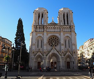
Notre-Dame de Nice
Church in Alpes-Maritimes, France
Distance: Approx. 24 meters
Latitude and longitude: 43.70331111,7.26606111
The Basilica of Notre-Dame de Nice (French: Basilique Notre-Dame de Nice) is a Roman Catholic basilica situated on the Avenue Jean Médecin in the centre of Nice, in France. It is built in the Neo-Gothic architectural tradition. The basilica, built between 1864 and 1868, was designed by Louis Lenormand and is the largest church in Nice, but is not the cathedral of the city.

Avenue Jean Médecin
Street in the center of Nice, France
Distance: Approx. 324 meters
Latitude and longitude: 43.70055556,7.26805556
The Avenue Jean Médecin is a street located in the center of Nice, one of the city's main north-south traffic arteries. In Niçard, it is officially named the "avenguda Jouan-Medecin, consòu de Nissa". It constitutes the city's main shopping street and is called "The Avenue" by residents.

Métropole Nice Côte d'Azur
Métropole in Provence-Alpes-Côte d'Azur, France
Distance: Approx. 466 meters
Latitude and longitude: 43.7,7.27
The Métropole Nice Côte d'Azur (French pronunciation: [metʁɔpɔl nis kot dazyʁ]) is the métropole, an intercommunal structure, centred on the city of Nice. It is located in the Alpes-Maritimes department, in the Provence-Alpes-Côte d'Azur region, Southeastern France. It was created on 31 December 2011, replacing the previous communauté urbaine of Nice Côte d'Azur and the communautés de communes of Les stations du Mercantour, La Tinée and Vésubie-Mercantour.

Palais Baréty
Distance: Approx. 555 meters
Latitude and longitude: 43.6984,7.2638
Palais Baréty is a historic building in Nice, Alpes-Maritimes, France. It was built in 1897 for Alexandre Baréty, a physician. It was designed by architect Lucien Barbet.
Nice Synagogue
Historic Orthodox synagogue located in Nice, France
Distance: Approx. 451 meters
Latitude and longitude: 43.6998,7.26935
The Nice Synagogue (French: Synagogue de Nice), also the Great Synagogue in Nice, is an Orthodox Jewish congregation and synagogue, located at 7, rue Gustave Deloye in Nice, Alpes-Maritimes, in the Provence-Alpes-Côte d'Azur region of France. Designed by Paul Martin, the synagogue was built in 1885, and dedicated in 1886. It was listed as a monument historique on April 17, 2004.

Canton of Nice-1
Canton in Provence-Alpes-Côte d'Azur, France
Distance: Approx. 600 meters
Latitude and longitude: 43.7,7.26
The canton of Nice-1 is an administrative division of the Alpes-Maritimes department, southeastern France. Its borders were modified at the French canton reorganisation which came into effect in March 2015. Its seat is in Nice.
Weather in this IP's area
clear sky
8 Celsius
5 Celsius
6 Celsius
12 Celsius
1030 hPa
31 %
1030 hPa
1027 hPa
10000 meters
5.66 m/s
330 degree

