Country:
 Netherlands
Region:
City:
Latitude and Longitude:
Time Zone:
Postal Code:
IP information under different IP Channel
ip-api
Country
Region
City
ASN
Time Zone
ISP
Blacklist
Proxy
Latitude
Longitude
Postal
Route
IPinfo
Country
Region
City
ASN
Time Zone
ISP
Blacklist
Proxy
Latitude
Longitude
Postal
Route
MaxMind
Country
Region
City
ASN
Time Zone
ISP
Blacklist
Proxy
Latitude
Longitude
Postal
Route
Luminati
Country
NLRegion
fl
City
lelystad
ASN
Time Zone
Europe/Amsterdam
ISP
Eurofiber Nederland BV
Latitude
Longitude
Postal
db-ip
Country
Region
City
ASN
Time Zone
ISP
Blacklist
Proxy
Latitude
Longitude
Postal
Route
ipdata
Country
Region
City
ASN
Time Zone
ISP
Blacklist
Proxy
Latitude
Longitude
Postal
Route
Popular places and events near this IP address

Lelystad
City and municipality in Flevoland, Netherlands
Distance: Approx. 2885 meters
Latitude and longitude: 52.5,5.48333333
Lelystad (Dutch pronunciation: [ˈleːlistɑt] ) is a Dutch municipality and the capital city of the province of Flevoland in the central Netherlands. The city, built on reclaimed land, was founded in 1967 and was named after Cornelis Lely, who engineered the Afsluitdijk that made the reclamation possible. Lelystad is situated approximately three metres (10 feet) below sea level.

Geography of the Netherlands
Distance: Approx. 3987 meters
Latitude and longitude: 52.5,5.5
The geography of the European Netherlands is unusual in that much of its land has been reclaimed from the sea and is below sea level, protected by dikes. It is a small country with a total area of 41,545 km2 (16,041 sq mi) and ranked 131st. With a population of 17.4 million and density of 521/km2 (1,350/sq mi) makes it the second most densely populated member of the European Union after Malta, and the 12th most densely populated country in the world, behind only three countries with a population over 16 million.
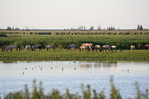
Oostvaardersplassen
Nature reserve in the Netherlands
Distance: Approx. 8128 meters
Latitude and longitude: 52.45,5.36666667
The Oostvaardersplassen (Dutch pronunciation: [oːstˈfaːrdərsˌplɑsə(n)]) is a nature reserve in the Netherlands, managed by the Staatsbosbeheer (state forestry service). Covering about 56 square kilometres (22 sq mi) in the province of Flevoland, it is an experiment in rewilding. It is in a polder created in 1968; by 1989, its ecological interest had resulted in its being declared a Ramsar wetland.
Lelystad Airport
Airport in Lelystad, Netherlands
Distance: Approx. 7741 meters
Latitude and longitude: 52.46027778,5.52722222
Lelystad Airport (IATA: LEY, ICAO: EHLE) is an airport 3.5 NM (6.5 km; 4.0 mi) south southeast of the city of Lelystad in Flevoland, Netherlands. It is the biggest general aviation airport in the Netherlands. The first flights were in 1971 and it became an official airport in 1973.

Aviodrome
Aerospace museum at Lelystad Airport in the Netherlands
Distance: Approx. 8082 meters
Latitude and longitude: 52.45722222,5.52944444
The Nationaal Luchtvaart-Themapark Aviodrome (also known simply as Aviodrome) is a large aerospace museum in the Netherlands that has been located on Lelystad Airport since 2003. Previously the museum was located at Schiphol Airport.

Flevopolder
Island polder in Flevoland, the Netherlands
Distance: Approx. 7429 meters
Latitude and longitude: 52.45,5.5
The Flevopolder is an island polder forming the bulk of Flevoland, a province of the Netherlands. Created by land reclamation, its northeastern part was drained in 1955 and the remainder—the southwest—in 1968. Unlike other major polders, it is surrounded by lakes and below-sea-level channels.

Lelystad Centrum railway station
Railway station in the Netherlands
Distance: Approx. 2113 meters
Latitude and longitude: 52.50777778,5.47333333
Lelystad Centrum is a railway station in the town of Lelystad, Netherlands. The station is on the Flevolijn and Hanzelijn and the train services are operated by Nederlandse Spoorwegen. The station was opened on 28 May 1988 after the extension from Almere Buiten was completed.

Lelystad Zuid railway station
Railway station in the Netherlands
Distance: Approx. 2861 meters
Latitude and longitude: 52.48638889,5.46805556
Lelystad Zuid is a railway station in the south of Lelystad, Flevoland, Netherlands. While constructed, the station is not planned to open before 2025. The station is located in a currently unbuilt area of Lelystad.
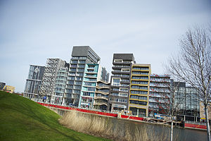
Zilverparkkade
Street in Lelystad, Netherlands
Distance: Approx. 2237 meters
Latitude and longitude: 52.50597,5.4752
Zilverparkkade is a street in Lelystad, Netherlands, containing a continuous row of wall-to-wall buildings constructed between 2002 and 2007. The name is used to refer to the group of buildings as a whole, as they were constructed together as an architectural project within the framework of renovation of the city center of Lelystad. The word kade means "quay" or "embankment", as the buildings face an artificial body of water within a small park called Zilverpark.
Nieuw Land National Park
National park in Flevoland, the Netherlands
Distance: Approx. 7029 meters
Latitude and longitude: 52.55,5.36666667
Nieuw Land National Park (New Land National Park; Dutch: Nationaal Park Nieuw Land) is a national park in the Dutch province of Flevoland. It was established on October 1, 2018, when Minister Carola Schouten visited the province to make the announcement. The national park is managed by the organizations Flevo-landschap, Staatsbosbeheer, and Natuurmonumenten.

Exposure (sculpture)
A steel frame sculpture of a crouching man
Distance: Approx. 2044 meters
Latitude and longitude: 52.52191667,5.42530556
Exposure (Exposure) is a steel frame sculpture on the Markerstrekdam near the Houtribsluizen in Lelystad Netherlands by artist Antony Gormley. The work is also known as Crouching man (Squatting man), or popularly called the Shitting Man.

H. Wortman Pumping Station
Building in Lelystad, Netherlands
Distance: Approx. 1540 meters
Latitude and longitude: 52.50305556,5.42027778
The H. Wortman Pumping Station (Dutch: Gemaal H. Wortman) is a pumping station in Lelystad, Flevoland, the Netherlands. Named for Hendrik Wortman, a civil engineer who contributed to the Zuiderzee Works, the station was designed by Dirk Roosenburg and completed in 1956. It was used for the reclamation of the eastern Flevopolder in 1957, and contributed to the reclamation of the polder's southern areas.
Weather in this IP's area
broken clouds
14 Celsius
14 Celsius
13 Celsius
16 Celsius
1029 hPa
93 %
1029 hPa
1030 hPa
10000 meters
2.24 m/s
4.47 m/s
68 degree
62 %
07:17:58
19:46:44