Country:
 Belgium
Region:
City:
Latitude and Longitude:
Time Zone:
Postal Code:
IP information under different IP Channel
ip-api
Country
Region
City
ASN
Time Zone
ISP
Blacklist
Proxy
Latitude
Longitude
Postal
Route
IPinfo
Country
Region
City
ASN
Time Zone
ISP
Blacklist
Proxy
Latitude
Longitude
Postal
Route
MaxMind
Country
Region
City
ASN
Time Zone
ISP
Blacklist
Proxy
Latitude
Longitude
Postal
Route
Luminati
Country
BERegion
wal
City
grezdoiceau
ASN
Time Zone
Europe/Brussels
ISP
Techit.be Srl
Latitude
Longitude
Postal
db-ip
Country
Region
City
ASN
Time Zone
ISP
Blacklist
Proxy
Latitude
Longitude
Postal
Route
ipdata
Country
Region
City
ASN
Time Zone
ISP
Blacklist
Proxy
Latitude
Longitude
Postal
Route
Popular places and events near this IP address

Chaumont-Gistoux
Municipality in French Community, Belgium
Distance: Approx. 6799 meters
Latitude and longitude: 50.67686,4.71956
Chaumont-Gistoux (French pronunciation: [ʃomɔ̃ ʒistu]; Walloon: Tchåmont-Djistou) is a municipality of Wallonia located in the Belgian province of Walloon Brabant. On 1 January 2006 Chaumont-Gistoux had a total population of 10,926. The total area is 48.09 km2 which gives a population density of 227 inhabitants per km2.

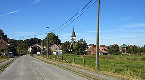
Grez-Doiceau
Municipality in French Community, Belgium
Distance: Approx. 486 meters
Latitude and longitude: 50.73333333,4.7
Grez-Doiceau (French: [ɡʁe dwaso]; Walloon: Gré; Dutch: Graven [ˈɣraːvə(n)]) is a municipality of Wallonia located in the Belgian province of Walloon Brabant. On January 1, 2006, Grez-Doiceau had a total population of 12,403. The total area is 55.44 km2 which gives a population density of 224 inhabitants per km2.

Pécrot rail crash
Distance: Approx. 6142 meters
Latitude and longitude: 50.78333333,4.65
The Pécrot rail crash was a rail accident in the village of Pécrot (part of the municipality of Grez-Doiceau), Belgium, that occurred on 27 March 2001 when two passenger trains collided head-on. The crash left 8 dead and 12 injured and was Belgium's worst rail disaster in a quarter of a century.
Beauvechain Air Base
Airport in Wallonia, Belgium
Distance: Approx. 5672 meters
Latitude and longitude: 50.75777778,4.76694444
Beauvechain Air Base (ICAO: EBBE) is a Belgian Air Component military airfield in Belgium, located 3 nautical miles (5.6 km; 3.5 mi) south of Beauvechain in Wallonia (Walloon Brabant Province); 20 mi (32 km) east-southeast of Brussels. It is home to the 1st Wing, operating A109BA helicopters, and the Basic Flying Training School, operating SIAI Marchetti SF.260 trainer aircraft. It is used as a base for the operational helicopter squadrons, and as a training center for pilots.
Bonlez Castle
Distance: Approx. 2984 meters
Latitude and longitude: 50.709,4.695
Bonlez Castle is a castle in Bonlez in the municipality of Chaumont-Gistoux, Walloon Brabant, Wallonia, Belgium.
Zeebroeck Castle
Distance: Approx. 5523 meters
Latitude and longitude: 50.78346111,4.67251667
Zeebroeck Castle is a castle in Nethen, Wallonia in the municipality of Grez-Doiceau, in the province of Walloon Brabant, Belgium.
Stade Justin Peeters
Distance: Approx. 5606 meters
Latitude and longitude: 50.72027778,4.61861111
The Stade Justin Peeters, (formerly the Justin Peeters Stadium) is a former football stadium located in Wavre near Brussels, Belgium and the former homeground of Racing Jet Wavre, that had come over the years to be found in the northeast of the city center under the significant address Avenue du Center Sportif. In 2021 the city converted it to a hockey field. From its dimensions, the stadium is more than roomy enough for a club that plays its home games before a nearly three-digit number of viewers, because it includes two lush stands on the sides, so that the lack of development behind the goals not go into further weight falls.
Sint-Agatha-Rode
Place in Flemish Region, Belgium
Distance: Approx. 6814 meters
Latitude and longitude: 50.78333333,4.63333333
Sint-Agatha-Rode, named after the third-century Christian martyr Saint Agatha of Sicily, is a Dutch-speaking village in Belgian province of Flemish Brabant and lies within the district of the town of Huldenberg. Historically Sint-Agatha-Rode was an independent municipality (Gemeente) until the merger of Belgian municipalities in 1977 when it was joined to the town of Huldenberg. Sint-Agatha-Rode is located east of the town centre of Huldenberg, in the hills between the valleys of the river Dijle which is the eastern boundary of the Huldenberg district and the river Laan which is the western boundary.

Ottenburg
Distance: Approx. 5879 meters
Latitude and longitude: 50.75277778,4.61527778
Ottenburg is a village in the municipality of Huldenberg in the province of Flemish Brabant, Belgium, close to the language border. The prehistoric earthwork, a long barrow known as de Tomme, is located here, identified in 2021 by archaeologists as the oldest such monument known in the Low Countries. During the period of French occupation (1795–1815), Ottenburg was known as Ottenbourg and was in the department of the Dyle.

Tourinnes-la-Grosse
Village in Brabant, Wallonia
Distance: Approx. 6587 meters
Latitude and longitude: 50.78333333,4.75
Tourinnes-la-Grosse (Dutch: Deurne; Walloon: (El Grosse) Tourene) is a village of Wallonia and a district of the municipality of Beauvechain, located in the province of Walloon Brabant, Belgium. It was a municipality in its own right before the fusion of the Belgian municipalities in 1977.
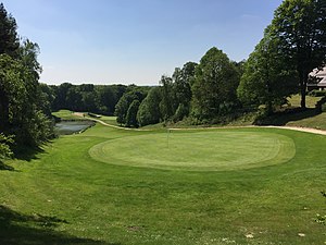
Royal Bercuit Golf Club
Golf Club in Belgium
Distance: Approx. 2332 meters
Latitude and longitude: 50.719444,4.673611
Royal Bercuit Golf Club is located in Grez-Doiceau, Wallonia, 30 km southeast of Brussels. The only course in Belgium designed by Robert Trent Jones, it has hosted events on both the European Tour and the Ladies European Tour.
Nodebais
Village in Brabant, Wallonia
Distance: Approx. 4957 meters
Latitude and longitude: 50.7725,4.73416667
Nodebais (Dutch: Nodebeek; Walloon: Nodebåy) is a village of Wallonia and a district of the municipality of Beauvechain, located in the province of Walloon Brabant, Belgium. It was a municipality in its own right before the fusion of the Belgian municipalities in 1977.
Weather in this IP's area
light rain
16 Celsius
16 Celsius
15 Celsius
17 Celsius
997 hPa
94 %
997 hPa
991 hPa
10000 meters
0.89 m/s
2.68 m/s
232 degree
100 %
07:52:58
19:04:06