89.47.253.228 - IP Lookup: Free IP Address Lookup, Postal Code Lookup, IP Location Lookup, IP ASN, Public IP
Country:
Region:
City:
Location:
Time Zone:
Postal Code:
ISP:
ASN:
language:
User-Agent:
Proxy IP:
Blacklist:
IP information under different IP Channel
ip-api
Country
Region
City
ASN
Time Zone
ISP
Blacklist
Proxy
Latitude
Longitude
Postal
Route
db-ip
Country
Region
City
ASN
Time Zone
ISP
Blacklist
Proxy
Latitude
Longitude
Postal
Route
IPinfo
Country
Region
City
ASN
Time Zone
ISP
Blacklist
Proxy
Latitude
Longitude
Postal
Route
IP2Location
89.47.253.228Country
Region
isle of man
City
douglas
Time Zone
Europe/Isle_of_Man
ISP
Language
User-Agent
Latitude
Longitude
Postal
ipdata
Country
Region
City
ASN
Time Zone
ISP
Blacklist
Proxy
Latitude
Longitude
Postal
Route
Popular places and events near this IP address

Tynwald
Legislature of the Isle of Man
Distance: Approx. 153 meters
Latitude and longitude: 54.1508,-4.4814
Tynwald (Manx: Tinvaal), or more formally, the High Court of Tynwald (Manx: Ard-whaiyl Tinvaal) or Tynwald Court, is the legislature of the Isle of Man. It consists of two chambers, known as the branches of Tynwald: the directly elected House of Keys and the indirectly chosen Legislative Council. When the two chambers sit together, they become "Tynwald Court".
House of Keys
Lower house of the Isle of Man parliament
Distance: Approx. 116 meters
Latitude and longitude: 54.15083333,-4.48222222
The House of Keys (Manx: Yn Kiare as Feed) is the directly elected lower house of Tynwald, the parliament of the Isle of Man, the other branch being the Legislative Council.

Legislative Council of the Isle of Man
Upper house of the parliament of the Isle of Man
Distance: Approx. 116 meters
Latitude and longitude: 54.15083333,-4.48222222
The Legislative Council (Manx: Yn Choonceil Slattyssagh) is the upper chamber of Tynwald, the legislature of the Isle of Man. The abbreviation "LegCo" is often used. It consists of eleven members (MLCs): Eight members elected by the House of Keys Three ex officio members: President of Tynwald, ex officio President of the Legislative Council (casting vote) Bishop of Sodor and Man Attorney General for the Isle of Man (non-voting) Historically, most or all elected MLCs were former MHKs, but this practice has now much reduced or ceased.
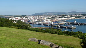
Douglas, Isle of Man
Capital city of the Isle of Man
Distance: Approx. 378 meters
Latitude and longitude: 54.15,-4.4775
Douglas (Manx: Doolish, pronounced [ˈdðuːlʲəʃ]) is the capital city and largest settlement of the Isle of Man, with a population of 26,677 (2021) and an area of 4.1 square miles (10.5 km2). It is located at the mouth of the River Douglas, and on a sweeping bay of two miles (three kilometres). The River Douglas forms part of the city's harbour and main commercial port.
Isle of Man Government
Government of the Isle of Man
Distance: Approx. 289 meters
Latitude and longitude: 54.15183333,-4.48016667
The Isle of Man Government (Manx: Reiltys Ellan Vannin) is the government of the Isle of Man. The formal head of the Isle of Man Government is the Lieutenant Governor, the personal representative of the Lord of Mann (currently Charles III). The executive head is the Chief Minister.
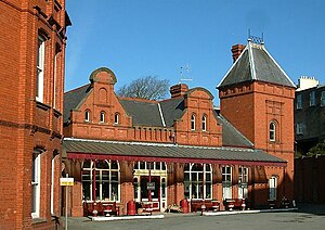
Douglas Railway Station
Railway station in Isle of Man, UK
Distance: Approx. 308 meters
Latitude and longitude: 54.14777778,-4.48611111
Douglas Railway Station (Manx: Stashoon Raad Yiarn Ghoolish) is the main terminus of the Isle of Man Railway and is located at the landward end of the quay in Douglas, the capital of the Isle of Man. It was once the hub for now closed lines to Peel, Ramsey and Foxdale.
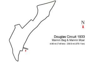
Mannin Moar
Distance: Approx. 527 meters
Latitude and longitude: 54.15400278,-4.47898889
The Mannin Moar was a non-championship Grand Prix held in Douglas, Isle of Man, Great Britain in 1933, 1934 and 1935. The most successful driver was Brian Lewis, having won all three races.

Douglas Circuit
Motor racing street circuit in Douglas
Distance: Approx. 527 meters
Latitude and longitude: 54.15400278,-4.47898889
The Douglas Circuit was a motor racing street circuit in Douglas, the capital and largest town of the Isle of Man and was re-configured each year until 1937. The first Grand Prix, titled "Mannin Beg & Mannin Moar" (English: Small Man & Big Man) was held in 1933 on a 4.60 mi (7.40 km) street circuit which repeated as II and III Mannin Moar on different circuit layouts until 1935. In 1936 the circuit changed again for the IV RAC International Light Car Race and a last time for the (1937) V RAC International Light Car Race.

Manx Museum
National Museum in Douglas, Isle of Man
Distance: Approx. 504 meters
Latitude and longitude: 54.15445,-4.48187
The Manx Museum (Manx: Thie Tashtee Vannin) in Douglas, Isle of Man is the national museum of the Isle of Man. It is run by Manx National Heritage. The museum covers 10,000 years the history of the Isle of Man from the Stone Age to the modern era.

HMS Valkyrie (shore establishment)
Distance: Approx. 426 meters
Latitude and longitude: 54.151,-4.477
HMS Valkyrie was a shore establishment or "stone frigate" of the Royal Navy located in Douglas, Isle of Man.

St George's Church, Isle of Man
Church in Isle of Man., Isle of Man
Distance: Approx. 74 meters
Latitude and longitude: 54.149384,-4.48371
St George's Church is an Anglican church in Douglas, Isle of Man and falls within the Diocese of Sodor and Man. It was formerly one of two worship centres in association with All Saints Church, Douglas.
Statue of Bee Gees (Douglas, Isle of Man)
2021 statue in Douglas, Isle of Man
Distance: Approx. 406 meters
Latitude and longitude: 54.15027778,-4.47708333
A statue of the Bee Gees by sculptor Andy Edwards was unveiled in Douglas, Isle of Man, in 2021. It is located on Loch Promenade between Marine Gardens 1 and 2 and opposite Regent Street. The 7-foot (2.1 m) bronze sculptures depict Barry, Maurice, and Robin Gibb, and the artist was inspired by the group's music video for "Stayin' Alive".
Weather in this IP's area
overcast clouds
10 Celsius
7 Celsius
10 Celsius
10 Celsius
1031 hPa
93 %
1031 hPa
1021 hPa
10000 meters
7.72 m/s
210 degree
100 %