Country:
Region:
City:
Latitude and Longitude:
Time Zone:
Postal Code:
IP information under different IP Channel
ip-api
Country
Region
City
ASN
Time Zone
ISP
Blacklist
Proxy
Latitude
Longitude
Postal
Route
Luminati
Country
Region
32
ASN
Time Zone
Europe/Rome
ISP
myNet GmbH
Latitude
Longitude
Postal
IPinfo
Country
Region
City
ASN
Time Zone
ISP
Blacklist
Proxy
Latitude
Longitude
Postal
Route
db-ip
Country
Region
City
ASN
Time Zone
ISP
Blacklist
Proxy
Latitude
Longitude
Postal
Route
ipdata
Country
Region
City
ASN
Time Zone
ISP
Blacklist
Proxy
Latitude
Longitude
Postal
Route
Popular places and events near this IP address

Kaltern an der Weinstraße
Comune in Trentino-Alto Adige/Südtirol, Italy
Distance: Approx. 475 meters
Latitude and longitude: 46.41666667,11.25
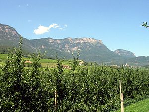
Kaltern an der Weinstraße (Austrian German: [ˈkaltɐn an deːɐ̯ ˈvaɪnˌʃtraːsɛ]; Italian: Caldaro sulla Strada del Vino [kalˈdaːro sulla ˈstraːda del ˈviːno]), often abbreviated to Kaltern or Caldaro, is a municipality and a village in South Tyrol in northern Italy. It is about 12 kilometres (7 mi) southwest of the city of Bolzano.
Vadena
Comune in Trentino-Alto Adige/Südtirol, Italy
Distance: Approx. 4146 meters
Latitude and longitude: 46.41666667,11.3
Vadena (Italian pronunciation: [ˈvaːdena]; German: Pfatten [ˈpfatn̩]) is a comune (municipality) in South Tyrol in northern Italy, located about 10 kilometres (6 mi) southwest of the city of Bolzano. It is one of only five mainly Italian speaking municipalities in South Tyrol.

Ruffré-Mendola
Comune in Trentino-Alto Adige/Südtirol, Italy
Distance: Approx. 4839 meters
Latitude and longitude: 46.41666667,11.18333333
Ruffré-Mendola (Rufré-Méndola in local dialect) is a comune (municipality) in Trentino in the northern Italian region Trentino-Alto Adige/Südtirol, located about 40 kilometres (25 mi) north of Trento. As of 31 December 2004, it had a population of 444 and an area of 6.6 square kilometres (2.5 sq mi). It borders the following municipalities: Sarnonico, Caldaro and Cavareno.

Überetsch-Unterland
District in Italy
Distance: Approx. 4387 meters
Latitude and longitude: 46.4,11.3
Überetsch-Unterland (Italian: Oltradige-Bassa Atesina [olˈtraːdidʒe bass ateˈziːna]; German: Überetsch-Unterland) is a district (Italian: comprensorio; German: Bezirksgemeinschaft) in the southern part of the Italian province of South Tyrol. It comprises the valley of the Adige river from Bolzano in the north to Salorno in the south.

Mendel Pass
Distance: Approx. 3019 meters
Latitude and longitude: 46.41694444,11.20722222
The Mendel Pass (German: Mendelpass or Mendel, Italian: Passo della Mendola, Passo Mendola or Mendola [ˈmendola]) is a 1,362 metre-high mountain pass in the Nonsberg Group of the Southern Rhaetian Alps between the provinces of Trentino and South Tyrol in Italy.

Überetsch Railway
Distance: Approx. 625 meters
Latitude and longitude: 46.41777778,11.25111111
The Überetsch Railway (German: Überetscher Bahn; Italian: Transatesina) connected Bolzano with the Mendel Funicular. This line was part of a rail sightseeing tour around the Mendelpass. The tour was made up of five railway lines and was often used by tourists.
Mendel funicular
Distance: Approx. 2059 meters
Latitude and longitude: 46.4125,11.2194
The Mendel Funicular, (German: Mendelbahn, Italian: Funicolare della Mendola [funikoˈlaːre della ˈmendola]) is a funicular railway in Italy. It connects the Überetsch plateau with the Mendel Pass.

Penegal
Mountain in Italy
Distance: Approx. 3608 meters
Latitude and longitude: 46.43854167,11.21670278
The Penegal is a mountain of the Nonsberg group near Kaltern, South Tyrol, Italy.

Kalterer See
Distance: Approx. 4177 meters
Latitude and longitude: 46.3775,11.2625
Lake Kaltern (Italian: Lago di Caldaro; German: Kalterer See) is a lake in the municipality of Kaltern in South Tyrol, Italy.

Montiggler Seen
Distance: Approx. 3532 meters
Latitude and longitude: 46.42305556,11.29
The Montiggler Seen are two lakes in the municipality of Eppan in South Tyrol, Italy.

Kaltern Friary
Building in South Tyrol, Italy
Distance: Approx. 187 meters
Latitude and longitude: 46.41277778,11.24388889
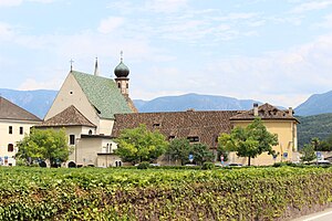
Kaltern Friary is a Franciscan friary in Kaltern (sometimes called Kaltern an der Weinstraße), South Tyrol, Italy. It is located in the centre of the little town and dates back to the 17th century.

Ansitz Kreit
Ansitz in South Tyrol
Distance: Approx. 3459 meters
Latitude and longitude: 46.44124389,11.26590306
Ansitz Kreit is an Ansitz in Eppan an der Weinstraße, South Tyrol, Italy.
Weather in this IP's area
overcast clouds
7 Celsius
7 Celsius
7 Celsius
7 Celsius
1015 hPa
77 %
1015 hPa
965 hPa
10000 meters
0.65 m/s
0.77 m/s
352 degree
98 %
07:21:22
16:39:26