Country:
Region:
City:
Latitude and Longitude:
Time Zone:
Postal Code:
IP information under different IP Channel
ip-api
Country
Region
City
ASN
Time Zone
ISP
Blacklist
Proxy
Latitude
Longitude
Postal
Route
Luminati
Country
ASN
Time Zone
Europe/Bucharest
ISP
iNES GROUP SRL
Latitude
Longitude
Postal
IPinfo
Country
Region
City
ASN
Time Zone
ISP
Blacklist
Proxy
Latitude
Longitude
Postal
Route
db-ip
Country
Region
City
ASN
Time Zone
ISP
Blacklist
Proxy
Latitude
Longitude
Postal
Route
ipdata
Country
Region
City
ASN
Time Zone
ISP
Blacklist
Proxy
Latitude
Longitude
Postal
Route
Popular places and events near this IP address

Stockholm
Capital and most populous city of the Kingdom of Sweden
Distance: Approx. 16 meters
Latitude and longitude: 59.32944444,18.06861111
Stockholm (Swedish: [ˈstɔ̂kː(h)ɔlm] ) is the capital and most populous city of the Kingdom of Sweden, as well as the largest urban area in the Nordic countries. Approximately 1 million people live in the municipality, with 1.6 million in the urban area, and 2.4 million in the metropolitan area. The city stretches across fourteen islands where Lake Mälaren flows into the Baltic Sea.
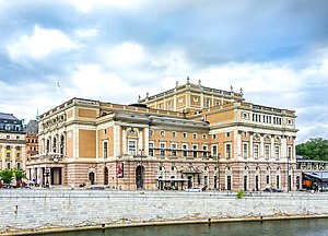
Royal Swedish Opera
Opera company in Stockholm, Sweden
Distance: Approx. 121 meters
Latitude and longitude: 59.32972222,18.07055556
Royal Swedish Opera (Swedish: Kungliga Operan) is an opera and ballet company based in Stockholm, Sweden.
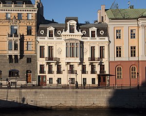
Sager House
Building in Stockholm, Sweden
Distance: Approx. 91 meters
Latitude and longitude: 59.32888889,18.06722222
The Sager House (Swedish: Sagerska huset) or Sager Palace (Sagerska palatset) is the official residence of the Prime Minister of Sweden, located at Strömgatan 18 in central Stockholm.

Battle of Brunkeberg
1471 battle of the Dano-Swedish War
Distance: Approx. 16 meters
Latitude and longitude: 59.32944444,18.06861111
The Battle of Brunkeberg was fought on 10 October 1471 between the Swedish regent Sten Sture the Elder and forces led by Danish king Christian I. Sture won a decisive victory.
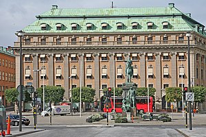
Gustav Adolfs torg, Stockholm
Distance: Approx. 48 meters
Latitude and longitude: 59.329,18.068
Gustav Adolfs torg is a public square in central Stockholm, Sweden.

Arvfurstens palats
Distance: Approx. 49 meters
Latitude and longitude: 59.32916667,18.06777778
Arvfurstens palats (Palace of the Hereditary Prince) is a palace located at Gustav Adolfs Torg in central Stockholm. Designed by Erik Palmstedt, the palace was originally the private residence of Princess Sophia Albertina. It was built 1783–1794 and declared a historical monument (byggnadsminne) in 1935 and subsequently restored by Ivar Tengbom in 1948–52.
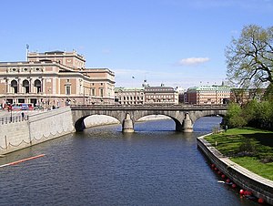
Norrbro
Distance: Approx. 133 meters
Latitude and longitude: 59.32830556,18.06988889
Norrbro (Swedish for "North Bridge") is an arch bridge over Norrström in central Stockholm. It extends north from the northern front of the Royal Palace passing over Helgeandsholmen in front of the Riksdag building, and from there over to Gustav Adolfs torg. Norrbro was designed by the city architect Erik Palmstedt (1741–1803) in a neoclassical style.
Ministry of Defence (Sweden)
Swedish government ministry responsible for national security policy
Distance: Approx. 105 meters
Latitude and longitude: 59.33022222,18.06817222
The Ministry of Defence (Swedish: Försvarsdepartementet) is a ministry in the Government of Sweden responsible for policies related to national defence and civil defence. The ministry is currently headed by the Minister for Defence, Pål Jonson of the Moderate Party.

Ministry of the Environment (Sweden)
Distance: Approx. 121 meters
Latitude and longitude: 59.33008333,18.06711111
The Ministry of the Environment (Swedish: Miljödepartementet), was a ministry within the Government of Sweden. It operated between 1987 and 2022. The ministry was merged into the Ministry of Enterprise and Innovation, forming the Ministry of Climate and Enterprise on 1 January 2023.

Saint James's Church, Stockholm
Church in Stockholm, Sweden
Distance: Approx. 111 meters
Latitude and longitude: 59.33,18.07
Saint James's Church (Swedish: Sankt Jacobs kyrka) is a church in central Stockholm, Sweden, dedicated to apostle Saint James the Greater, patron saint of travellers. It is often mistakenly called St Jacob's. The confusion arises because Swedish, like many other languages, uses the same name for both James and Jacob.

Jakobsgatan
Distance: Approx. 136 meters
Latitude and longitude: 59.33038889,18.06969444
Jakobsgatan is a street at Norrmalm in central Stockholm, Sweden. The street stretches from west-east Tegelbacken in the west to Västra Trädgårdsgatan in the east. At Jakobsgatan several entertainment places can be found such as Hamburger Börs and Centralpalatset.

Siege of Stockholm (1520)
Part of the Dano-Swedish War
Distance: Approx. 16 meters
Latitude and longitude: 59.32944444,18.06861111
The siege of Stockholm (1520) was a combined naval and army siege of the Swedish capital Stockholm by the Danish king Christian II during the Dano-Swedish War (1512-1520).
Weather in this IP's area
light snow
1 Celsius
-5 Celsius
1 Celsius
2 Celsius
985 hPa
87 %
985 hPa
982 hPa
7000 meters
6.69 m/s
350 degree
75 %
07:54:15
15:12:55
