Country:
 Romania
Region:
City:
Latitude and Longitude:
Time Zone:
Postal Code:
IP information under different IP Channel
ip-api
Country
Region
City
ASN
Time Zone
ISP
Blacklist
Proxy
Latitude
Longitude
Postal
Route
IPinfo
Country
Region
City
ASN
Time Zone
ISP
Blacklist
Proxy
Latitude
Longitude
Postal
Route
MaxMind
Country
Region
City
ASN
Time Zone
ISP
Blacklist
Proxy
Latitude
Longitude
Postal
Route
Luminati
Country
RORegion
is
City
luncacetatuii
ASN
Time Zone
Europe/Bucharest
ISP
Internet Broker Srl
Latitude
Longitude
Postal
db-ip
Country
Region
City
ASN
Time Zone
ISP
Blacklist
Proxy
Latitude
Longitude
Postal
Route
ipdata
Country
Region
City
ASN
Time Zone
ISP
Blacklist
Proxy
Latitude
Longitude
Postal
Route
Popular places and events near this IP address

Ciurea
Commune in Iași, Romania
Distance: Approx. 3973 meters
Latitude and longitude: 47.06666667,27.58333333
Ciurea is a commune in Iași County, Western Moldavia, Romania, part of the Iași metropolitan area. Situated 7 km south from the county seat of Iași, it is composed of seven villages: Ciurea, Curături, Dumbrava, Hlincea, Lunca Cetățuii, Picioru Lupului and Slobozia. It also includes the majority-Romani neighborhood of Zanea.
Valea Locii
River in Iași County, Romania
Distance: Approx. 669 meters
Latitude and longitude: 47.0935,27.5598
The Valea Locii (also: Valea Locei) is a left tributary of the river Nicolina in Romania. It flows into the Nicolina in Lunca Cetățuii. Its length is 12 km (7.5 mi) and its basin size is 85 km2 (33 sq mi).

Bârnova
Commune in Iași, Romania
Distance: Approx. 5869 meters
Latitude and longitude: 47.15,27.58333333
Bârnova is a commune in Iași County, Western Moldavia, Romania, part of the Iași Metropolitan Area. It is composed of six villages: Bârnova, Cercu, Păun, Pietrăria, Todirel and Vișan.

Socola Monastery
Distance: Approx. 5098 meters
Latitude and longitude: 47.1288566,27.6135007
Socola Monastery or Schimbarea la Față ("Transfiguration") was a Romanian Orthodox establishment located in the eponymous quarter of southern Iaşi, Romania. Founded during Moldavia's existence as a state, it was erected and dedicated by Moldavian Prince Alexandru Lăpuşneanu in 1562, and originally functioned as nunnery. The establishment acquired a significant historical position in Romanian education during the early 19th century, when it functioned as a seminary and the first-ever institution to provide secondary training in the Romanian language.

Bârnova Monastery
Distance: Approx. 5679 meters
Latitude and longitude: 47.074492,27.6275714
The Bârnova Monastery (Romanian: Mănăstirea Bârnova) is a Romanian Orthodox monastery located in Bârnova, Iași metropolitan area, Moldavia, Romania. Built in 1628 by Moldavian Voivode Miron Barnovschi-Movilă, the monastery is listed in the National Register of Historic Monuments. The oldest tree in Iași County is the 675-year-old hybrid lime tree (declared Natural Monument), located in the courtyard of Bârnova Monastery.

Galata Monastery
Distance: Approx. 5267 meters
Latitude and longitude: 47.14638889,27.56888889
The Galata Monastery (Romanian: Mănăstirea Galata) is a Romanian Orthodox monastery for nuns, founded at the end of the sixteenth century by Moldavian Voivode Petru Șchiopul, in the west of Iași, Romania. The monastery is located on the top of Galata Hill and can be easily observed from different locations of Iași. The church, surrounded by walls with loopholes and provided with a bell tower at the entrance, looks like a fortress, often serving as a place of defense and sometimes as a royal residence.
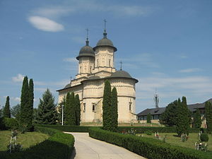
Cetățuia Monastery
Distance: Approx. 3946 meters
Latitude and longitude: 47.1314776,27.5839647
The Cetățuia Monastery (Romanian: Mănăstirea Cetățuia) is a Romanian Orthodox monastery located in Iași, Romania. The monastery is listed in the National Register of Historic Monuments.

Frumoasa Monastery
Distance: Approx. 4829 meters
Latitude and longitude: 47.13916667,27.58722222
The Frumoasa Monastery (Romanian: Mănăstirea Frumoasa) is a Romanian Orthodox monastery located in Iași, Romania. Built between 1726 and 1733, by Moldavian Prince Grigore II Ghica, the monastery is listed in the National Register of Historic Monuments.

Bucium Monastery
Church in Iași, Romania
Distance: Approx. 6053 meters
Latitude and longitude: 47.1138967,27.6390591
The Bucium Monastery (Romanian: Mănăstirea Bucium), dedicated to "The Sunday of all Aton Saints", is a Romanian Orthodox monastery, located at 14 Păun Street, in the Bucium Hill neighborhood of Iași, Romania.

Hlincea Monastery
Distance: Approx. 2033 meters
Latitude and longitude: 47.1114239,27.5821584
The Hlincea Monastery (Romanian: Mănăstirea Hlincea) is a Romanian Orthodox monastery in Ciurea, Iaşi metropolitan area, Romania. Located at the base of Cetăţuia Hill, the monastery was built by Maria, the daughter of Moldavian Prince Petru Şchiopul and dedicated in 1574. At the middle of the next century, it was rebuilt by Prince Vasile Lupu and finished by his son Ştefăniţă, in November 1660.
Socola Mică Church
Orthodox church in Iași, Romania
Distance: Approx. 4974 meters
Latitude and longitude: 47.1252,27.6156
The Socola Mică Church (Romanian: Biserica Socola Mică) is a Romanian Orthodox church located at 9 Socola Lane in Iași, Romania. It is dedicated to the Nativity of Mary, Athanasius of Alexandria and Cyril of Alexandria. After the seminary at Socola Monastery opened and the church became a students' chapel, local residents decided to build a new church.
Eugen Grigore case
Revenge attack in Romania on July 1974
Distance: Approx. 3973 meters
Latitude and longitude: 47.06666667,27.58333333
In July 1974, Romanian truck driver Eugen Grigore drove his cargo truck into a group of tents belonging to Romani nomads, killing 24 people and injuring 50 others. Grigore served c. 27 years in prison.
Weather in this IP's area
clear sky
14 Celsius
13 Celsius
11 Celsius
14 Celsius
1021 hPa
75 %
1021 hPa
1014 hPa
10000 meters
1.44 m/s
1.61 m/s
343 degree
06:38:34
19:36:31