Country:
Region:
City:
Latitude and Longitude:
Time Zone:
Postal Code:
IP information under different IP Channel
ip-api
Country
Region
City
ASN
Time Zone
ISP
Blacklist
Proxy
Latitude
Longitude
Postal
Route
Luminati
Country
Region
bc
City
bacau
ASN
Time Zone
Europe/Bucharest
ISP
Orange Romania S.A.
Latitude
Longitude
Postal
IPinfo
Country
Region
City
ASN
Time Zone
ISP
Blacklist
Proxy
Latitude
Longitude
Postal
Route
db-ip
Country
Region
City
ASN
Time Zone
ISP
Blacklist
Proxy
Latitude
Longitude
Postal
Route
ipdata
Country
Region
City
ASN
Time Zone
ISP
Blacklist
Proxy
Latitude
Longitude
Postal
Route
Popular places and events near this IP address

Bacău
Municipality in Bacău County, Romania
Distance: Approx. 1509 meters
Latitude and longitude: 46.58333333,26.91666667
Bacău (UK: BAK-ow, US: bə-KOW, Romanian: [baˈkəw] ; Hungarian: Bákó; Latin: Bacovia) is the main city in Bacău County, Romania. With a population of 136,087 (as of 2021 census), Bacău is the 14th largest city in Romania. The city is situated in the historical region of Moldavia, at the foothills of the Carpathian Mountains, and on the Bistrița River (which meets the Siret River about 8 kilometres (5.0 mi) to the south of Bacău).

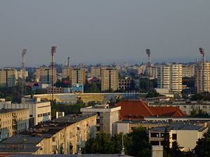
Municipal Stadium (Bacău)
Distance: Approx. 1435 meters
Latitude and longitude: 46.55722222,26.91333333
The Bacău Municipal Stadium is a multi-use stadium in Bacău. It holds 17,500 people and it is the 19th stadium in the country.
Limpedea
River in Bacău County, Romania
Distance: Approx. 2456 meters
Latitude and longitude: 46.5909,26.9017
The Limpedea is a left tributary of the river Trebeș in Romania. It flows into the Trebeș near the city Bacău. Its length is 16 km (9.9 mi) and its basin size is 47 km2 (18 sq mi).
Negel (river)
River in Bacău County, Romania
Distance: Approx. 2917 meters
Latitude and longitude: 46.5775,26.87583333
The Negel is a right tributary of the river Trebeș in Romania. It flows into the Trebeș near Mărgineni. Its length is 13 km (8.1 mi) and its basin size is 26 km2 (10 sq mi).

Letea Veche
Commune in Bacău, Romania
Distance: Approx. 3645 meters
Latitude and longitude: 46.55,26.95
Letea Veche is a commune in Bacău County, Western Moldavia, Romania. It is composed of five villages: Holt, Letea Veche, Radomirești, Ruși-Ciutea and Siretu.

Vasile Alecsandri University of Bacău
Distance: Approx. 1770 meters
Latitude and longitude: 46.554212,26.913432
The Vasile Alecsandri University of Bacău (Romanian: Universitatea „Vasile Alecsandri” din Bacău) is a public university in Romania, located in Bacău. Named in honor of the poet Vasile Alecsandri, it was founded in 1990.
Trebeș
River in Romania
Distance: Approx. 862 meters
Latitude and longitude: 46.57194444,26.92333333
The Trebeș is a right tributary of the river Bistrița in Romania. It discharges into the Bistrița in Bacău. Its length is 28 km (17 mi) and its basin size is 184 km2 (71 sq mi).
Ferdinand I National College
Distance: Approx. 502 meters
Latitude and longitude: 46.5695,26.9059
Ferdinand I National College (Romanian: Colegiul Național "Ferdinand I") is a high school in Bacău, Romania, located at 45 George Bacovia Street. Established in 1867, the school's early years were marked by a lack of faculty, a permanent building and teaching material. The first graduating class finished in 1871, and the first dedicated building was finished in 1891.

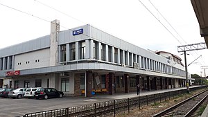
Bacău railway station
Distance: Approx. 1405 meters
Latitude and longitude: 46.56555556,26.89527778
Bacău railway station (Romanian: Gara Bacău) is the largest train station in the city of Bacău, Romania, and one of the most important in the north-east of the country.

Vasile Alecsandri National College (Bacău)
Distance: Approx. 918 meters
Latitude and longitude: 46.562357,26.908273
Vasile Alecsandri National College (Romanian: Colegiul Național "Vasile Alecsandri") is a public day high school in Bacău, Romania, located at 37 Vasile Alecsandri Street. Founded as a secondary school for girls in 1921, work on the building lasted from 1925 to 1934. Today, this is considered a historic monument by Romania's Ministry of Culture and Religious Affairs.

Old Jewish Cemetery, Bacău
Closed cemetery in Bacău, Romania
Distance: Approx. 1230 meters
Latitude and longitude: 46.55944444,26.91666667
The Old Jewish Cemetery in Bacău, Romania is a closed cemetery that was used by the Jewish community of the city from at least the early 18th century until 1917, when the New Jewish Cemetery was opened. The cemetery is located in the center of Bacau, bordered by Pictor Theodor Aman Street from the north and Ghioceilor street in the east, just a few meters from the Athletics Hall, the Bacovia University and the Zimbru neighborhood. Among others, were also buried here former participants in the Romanian War of Independence of 1877.

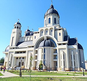
Cathedral of the Lord's Ascension, Bacău
Church in Bacău, Romania
Distance: Approx. 142 meters
Latitude and longitude: 46.57,26.91055556
The Church of the Ascension of the Lord (Romanian: Biserica Înălțarea Domnului) is a church in Bacău, Romania and is the third largest cathedral in the country, after the People's Salvation Cathedral of Bucharest and the Holy Trinity Cathedral of Baia Mare. Officially the structure is a church and not a cathedral, because Bacău is not the seat of any bishop (the cathedral of the Bishop of Roman and Bacău, from which this parochial church belongs, being in Roman). However, due to its size and importance, it is called by the locals "cathedral" – in the sense used in the primary Christianity, that of the main place of the city.
Weather in this IP's area
few clouds
12 Celsius
11 Celsius
12 Celsius
12 Celsius
995 hPa
63 %
995 hPa
976 hPa
10000 meters
8.05 m/s
160 degree
20 %
07:21:55
16:34:29