89.39.145.63 - IP Lookup: Free IP Address Lookup, Postal Code Lookup, IP Location Lookup, IP ASN, Public IP
Country:
 Serbia
Region:
City:
Location:
Time Zone:
Postal Code:
ISP:
ASN:
language:
User-Agent:
Proxy IP:
Blacklist:
IP information under different IP Channel
ip-api
Country
Region
City
ASN
Time Zone
ISP
Blacklist
Proxy
Latitude
Longitude
Postal
Route
db-ip
Country
Region
City
ASN
Time Zone
ISP
Blacklist
Proxy
Latitude
Longitude
Postal
Route
IPinfo
Country
Region
City
ASN
Time Zone
ISP
Blacklist
Proxy
Latitude
Longitude
Postal
Route
IP2Location
89.39.145.63Country
rsRegion
nisavski okrug
City
nis
Time Zone
Europe/Belgrade
ISP
Language
User-Agent
Latitude
Longitude
Postal
ipdata
Country
Region
City
ASN
Time Zone
ISP
Blacklist
Proxy
Latitude
Longitude
Postal
Route
Popular places and events near this IP address

Niš
City in southern Serbia
Distance: Approx. 723 meters
Latitude and longitude: 43.32083333,21.89583333
Niš (; Serbian Cyrillic: Ниш, Serbian pronunciation: [nîːʃ] ; names in other languages), less often spelled in English as Nish, is the third largest city in Serbia and the administrative center of the Nišava District. It is located in the southern part of Serbia. According to the 2011 census, the city proper has a population of 182,797, while its administrative area (City of Niš) has a population of 260,237 inhabitants.
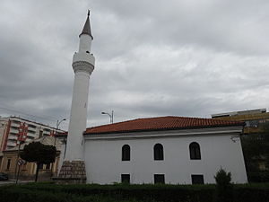
Islam-aga's Mosque
Mosque in Niš, Nišava, Serbia
Distance: Approx. 926 meters
Latitude and longitude: 43.320456,21.893153
Islam-aga's Mosque (Serbian: Ислам-агина џамија) is the only working mosque in Niš, Serbia. There is another in Niš Fortress which is converted into a gallery, and another close to the University Rectorate, that was damaged during the Anglo-American bombing of the city in 1944. It was built in 1720 and reconstructed in 1870.

University of Niš
University in Serbia
Distance: Approx. 799 meters
Latitude and longitude: 43.32305556,21.89333333
The University of Niš (Serbian: Универзитет у Нишу, romanized: Univerzitet u Nišu) is a public university in Serbia. It was founded in 1965. As of the 2018-19 school year, it consists of 13 faculties with 1,492 academic staff and around 20,500 students.

Medijana
City municipality in Southern and Eastern Serbia, Serbia
Distance: Approx. 935 meters
Latitude and longitude: 43.31666667,21.9
Medijana (Serbian Cyrillic: Медијана) is one of five city municipalities which constitute the city of Niš. It is the central and the most populous city municipality of Niš with the population of 85,969 inhabitants.

Čair Stadium
Multipurpose stadium in Niš, Serbia
Distance: Approx. 1129 meters
Latitude and longitude: 43.31552778,21.90853333
Čair Stadium (Serbian Cyrillic: Стадион Чаир, Stadion Čair) is a multi-purpose stadium in Niš, Serbia. It is used mostly for football matches and is the home ground of Radnički Niš. After a partial reconstruction that began in 2011, the renovated stadium re-opened to the public on 15 September 2012.
Beograd Mala
Neighborhood in Serbia
Distance: Approx. 1022 meters
Latitude and longitude: 43.324522,21.89028
Beograd Mala (Serbian Cyrillic: Београд Maлa) is a neighborhood of the city of Niš, Serbia. It is located in Niš municipality of Crveni Krst.

Čair Sports Center
Sports arena in Niš, Serbia
Distance: Approx. 960 meters
Latitude and longitude: 43.31694444,21.90777778
Čair Sports Center (Serbian: Спортски центар Чаир, romanized: Sportski centar Čair), commonly known as Čair Hall (Serbian: Хала Чаир, romanized: Hala Čair) is an indoor sporting arena located in Niš, Serbia. The seating capacity of the arena is 4,800 for sports events and 6,500 at concerts. It is home to the KK Konstantin basketball team, RK Železničar 1949 handball team and OK Niš volleyball team.

National Theatre in Niš
Distance: Approx. 533 meters
Latitude and longitude: 43.3205,21.9
The National Theatre (Serbian: Народно позориште у Нишу, romanized: Narodno Pozorište u Nišu) is a theater located in Sinđelić Square, Niš, Serbia. It was founded in 1887 as "Sinđelić" Theatre, and reorganized in 1906 as National Theatre, following the completion of new theatre building.

Ambasador Hotel
Hotel in central Niš, Serbia
Distance: Approx. 657 meters
Latitude and longitude: 43.321,21.8967
Ambasador Hotel is a landmark hotel in the center of Niš, Serbia. It is the only 5-star hotel in the city. First opened in 1968, Ambasador Hotel was the tallest building in Niš until the construction of the TV5 high-rise in 1973.

University of Niš Faculty of Arts
Distance: Approx. 799 meters
Latitude and longitude: 43.32305556,21.89333333
The Faculty of Arts in Niš (Serbian: Факултет уметности Универзитета у Нишу, romanized: Fakultet umetnosti Univerziteta u Nišu) is an independent department of the University of Niš in Niš, Serbia. The Faculty was established on 3 October 2002 by the Government of Serbia.

Historical Archive of Niš
Distance: Approx. 733 meters
Latitude and longitude: 43.32658,21.89418
The Historical Archive of Niš (Serbian Cyrillic: Историјски архив Ниш) is the primary institution responsible for preservation of archival materials in the Nišava District located in Niš, Serbia. The archive is primarily covering municipalities of Niš, Merošina, Sokobanja, Ražanj, Doljevac, Aleksinac, Svrljig and Gadžin Han. The oldest documents kept at the archive are related to Habsburg occupation of Serbia in 1730s.

Battle of Niš (1915)
1915 battle during World War I
Distance: Approx. 723 meters
Latitude and longitude: 43.32083333,21.89583333
The Battle of Niš was a military engagement between the army of the Kingdom of Bulgaria with support from the German Empire against the Kingdom of Serbia in November 1915, during the Central Powers Morava Offensive of World War I. City of Niš, serving as a capital of Serbia after the fall of Belgrade, was captured between 4 and 5 November 1915 by the forces of 9th Pleven Division of Bulgarian First Army. The fall of Niš had a huge psychological impact on both of fighting sides: Serbians were forced to continue in their Great Retreat, for Central Powers the victory ment removing the last obstacle for operating the Berlin–Baghdad railway, the shortest railway connection between Germany, Austria-Hungary and the Ottoman Empire.
Weather in this IP's area
clear sky
-8 Celsius
-8 Celsius
-8 Celsius
-8 Celsius
1032 hPa
86 %
1032 hPa
980 hPa
10000 meters
1.03 m/s