Country:
Region:
City:
Latitude and Longitude:
Time Zone:
Postal Code:
IP information under different IP Channel
ip-api
Country
Region
City
ASN
Time Zone
ISP
Blacklist
Proxy
Latitude
Longitude
Postal
Route
Luminati
Country
ASN
Time Zone
Europe/Bucharest
ISP
Livehosting Datacenter Srl
Latitude
Longitude
Postal
IPinfo
Country
Region
City
ASN
Time Zone
ISP
Blacklist
Proxy
Latitude
Longitude
Postal
Route
db-ip
Country
Region
City
ASN
Time Zone
ISP
Blacklist
Proxy
Latitude
Longitude
Postal
Route
ipdata
Country
Region
City
ASN
Time Zone
ISP
Blacklist
Proxy
Latitude
Longitude
Postal
Route
Popular places and events near this IP address

Timișoara
City and county seat in Timiș County, Romania
Distance: Approx. 1912 meters
Latitude and longitude: 45.75972222,21.23
Timișoara (UK: , US: , Romanian: [timiˈʃo̯ara] ; German: Temeswar [ˈtɛmɛʃvaːɐ̯] , also Temeschwar or Temeschburg; Hungarian: Temesvár [ˈtɛmɛʃvaːr] ; Serbian: Темишвар, romanized: Temišvar [těmiʃʋaːr]; see other names) is the capital city of Timiș County, Banat, and the main economic, social and cultural centre in Western Romania. Located on the Bega River, Timișoara is considered the informal capital city of the historical Banat region. From 1848 to 1860 it was the capital of the Serbian Vojvodina and the Voivodeship of Serbia and Banat of Temeschwar.

Vest (development region)
Region in Romania
Distance: Approx. 1912 meters
Latitude and longitude: 45.75972222,21.23
Vest (English: West) is a development region in Romania created in 1998. As with the other development regions, it does not have any administrative powers. Its primary functions are coordinating regional development projects and managing funds from the European Union.
Iulius Town Timișoara
Romanian shopping mall
Distance: Approx. 1243 meters
Latitude and longitude: 45.7664,21.2281
Iulius Town Timișoara (until 2019 Openville Timișoara) is the name of a mixed-use development, edge city and shopping mall located in Timișoara, Romania. Owned by the Iulius Group–Atterbury Europe consortium, the project was conceived from the beginning to integrate Iulius Mall, now completed with office, retail and entertainment functions. The mixed project includes, in addition to the shopping area, a park, event rooms, offices, a health center, a cinema and over 4,000 parking spaces.

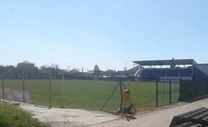
Electrica Stadium
Romanian stadium
Distance: Approx. 1756 meters
Latitude and longitude: 45.76902778,21.25444444
Electrica Stadium (Romanian: Stadionul Electrica) is a multi-purpose stadium in Timișoara, Romania. It is currently used mostly for football matches and is the home ground of Electrica Timișoara and Ripensia Timișoara. The stadium holds 5,000 people and is located in the Fabric district.
Siege of Temesvár (1849)
Distance: Approx. 1913 meters
Latitude and longitude: 45.75972194,21.23
The siege of Temesvár (today: Timișoara, Romania) was a siege during the Hungarian Revolution of 1848 between the Austrian Empire and Hungarian Revolutionary Army. The Hungarians unsuccessfully tried to capture the Timișoara Fortress. The siege ended with the Battle of Temesvár.
Stadionul UMT
Former Romanian stadium
Distance: Approx. 1678 meters
Latitude and longitude: 45.77041667,21.25430556
UMT Stadium (Romanian: Stadionul UMT) was a multi-purpose stadium in Timișoara, Romania. Until 1960 the stadium was known as Stadionul Electrica and was the main home ground in Timișoara for athletics championships, being also the stadium where Olympic champion Iolanda Balaș made her debut. Ripensia Timișoara (until 1948) and Electrica Timișoara (until 1960) also used the stadium as the home ground for football matches.

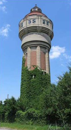
Fabric Water Tower
Water tower in Timișoara, Romania
Distance: Approx. 1761 meters
Latitude and longitude: 45.76555556,21.25083333
The Fabric Water Tower (Romanian: Turnul de apă din Fabric) is an industrial monument in Timișoara, Romania. It was one of the sources of water supply in Timișoara at the beginning of the 20th century. It is classified as a national heritage site (Romanian: monument istoric) with LMI code TM-II-m-A-06122.
Torontalului
District in northwestern Timișoara
Distance: Approx. 1778 meters
Latitude and longitude: 45.7748611,21.2118313
Torontalului is a district in northwestern Timișoara. Its name comes from the homonymous road (Calea Torontalului) that crosses it. In turn, Torontal was the name of a county in the Kingdom of Hungary which, after being conquered, liberated and disputed by Turks, Serbs, Hungarians and Romanians, was divided between the last three, a small part entering Timiș-Torontal County, an administrative unit in the Kingdom of Romania.
UMT–Pădurea Verde
Distance: Approx. 1784 meters
Latitude and longitude: 45.7711929,21.2562307
UMT–Pădurea Verde is a district of Timișoara located near the Green Forest and the former Timișoara Mechanical Plants (Romanian: Uzinele Mecanice Timișoara, abbreviated UMT). Founded in 1960 by the merger of two factories in the city, the Timișoara Mechanical Plants were bought in 2018 by Continental AG, a German multinational automotive manufacturer which has been operating since the early 2000s near the former industrial platform. The Banat Village Museum and the Zoological Garden are located in this district.

Timișoara East railway station
Distance: Approx. 1344 meters
Latitude and longitude: 45.76666667,21.24444444
Timișoara East railway station, previously known as Fabric railway station, is one of the five stations of Timișoara. Timișoara East is the second most important station in the city, after Timișoara North. The station is transited daily by 15 trains operated by CFR Călători.

Fidelity Column
Monument in Heroes' Cemetery, Timișoara, Romania
Distance: Approx. 1057 meters
Latitude and longitude: 45.76888889,21.22666667
Fidelity Column, also known as Victory Monument, is a statue located in Heroes' Cemetery of Timișoara's Lipovei district. The statue was donated to Timișoara in 1853 by Emperor Franz Joseph I as a sign of his gratitude for the resistance shown during the Hungarian Revolution and War of Independence of 1848–1849. It is inscribed in the list of historical monuments with the code TM-IV-m-A-06330.
Timișoara Prison
Prison located in Romania
Distance: Approx. 1644 meters
Latitude and longitude: 45.76194444,21.23194444
Timișoara Prison is a prison located in Timișoara, Romania. It is intended for convicts with sentences of up to three years, classified under open regime, semi-open regime and preventive detention.
Weather in this IP's area
overcast clouds
6 Celsius
5 Celsius
6 Celsius
8 Celsius
1015 hPa
65 %
1015 hPa
1004 hPa
7000 meters
1.54 m/s
280 degree
100 %
07:39:28
17:01:25