Country:
 Romania
Region:
City:
Latitude and Longitude:
Time Zone:
Postal Code:
IP information under different IP Channel
ip-api
Country
Region
City
ASN
Time Zone
ISP
Blacklist
Proxy
Latitude
Longitude
Postal
Route
IPinfo
Country
Region
City
ASN
Time Zone
ISP
Blacklist
Proxy
Latitude
Longitude
Postal
Route
MaxMind
Country
Region
City
ASN
Time Zone
ISP
Blacklist
Proxy
Latitude
Longitude
Postal
Route
Luminati
Country
ROASN
Time Zone
Europe/Bucharest
ISP
Next Start Srl
Latitude
Longitude
Postal
db-ip
Country
Region
City
ASN
Time Zone
ISP
Blacklist
Proxy
Latitude
Longitude
Postal
Route
ipdata
Country
Region
City
ASN
Time Zone
ISP
Blacklist
Proxy
Latitude
Longitude
Postal
Route
Popular places and events near this IP address
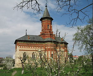
Hârlău
Town in Iași, Romania
Distance: Approx. 698 meters
Latitude and longitude: 47.42777778,26.91138889
Hârlău (also spelled Hîrlău, Romanian pronunciation: [hɨrˈləw]; Hebrew: חרלאו; Hungarian: Harló) is a town in Iași County, Western Moldavia, Romania. It was one of the princely court cities of Moldavia, in the 15th century. One village, Pârcovaci, is administered by the town.

Cotnari
Commune in Iași, Romania
Distance: Approx. 9947 meters
Latitude and longitude: 47.34027778,26.94083333
Cotnari (Romanian pronunciation: [kotˈnarʲ]) is a village and the center of the eponymous commune in Iași County, Romania, in the historical region of Western Moldavia. It is located north-west of Iași and south of Hârlău, in a major wine-producing region of Romania, and is famous for the wine variety known as Grasă de Cotnari. Cârjoaia, the forest of Dumbrava Roșie, and other sites in Cotnari are regional tourist spots.
Buhalnița (Bahlui)
River in Iași County, Romania
Distance: Approx. 8089 meters
Latitude and longitude: 47.3698,26.971
The Buhalnița is a right tributary of the river Bahlui in Romania. It flows into the Bahlui in Ceplenița. Its length is 16 km (9.9 mi) and its basin size is 33 km2 (13 sq mi).

Ceplenița
Commune in Iași, Romania
Distance: Approx. 9809 meters
Latitude and longitude: 47.38333333,27.01666667
Ceplenița is a commune in Iași County, Western Moldavia, Romania. It is composed of four villages: Buhalnița, Ceplenița, Poiana Mărului and Zlodica. It is 9.3 kilometres (5.8 mi) from Hârlău town.

Deleni, Iași
Commune in Iași, Romania
Distance: Approx. 4775 meters
Latitude and longitude: 47.46666667,26.88333333
Deleni is a commune in Iași County, Western Moldavia, Romania. It is composed of six villages: Deleni, Feredeni, Leahu-Nacu, Maxut, Poiana and Slobozia.

Scobinți
Commune in Iași, Romania
Distance: Approx. 5264 meters
Latitude and longitude: 47.38333333,26.93333333
Scobinți is a commune in Iași County, Western Moldavia, Romania. It is composed of five villages: Bădeni, Fetești, Scobinți, Sticlăria and Zagavia.
Dacian fortress of Cotnari
Distance: Approx. 9959 meters
Latitude and longitude: 47.34,26.94
It was a Dacian fortified town.
Weather in this IP's area
clear sky
15 Celsius
13 Celsius
14 Celsius
16 Celsius
1021 hPa
39 %
1021 hPa
1005 hPa
10000 meters
2.05 m/s
1.99 m/s
333 degree
06:40:53
19:39:28