89.28.255.25 - IP Lookup: Free IP Address Lookup, Postal Code Lookup, IP Location Lookup, IP ASN, Public IP
Country:
Region:
City:
Location:
Time Zone:
Postal Code:
ISP:
ASN:
language:
User-Agent:
Proxy IP:
Blacklist:
IP information under different IP Channel
ip-api
Country
Region
City
ASN
Time Zone
ISP
Blacklist
Proxy
Latitude
Longitude
Postal
Route
db-ip
Country
Region
City
ASN
Time Zone
ISP
Blacklist
Proxy
Latitude
Longitude
Postal
Route
IPinfo
Country
Region
City
ASN
Time Zone
ISP
Blacklist
Proxy
Latitude
Longitude
Postal
Route
IP2Location
89.28.255.25Country
Region
magadanskaya oblast'
City
magadan
Time Zone
Asia/Magadan
ISP
Language
User-Agent
Latitude
Longitude
Postal
ipdata
Country
Region
City
ASN
Time Zone
ISP
Blacklist
Proxy
Latitude
Longitude
Postal
Route
Popular places and events near this IP address

Magadan
City in Magadan Oblast, Russia
Distance: Approx. 4 meters
Latitude and longitude: 59.56666667,150.8
Magadan (Russian: Магадан, IPA: [məɡɐˈdan]) is a port town and the administrative centre of Magadan Oblast, Russia. The city is located on the isthmus of the Staritsky Peninsula by the Nagaev Bay; it serves as a gateway to the Kolyma region. Magadan, founded in 1929, was a major transit centre for political prisoners during the Stalin era and the administrative centre of the Dalstroy forced-labor gold-mining operation.

R504 Kolyma Highway
Road in eastern Russia
Distance: Approx. 2995 meters
Latitude and longitude: 59.58828889,150.8317
The R504 Kolyma Highway (Russian: Федеральная автомобильная дорога «Колыма», Federal'naya Avtomobil'naya Doroga «Kolyma», "Federal Automobile Highway 'Kolyma'"), part of the M56 route, is a road through the Russian Far East. It connects Magadan with the town of Nizhny Bestyakh, located on the eastern bank of the Lena River, opposite of Yakutsk. At Nizhny Bestyakh the Kolyma Highway connects to the Lena Highway.

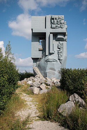
Mask of Sorrow
Monument in Magadan, Russia
Distance: Approx. 2881 meters
Latitude and longitude: 59.59183889,150.812125
The Mask of Sorrow (Russian: Маска скорби, romanized: Maska skorbi) is a monument located on a hill above Magadan, Russia, commemorating the many prisoners who suffered and died in the Gulag prison camps in the Kolyma region of the Soviet Union during the 1930s, 1940s, and 1950s. It consists of a large concrete statue of a face, with tears coming from the left eye in the form of small masks. The right eye is in the form of a barred window.
Magadan-13 Airport
Airport in Magadan
Distance: Approx. 9313 meters
Latitude and longitude: 59.62333333,150.92166667
Magadan-13 Airport (Russian: Аэропорт Магадан-13) (ICAO: UHMT) is a small airport in Russia located 10 km northeast of Magadan. It handles most propeller-driven transports. Regular passenger Ilyushin Il-14 aircraft were flying here in the 1950s and early 1960s.

Church of the Nativity (Magadan)
Church in Magadan, Russia
Distance: Approx. 2251 meters
Latitude and longitude: 59.5539,150.8309
The Church of the Nativity at Magadan in the Russian Far East serves local Roman Catholics, many of whom survived Joseph Stalin's forced labor camps set up in the 1930s, 1940s and 1950s to exploit gold in Kolyma's harsh subarctic climate. Today the church stands both as a monument to the millions who died or suffered in the camps and as a source of inspiration for the local population. The church was built largely through the efforts of Father Michael Shields of Anchorage, Alaska who went to Magadan in 1994 specifically to care for those who had suffered in the camps.

Nagayevo, Magadan
Place in Magadan Oblast, Russia
Distance: Approx. 2083 meters
Latitude and longitude: 59.55,150.78333333
Nagayevo (Russian: Нага́ево) was an urban-type settlement on the shore of Nagayev Bay of the Sea of Okhotsk in what later became present day Magadan Oblast, in the Russian Far East. Presently, Nagayevo is a microdistrict in and the port area of the city of Magadan, the administrative center of Magadan Oblast.

Nagaev Bay
Distance: Approx. 7393 meters
Latitude and longitude: 59.54,150.68
Nagaev Bay or Nagayev Bay (Russian: Бухта Нагаева, Нагаевская бухта), also known as Nagayeva Bay, is a bay within Taui Bay in the northern part of the Sea of Okhotsk, Magadan Oblast, Russia.

Port of Magadan
Port in Russia
Distance: Approx. 3401 meters
Latitude and longitude: 59.53916667,150.77388889
The Port of Magadan (Russian: Морской порт Магадан, romanized: Morskoi port Magadan) is a maritime port in the city of Magadan, Magadan Oblast, Russia, located in the Nagaev Bay on the northern coast of the Sea of Okhotsk. The port has 13 berths, of which 3 are for oil products, container 2, and 8 for other goods.

Staritsky Peninsula
A peninsula in the Sea of Okhotsk, Russian Far East
Distance: Approx. 7660 meters
Latitude and longitude: 59.5,150.83333333
The Staritsky Peninsula projects into the Taui Bay of the Sea of Okhotsk in Magadan Oblast, Russian Far East immediately south of Magadan, which occupies the isthmus of the peninsula. It is separated from the mainland by the smaller Nagayev Bay on the west and Gertner Bay on the east. Before 1875 the it was known as the Miyekan Peninsula after the local even's name Miyekan for the Nagayev bay.

North-Eastern State University
Distance: Approx. 464 meters
Latitude and longitude: 59.5644144,150.7931262
North-Eastern State University (Russian: Северо-Восточный государственный университет) is a public university in Magadan, the capital city of Magadan Oblast located in the Russian Far East.
Weather in this IP's area
overcast clouds
-17 Celsius
-17 Celsius
-17 Celsius
-17 Celsius
1013 hPa
83 %
1013 hPa
1005 hPa
10000 meters
1 m/s
1.01 m/s
60 degree
100 %