Country:
 Russian Federation
Region:
City:
Latitude and Longitude:
Time Zone:
Postal Code:
IP information under different IP Channel
ip-api
Country
Region
City
ASN
Time Zone
ISP
Blacklist
Proxy
Latitude
Longitude
Postal
Route
IPinfo
Country
Region
City
ASN
Time Zone
ISP
Blacklist
Proxy
Latitude
Longitude
Postal
Route
MaxMind
Country
Region
City
ASN
Time Zone
ISP
Blacklist
Proxy
Latitude
Longitude
Postal
Route
Luminati
Country
RUASN
Time Zone
Europe/Moscow
ISP
JSC Telecommunication company Convey Plus
Latitude
Longitude
Postal
db-ip
Country
Region
City
ASN
Time Zone
ISP
Blacklist
Proxy
Latitude
Longitude
Postal
Route
ipdata
Country
Region
City
ASN
Time Zone
ISP
Blacklist
Proxy
Latitude
Longitude
Postal
Route
Popular places and events near this IP address
Fontanka
Left branch of the river Neva in Saint Petersburg, Russia
Distance: Approx. 2078 meters
Latitude and longitude: 59.91666667,30.27833333
The Fontanka (Russian: Фонтанка), a left branch of the river Neva, flows through the whole of Central Saint Petersburg, Russia – from the Summer Garden to Gutuyevsky Island. It is 6.7 kilometres (4.2 mi) long, with a width up to 70 metres (230 ft), and a depth up to 3.5 metres (11 ft). The Moyka River forms a right-bank branch of the Fontanka.
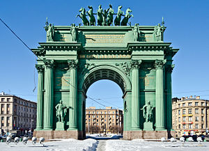
Narva Triumphal Arch
Arch in Saint Petersburg, Russia
Distance: Approx. 1712 meters
Latitude and longitude: 59.9009,30.2738
The Narva Triumphal Arch (Russian: На́рвские триумфа́льные ворота, lit. Narvskie Triumfal'nyye vorota) was erected in the vast Stachek Square (prior to 1923 also known as the Narva Square), Saint Petersburg, in 1814 to commemorate the Russian victory over Napoleon. The wooden structure was constructed on the then highway to Narva with the purpose of greeting the soldiers who were returning from abroad after their victory over Napoleon.

Admiralty Shipyards
Shipyard in Saint Petersburg, Russia
Distance: Approx. 1976 meters
Latitude and longitude: 59.91916667,30.2725
The JSC Admiralty Shipyards (Russian: Адмиралтейские верфи) (formerly Soviet Shipyard No. 194) is one of the oldest and largest shipyards in Russia, located in Saint Petersburg. The shipyard's building ways can accommodate ships of up to 70,000 tonnes deadweight (DWT), 250 metres (820 ft) in length and 35 metres (115 ft) in width.
Admiralteysky Municipal Okrug
Distance: Approx. 1799 meters
Latitude and longitude: 59.894,30.264
Admiralteysky Municipal Okrug (Russian: Адмиралте́йский муниципа́льный о́круг) is a municipal okrug of Admiralteysky District of the federal city of St. Petersburg, Russia. Population: 22,634 (2010 Census); 30,533 (2002 Census).

Catherinehof
Building
Distance: Approx. 922 meters
Latitude and longitude: 59.903,30.26
Ekaterinhof or Catherinehof (Russian: Екатеринго́ф < German: Katharinenhof "Catherine's Court") is a historic island park that began as an 18 century empress's estate in the south-west of St Petersburg, Russia. Its name originated in 1711, when Peter the Great presented the Island and adjacent lands along the eponymous Ekateringofka River to his wife Catherine (Catherine I of Russia), whose name they memorialize. The emperor apparently conceived Catherinehof as the first imperial estate located on the road leading from the capital to his main summer residence, Peterhof.

Obvodny Canal
Canal in Russia
Distance: Approx. 842 meters
Latitude and longitude: 59.9093,30.2606
Obvodny Canal (Russian: Обводный канал, lit. Bypass Canal) is the longest canal in Saint Petersburg, Russia, which in the 19th century served as the southern limit of the city. It is 8 kilometres (5 mi) long and flows from the Neva River near Alexander Nevsky Lavra to the Yekaterinhofka not far from the sea port.
St. Petersburg Christian University
University in Saint Petersburg, Russia
Distance: Approx. 1477 meters
Latitude and longitude: 59.9047,30.2719
St. Petersburg Christian University (SPbCU) is an interdenominational Evangelical Christian University located in St. Petersburg, Russia.

Narvskaya
Saint Petersburg Metro Station
Distance: Approx. 1754 meters
Latitude and longitude: 59.90120833,30.27490278
Narvskaya (Russian: На́рвская) is a subway station in Saint Petersburg, Russia on the Kirovsko-Vyborgskaya Line between the stations Baltiyskaya and Kirovsky Zavod. The station was opened on 15 November 1955, as a part of the first stage of Saint Petersburg Metro from Avtovo to Ploschad Vosstania.
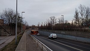
Kanonersky Tunnel
Distance: Approx. 1275 meters
Latitude and longitude: 59.90361111,30.22444444
Kanonersky Tunnel (Russian: Канонерский тоннель) is a tunnel under the Sea Canal in the Kirovsky District of Saint Petersburg. The tunnel provides a link between Kanonersky Island and Dvinskaya Street on Gutuevsky Island. The tunnel was constructed in 1983 by using Immersed tube method.
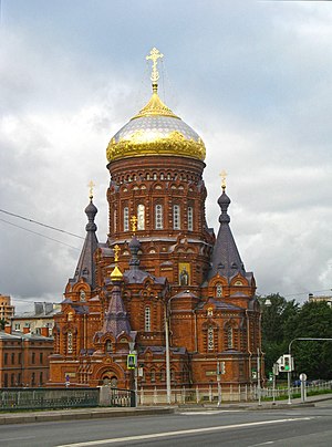
Church of the Epiphany (Saint Petersburg)
Church in Saint Petersburg, Russia
Distance: Approx. 639 meters
Latitude and longitude: 59.909,30.257
The Church of the Epiphany is an Orthodox Church on Gutuevsky Island, Saint Petersburg. It was designed by Vasily Kosyakov and built in 1888.

Narvsky Municipal Okrug
Municipal okrug in St. Petersburg, Russia
Distance: Approx. 1418 meters
Latitude and longitude: 59.9,30.26666667
Narvsky Municipal Okrug (Russian: На́рвский муниципа́льный о́круг) is a municipal okrug in Kirovsky District, one of the eighty-one low-level municipal divisions of the federal city of St. Petersburg, Russia. As of the 2010 Census, its population was 30,810, up from 29,822 recorded during the 2002 Census.

Municipal Okrug 72
Municipal okrug in St. Petersburg, Russia
Distance: Approx. 1418 meters
Latitude and longitude: 59.9,30.26666667
Municipal Okrug 72 (Russian: Муниципальный округ № 72) is a municipal okrug in Frunzensky District, one of the eighty-one low-level municipal divisions of the federal city of St. Petersburg, Russia. As of the 2010 Census, its population was 68,333.
Weather in this IP's area
clear sky
11 Celsius
10 Celsius
11 Celsius
11 Celsius
1030 hPa
50 %
1030 hPa
1029 hPa
10000 meters
3 m/s
220 degree
07:48:21
17:39:11