Country:
 Norway
Region:
City:
Latitude and Longitude:
Time Zone:
Postal Code:
IP information under different IP Channel
ip-api
Country
Region
City
ASN
Time Zone
ISP
Blacklist
Proxy
Latitude
Longitude
Postal
Route
IPinfo
Country
Region
City
ASN
Time Zone
ISP
Blacklist
Proxy
Latitude
Longitude
Postal
Route
MaxMind
Country
Region
City
ASN
Time Zone
ISP
Blacklist
Proxy
Latitude
Longitude
Postal
Route
Luminati
Country
NOASN
Time Zone
Europe/Oslo
ISP
Orange Business Digital Norway As
Latitude
Longitude
Postal
db-ip
Country
Region
City
ASN
Time Zone
ISP
Blacklist
Proxy
Latitude
Longitude
Postal
Route
ipdata
Country
Region
City
ASN
Time Zone
ISP
Blacklist
Proxy
Latitude
Longitude
Postal
Route
Popular places and events near this IP address
Ullensaker
Municipality in Akershus, Norway
Distance: Approx. 3820 meters
Latitude and longitude: 60.17083333,11.18805556
Ullensaker is a municipality in Akershus county, Norway. It is part of the traditional region of Romerike. The administrative centre of the municipality is the city of Jessheim.

Romerike
District in Akershus, Norway
Distance: Approx. 4660 meters
Latitude and longitude: 60.1,11.2
Romerike is a traditional district located north-east of Oslo, in what is today south-eastern Norway. It consists of the Akershus municipalities Lillestrøm, Lørenskog, Nittedal, Rælingen and Aurskog-Høland in the southern end (Nedre Romerike), and Ullensaker, Gjerdrum, Nannestad, Nes, Eidsvoll and Hurdal in the northern end (Øvre Romerike).

Gardermoen Line
Railway line in Norway
Distance: Approx. 2415 meters
Latitude and longitude: 60.1572,11.1447
The Gardermoen Line (Norwegian: Gardermobanen) is a high-speed railway line between Oslo and Eidsvoll, Norway, running past Lillestrøm and Oslo Airport, Gardermoen. The line is 64 kilometres (40 mi) long and replaced the older Hoved Line as the main line north-east of Oslo. The older Hoved Line now handles commuter and freight traffic, while the Gardermoen Line handles high-speed passenger trains and freight trains laden with jet fuel for the airport.

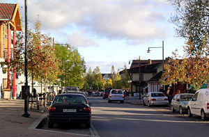
Jessheim
Town in Viken, Norway
Distance: Approx. 1615 meters
Latitude and longitude: 60.15,11.18333333
Jessheim is a town in the Ullensaker municipality in Akershus of Norway.

Jessheim Storsenter
Distance: Approx. 649 meters
Latitude and longitude: 60.14277778,11.17361111
Jessheim Storsenter is a shopping centre located in the centre of Jessheim, Norway. The shopping centre was originally opened in 1968 under the name of Fakkelsenteret. The name roughly translates as 'the torch centre' and it had a sculpture of the Roman goddess Vesta holding a torch that originally was lit by a natural gas flame.

Jessheim Station
Railway station in Ullensaker, Norway
Distance: Approx. 743 meters
Latitude and longitude: 60.14222222,11.17694444
Jessheim Station (Norwegian: Jessheim stasjon) is a railway station at Jessheim which opened in 1854. It is 44.60 kilometers (27.71 mi) from Oslo Central Station and has an elevation of 203.8 meters (669 ft) above mean sea level. The station is part of Norway's first railway, the Trunk Line, which ran from Kristiania (today known as Oslo) to Eidsvoll.
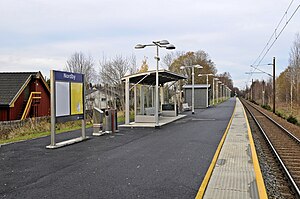
Nordby Station
Railway station in Ullensaker, Norway
Distance: Approx. 2077 meters
Latitude and longitude: 60.15527778,11.18166667
Nordby Station is a railway station located two kilometers north of Jessheim in Ullensaker, Norway on the Trunk Line. The station was built in 1932 and is served by the Oslo Commuter Rail R13 from Drammen via Oslo S to Dal.
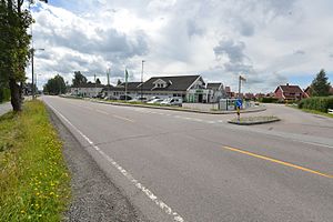
Sand, Akershus
Village in Østlandet, Norway
Distance: Approx. 2782 meters
Latitude and longitude: 60.15444444,11.12777778
Sand is a village in Ullensaker municipality in Akershus, Norway. The village lies halfway between Gardermoen and Jessheim. The village was previously its own urban area, but now is part of the urban area of Jessheim.

Norwegian County Road 174
Road in Norwegia
Distance: Approx. 4159 meters
Latitude and longitude: 60.14166667,11.24083333
Norwegian County Road 174 (Norwegian: Fylkesvei 174) is 11.8 kilometers (7.3 mi) long and runs between Nordby and Dalstua in Ullensaker, Norway. Prior to 1 January 2010, it was known as National Road 174 (Riksvei 174).
Norwegian County Road 178
Road in Ullensaker, Norway
Distance: Approx. 4152 meters
Latitude and longitude: 60.13305556,11.09194444
County Road 178 (Norwegian: Fylkesvei 178 or Fv178) runs between Eltonåsen in Nannestad and Jessheim in Ullensaker, Norway. The road is 11.1 kilometers (6.9 mi) long. Prior to 1 January 2010, the road was a national road, but after reclassification, it became a county road.

Rakni's Mound
Burial mound in Norway
Distance: Approx. 1895 meters
Latitude and longitude: 60.1469,11.1366
Rakni's Mound (Norwegian: Raknehaugen) is a large mound at Ullensaker in Akershus county, Norway. It is the largest free-standing prehistoric monument in Norway and is one of the largest barrows in Northern Europe. It dates to the Migration Age and has been the subject of three archaeological investigations.
Jessheim Stadion
Distance: Approx. 1367 meters
Latitude and longitude: 60.15055556,11.16444444
Jessheim Stadion (previously called UKI Arena for sponsorship reasons) is a football stadium located at Jessheim in Ullensaker, Norway. Opened in August 2011, it is home of the First Division side Ullensaker/Kisa IL (Ull/Kisa). The venue consists of an all-seater grandstand with 1,130 under-roof seats on the one long side and a media center on the other side.
Weather in this IP's area
fog
9 Celsius
9 Celsius
9 Celsius
11 Celsius
1029 hPa
88 %
1029 hPa
1005 hPa
10000 meters
1.03 m/s
100 %
06:48:29
19:31:11