Country:
Region:
City:
Latitude and Longitude:
Time Zone:
Postal Code:
IP information under different IP Channel
ip-api
Country
Region
City
ASN
Time Zone
ISP
Blacklist
Proxy
Latitude
Longitude
Postal
Route
Luminati
Country
ASN
Time Zone
Europe/Moscow
ISP
JSC Severen-Telecom
Latitude
Longitude
Postal
IPinfo
Country
Region
City
ASN
Time Zone
ISP
Blacklist
Proxy
Latitude
Longitude
Postal
Route
db-ip
Country
Region
City
ASN
Time Zone
ISP
Blacklist
Proxy
Latitude
Longitude
Postal
Route
ipdata
Country
Region
City
ASN
Time Zone
ISP
Blacklist
Proxy
Latitude
Longitude
Postal
Route
Popular places and events near this IP address

Nyenschantz
17th century Swedish fortress
Distance: Approx. 1011 meters
Latitude and longitude: 59.94416668,30.40694445
Nyenschantz (Swedish: Nyenskans; Russian: Ниеншанц, romanized: Niyenshants; Finnish: Nevanlinna) was a Swedish fortress at the confluence of the Neva River and Okhta River, the site of present-day Saint Petersburg, Russia. Nyenschantz was built in 1611 to establish Swedish rule in Ingria, which had been annexed from the Tsardom of Russia during the Time of Troubles. The town of Nyen, which formed around Nyenschantz, became a wealthy trading center and a capital of Swedish Ingria during the 17th century.

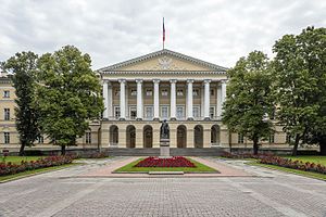
Smolny Institute
Palladian edifice in Saint Petersburg, Russia
Distance: Approx. 1411 meters
Latitude and longitude: 59.94638889,30.39638889
The Smolny Institute (Russian: Смольный институт) is a Palladian edifice in Saint Petersburg that has played a major part in the history of Russia.

Smolninskoye Municipal Okrug
Distance: Approx. 1703 meters
Latitude and longitude: 59.94027778,30.37916667
Smolninskoye Municipal Okrug (Russian: муниципа́льный о́круг Смо́льнинское) is a municipal okrug of Tsentralny District of the federal city of St. Petersburg, Russia. Population: 76,259 (2010 Census); 90,337 (2002 Census).

Alexander Nevsky Bridge
Road bridge in St Petersburg, Russia
Distance: Approx. 1275 meters
Latitude and longitude: 59.92555556,30.39527778
The Alexander Nevsky Bridge (Russian: Мост Алекса́ндра Не́вского, Most Aleksandra Nevskogo) in St Petersburg, Russia is named after the legendary Russian military commander and politician Alexander Nevsky. The bridge connects Alexander Nevsky Square and Zanevsky prospect thus linking the southern and the northern parts of the city. Until 2004, when the Big Obukhovsky Bridge was built, the Alexander Nevsky Bridge was the longest bridge across the Neva River in Saint Petersburg.

Okhta
River in Leningrad Oblast, Russia
Distance: Approx. 1195 meters
Latitude and longitude: 59.94583333,30.4075
The Okhta (Russian: Óхта) is a river in Vsevolozhsky District of Leningrad Oblast and the eastern part of the city of Saint Petersburg, Russia. It is the largest right tributary of the river Neva. It joins the Neva 12 kilometres (7.5 mi) upstream of the Neva's mouth, within the city limits of Saint Petersburg.

Bolsheokhtinsky Bridge
Bridge in St Petersburg, Russia
Distance: Approx. 923 meters
Latitude and longitude: 59.942709,30.401317
Bolsheokhtinsky Bridge (Russian: Большеохтинский мост, before 1917 - Peter the Great Bridge, Russian: Мост Петра́ Вели́кого, Most Petra Velikogo; from 1917 to 1956 - Bolsheokhtensky Bridge, Russian: Большеохтенский мост; also known as Okhtinsky Bridge, Russian: Охтинский мост) is a bridge across the Neva River in Saint Petersburg, Russia. The bridge's length is 334 meters, the width is 23 meters. The bridge features three spans; the central one can be drawn.

Okkervil
River in Russia
Distance: Approx. 756 meters
Latitude and longitude: 59.93444444,30.42138889
The Okkervil (Russian: Оккервиль) is a river in Leningrad Oblast and the eastern part of the city of Saint Petersburg, Russia. It is the largest left tributary of the Okhta. It is 18 kilometres (11 mi) long and 1.5 to 25 metres (4.9 to 82.0 ft) wide.

Smolny Convent
Cathedral complex in Saint Petersburg, Russia
Distance: Approx. 1667 meters
Latitude and longitude: 59.94861111,30.395
Smolny Convent or Smolny Convent of the Resurrection (Voskresensky, Russian: Воскресенский новодевичий Смольный монастырь), located on Ploschad Rastrelli (Rastrelli Square), on the left bank of the River Neva in Saint Petersburg, Russia, consists of a cathedral (sobor) and a complex of buildings surrounding it, originally planned as a convent.

Smolny
City government headquarters in central Saint Petersburg, Russia
Distance: Approx. 1606 meters
Latitude and longitude: 59.948,30.395
Smolny is a place name in central Saint Petersburg, Russia. It is a compound of historically interrelated buildings erected in 18th and 19th centuries. As the most widely known of the buildings, the Smolny Institute, has been used as the seat of the City Governor's Office; its name is associated with city authorities.

Novocherkasskaya (Saint Petersburg Metro)
Saint Petersburg Metro Station
Distance: Approx. 707 meters
Latitude and longitude: 59.929056,30.411778
Novocherkasskaya (Russian: Новочерка́сская) is a station on the Line 4 of Saint Petersburg Metro, opened on December 30, 1985. The station was planned to be named Zanevskaya, but it was ultimately called Krasnogvardeyskaya until 1992; the station's name was changed after its namesake, the Krasnogvardeysky Avenue, was renamed to Novocherkassky. The station is unique as it does not have its own building above ground; one must enter through an underground pedestrian crossing.

Utkina Dacha
18th-century architectural ensemble in St. Petersburg
Distance: Approx. 831 meters
Latitude and longitude: 59.93472222,30.42277778
Utkina Dacha (Utkin's Dacha, Russian: Уткина дача) is an 18th-century architectural ensemble in St. Petersburg, at the junction of the Okkervil and the Okhta rivers. It is included in Russian cultural heritage register under number 7810250000.

Smolny Institute of Noble Maidens
School
Distance: Approx. 1666 meters
Latitude and longitude: 59.9486,30.395
The Smolny Institute of Noble Maidens of Saint Petersburg (Russian: Смольный институт благородных девиц Санкт-Петербурга) was the first women's educational institution in Russia that laid the foundation for women's education in the country. It was Europe's first public educational institution for girls.
Weather in this IP's area
overcast clouds
1 Celsius
-1 Celsius
1 Celsius
1 Celsius
1016 hPa
95 %
1016 hPa
1014 hPa
10000 meters
2 m/s
170 degree
100 %
08:33:36
16:50:25