Country:
Region:
City:
Latitude and Longitude:
Time Zone:
Postal Code:
IP information under different IP Channel
ip-api
Country
Region
City
ASN
Time Zone
ISP
Blacklist
Proxy
Latitude
Longitude
Postal
Route
Luminati
Country
Region
zh
City
rotterdam
ASN
Time Zone
Europe/Amsterdam
ISP
Ram Mobile Data (Netherlands) B.V.
Latitude
Longitude
Postal
IPinfo
Country
Region
City
ASN
Time Zone
ISP
Blacklist
Proxy
Latitude
Longitude
Postal
Route
db-ip
Country
Region
City
ASN
Time Zone
ISP
Blacklist
Proxy
Latitude
Longitude
Postal
Route
ipdata
Country
Region
City
ASN
Time Zone
ISP
Blacklist
Proxy
Latitude
Longitude
Postal
Route
Popular places and events near this IP address

Spijkenisse
Town in South Holland, Netherlands
Distance: Approx. 1731 meters
Latitude and longitude: 51.85,4.33333333
Spijkenisse (Dutch pronunciation: [spɛikəˈnɪsə] ) is a large town in the province of South Holland, Netherlands. Following an administrative reform in 2015, it is part of the municipality of Nissewaard, and has a population of 72,500. It covers an area of 30.27 km2 (11.69 sq mi) of which 4.15 km2 (1.60 sq mi) is water.

Hoogvliet
Place in South Holland, Netherlands
Distance: Approx. 2237 meters
Latitude and longitude: 51.86666667,4.35
Hoogvliet (Dutch pronunciation: [ˈɦoːxflit]) is a borough of Rotterdam, Netherlands. As of 1 January 2023, it had 35,885 inhabitants. There is also a national chain of Dutch supermarkets with the same name.
Hekelingen
Place in South Holland, Netherlands
Distance: Approx. 1641 meters
Latitude and longitude: 51.83333333,4.35
Hekelingen is a village in the Dutch province of South Holland. It is located immediately to the south of Spijkenisse. From 1812 to 1817, Hekelingen was part of Spijkenisse.

Tussenwater metro station
Distance: Approx. 2143 meters
Latitude and longitude: 51.86275556,4.37645833
Tussenwater is an above-ground subway station of the Rotterdam Metro lines C and D. The station is located in the borough Hoogvliet in Rotterdam. The station is situated just before the tracks of lines C and D split. Because of this, the station has four running tracks, which are situated along three platforms.

Poortugaal metro station
Metro station in Albrandswaard, Netherlands
Distance: Approx. 3054 meters
Latitude and longitude: 51.86166667,4.39583333
Poortugaal is an above-ground subway station of Rotterdam Metro line D. The station is located in Poortugaal, a village in the municipality Albrandswaard to the southwest of Rotterdam. It is located north of the village centre of Poortugaal. The station was opened on 25 October 1974.

Hoogvliet metro station
Metro station in Rotterdam, Netherlands
Distance: Approx. 1599 meters
Latitude and longitude: 51.86055556,4.36666667
Hoogvliet is an above-ground subway station of the Rotterdam Metro lines C and D. The station is located in the borough Hoogvliet in Rotterdam and features two side platforms. The station was opened on 25 October 1974. On that date, the North-South Line (currently operated by line D trains) was extended from its former terminus, Slinge, towards Zalmplaat station.

Zalmplaat metro station
Metro station in Rotterdam, Netherlands
Distance: Approx. 955 meters
Latitude and longitude: 51.85527778,4.36277778
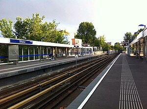
Zalmplaat is an above-ground subway station of the Rotterdam Metro lines C and D. The station is located in the borough Hoogvliet in Rotterdam and features two side platforms. The station was opened on 25 October 1974. On that date, the North-South Line (currently operated by line D trains) was extended from its former terminus, Slinge, towards Zalmplaat station.
Spijkenisse Centrum metro station
Metro station in Spijkenisse, Netherlands
Distance: Approx. 1629 meters
Latitude and longitude: 51.84638889,4.33444444
Spijkenisse Centrum is one of three above-ground subway stations in the Dutch city of Spijkenisse. The station is served by trains of Rotterdam Metro lines C and D and has two side platforms. Located just outside the station is a hospital, as well as a bus station allowing interchange with local and regional buses.

Heemraadlaan metro station
Metro station in Spijkenisse, Netherlands
Distance: Approx. 2099 meters
Latitude and longitude: 51.83777778,4.33166667
Heemraadlaan is one of three (above-ground) subway stations in the Dutch city of Spijkenisse. Architect Carel Weeber was critically acclaimed for his design of the three stations. The Heemraadlaan station is the penultimate stop for trains of Rotterdam Metro lines C and D and features two side platforms.
Boomgaardshoek
Neighborhood of Rotterdam in South Holland, Netherlands
Distance: Approx. 1780 meters
Latitude and longitude: 51.85916667,4.37527778
Boomgaardshoek is a neighborhood of Rotterdam, Netherlands. This part of Hoogvliet was built at the end of 1970s and early 1980s and finished by the end of the 1980s. When they started building this area, it belonged to Poortugaal, in 1986 it became part of Rotterdam.
Westpunt, Rotterdam
Neighborhood of Rotterdam in South Holland, Netherlands
Distance: Approx. 2237 meters
Latitude and longitude: 51.86666667,4.35
Westpunt is a neighborhood of Rotterdam, Netherlands.

Zalmplaat
Neighborhood of Rotterdam in South Holland, Netherlands
Distance: Approx. 666 meters
Latitude and longitude: 51.85,4.36666667
Zalmplaat is a neighborhood of Rotterdam, Netherlands.
Weather in this IP's area
mist
8 Celsius
6 Celsius
7 Celsius
9 Celsius
1032 hPa
85 %
1032 hPa
1032 hPa
4200 meters
3.09 m/s
90 degree
100 %
07:48:16
17:04:18
