89.207.198.73 - IP Lookup: Free IP Address Lookup, Postal Code Lookup, IP Location Lookup, IP ASN, Public IP
Country:
Region:
City:
Location:
Time Zone:
Postal Code:
IP information under different IP Channel
ip-api
Country
Region
City
ASN
Time Zone
ISP
Blacklist
Proxy
Latitude
Longitude
Postal
Route
Luminati
Country
Region
14
City
pljevlja
ASN
Time Zone
Europe/Podgorica
ISP
Serbia BroadBand-Srpske Kablovske mreze d.o.o.
Latitude
Longitude
Postal
IPinfo
Country
Region
City
ASN
Time Zone
ISP
Blacklist
Proxy
Latitude
Longitude
Postal
Route
IP2Location
89.207.198.73Country
Region
pljevlja
City
pljevlja
Time Zone
Europe/Podgorica
ISP
Language
User-Agent
Latitude
Longitude
Postal
db-ip
Country
Region
City
ASN
Time Zone
ISP
Blacklist
Proxy
Latitude
Longitude
Postal
Route
ipdata
Country
Region
City
ASN
Time Zone
ISP
Blacklist
Proxy
Latitude
Longitude
Postal
Route
Popular places and events near this IP address

Pljevlja
Town and municipality in Northern, Montenegro
Distance: Approx. 7 meters
Latitude and longitude: 43.35666667,19.35833333
Pljevlja (Montenegrin: Пљевља, pronounced [pʎêʋʎa]) is a town located in the Northern Region of Montenegro, situated along Ćehotina river. The town lies at an altitude of 770 m (2,530 ft). In the Middle Ages, Pljevlja had been a crossroad of the important commercial roads and cultural streams, with important roads connecting the littoral with the Balkan interior.

Pljevlja Municipality
Municipality of Montenegro
Distance: Approx. 1009 meters
Latitude and longitude: 43.35,19.35
Pljevlja Municipality is located in Northern Montenegro. It covers an area of 1,346 km² and had a population of 30,786 at the 2011 census.

Gradski stadion (Pljevlja)
Distance: Approx. 702 meters
Latitude and longitude: 43.362349,19.362245
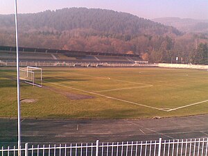
Stadion pod Golubinjom is a multi-use stadium in Pljevlja, Montenegro. It is used mostly for football matches and is the home ground of FK Rudar Pljevlja. Also, local clubs FK Pljevlja and women football club Breznica use this stadium.

Husein-paša's Mosque
Mosque in Pljevlja, Montenegro
Distance: Approx. 7 meters
Latitude and longitude: 43.35666667,19.35833333
Husein-paša's Mosque (Bosnian: Хусеин-пашина џамија, romanized: Husein-pašina džamija) is a well-known mosque in Pljevlja, Montenegro. It was built between 1573 and 1594. It was named after Husein-paša Boljanić who was born in the village of Boljanići, which is close to Pljevlja.

Sanjak of Herzegovina
Administrative division of the Ottoman Empire
Distance: Approx. 7 meters
Latitude and longitude: 43.35666667,19.35833333
The Sanjak of Herzegovina (Turkish: Hersek Sancağı; Serbo-Croatian: Hercegovački sandžak) was an Ottoman administrative unit established in 1470. The seat was in Foča until 1572 when it was moved to Taşlıca (Pljevlja). The sanjak was initially part of the Eyalet of Rumelia but was administrated into the Eyalet of Bosnia following its establishment in 1580.
Pljevlja Power Station
Distance: Approx. 3596 meters
Latitude and longitude: 43.33388889,19.32694444
Pljevlja Power Station is a coal-fired power station in Pljevlja, Montenegro. The plant went into service in 1982 and is the only coal-fired power station in Montenegro. The plant has a generation capacity of 225 MW and produces a third of the country's electricity.

Monastery of the Holy Trinity of Pljevlja
Montenegro Holy Trinity monastery
Distance: Approx. 1469 meters
Latitude and longitude: 43.3699,19.3584
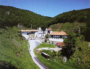
The Holy Trinity Monastery of Pljevlja (Serbian: Манастир Света Тројица Пљеваљска, romanized: Manastir Sveta Trojica Pljevaljska) is a medieval Serbian Orthodox monastery complex (lavra) in Pljevlja, Montenegro. It is located about 37 miles north of Durmitor, and 24 miles from Đurđevića Tara Bridge.

Pljevlja Gymnasium
Charter school in Pljevlja, Montenegro, Pljevlja Municipality, Montenegro
Distance: Approx. 7 meters
Latitude and longitude: 43.35666667,19.35833333
The Pljevlja Gymnasium (Serbian: Пљеваљска гимназија / Pljevaljska gimnazija) is a secondary school in Pljevlja. Since its founding the gymnasium bears the name of its first principal and professor of history: "Tanasije Pejatović Gymnasium" (Гимназија Танасије Пејатовић/Gimnazija Tanasije Pejatović ) It was established by the Metropolitanate of Karlovci on November 18, 1901. Pljevlja Gymnasium was the first gymnasium in the newly formed Province of Pljevlja founded at Berlin Congress, placed under dual occupation and administered by Austro Hungarians and Ottoman Empire.
Crljenice
Village in Northern, Montenegro
Distance: Approx. 2736 meters
Latitude and longitude: 43.3569,19.3922
Crljenice (Montenegrin Cyrillic: Црљенице) is a village in the municipality of Pljevlja, Montenegro.
Durutovići
Village in Northern, Montenegro
Distance: Approx. 2550 meters
Latitude and longitude: 43.336947,19.374348
Durutovići (Montenegrin Cyrillic: Дурутовићи) is a small village in the municipality of Pljevlja, Montenegro.
Potrlica
Village in Pljevlja, Montenegro
Distance: Approx. 2034 meters
Latitude and longitude: 43.34,19.3686
Potrlica (Serbian Cyrillic: Потрлица) is a small village in the municipality of Pljevlja, Montenegro.
Rudnica, Pljevlja
Village in Pljevlja, Montenegro
Distance: Approx. 3551 meters
Latitude and longitude: 43.3744,19.3219
Rudnica (Serbian Cyrillic: Рудница) is a village in the municipality of Pljevlja, Montenegro.
Weather in this IP's area
snow
-3 Celsius
-7 Celsius
-3 Celsius
-3 Celsius
1006 hPa
97 %
1006 hPa
914 hPa
135 meters
2.43 m/s
5.47 m/s
321 degree
100 %
