Country:
 Portugal
Region:
City:
Latitude and Longitude:
Time Zone:
Postal Code:
IP information under different IP Channel
ip-api
Country
Region
City
ASN
Time Zone
ISP
Blacklist
Proxy
Latitude
Longitude
Postal
Route
IPinfo
Country
Region
City
ASN
Time Zone
ISP
Blacklist
Proxy
Latitude
Longitude
Postal
Route
MaxMind
Country
Region
City
ASN
Time Zone
ISP
Blacklist
Proxy
Latitude
Longitude
Postal
Route
Luminati
Country
PTRegion
03
City
guimaraes
ASN
Time Zone
Europe/Lisbon
ISP
Nos Comunicacoes, S.A.
Latitude
Longitude
Postal
db-ip
Country
Region
City
ASN
Time Zone
ISP
Blacklist
Proxy
Latitude
Longitude
Postal
Route
ipdata
Country
Region
City
ASN
Time Zone
ISP
Blacklist
Proxy
Latitude
Longitude
Postal
Route
Popular places and events near this IP address
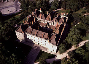
Palace of the Dukes of Braganza
Palace in Guimarães, Portugal
Distance: Approx. 185 meters
Latitude and longitude: 41.44646389,-8.29101111
The Ducal Palace of the Braganza or Palace of the Dukes of Braganza (Portuguese: Paço dos Duques de Bragança) is a medieval estate and former residence of the first Dukes of Braganza, located in the historical centre of Guimarães (Oliveira do Castelo), in the north-western part of Portugal. It was initiated between 1420 and 1422 by Afonso, Count of Barcelos, the illegitimate son of John I of Portugal (and future Duke of Bragança), after his marriage to his second wife. His descendants would occupy the space until the Dukes of Braganza moved to Vila Viçosa, abandoning the palace.
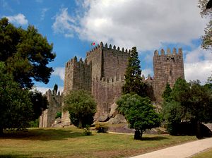
Castle of Guimarães
Medieval castle in Guimarães, Portugal
Distance: Approx. 333 meters
Latitude and longitude: 41.44790833,-8.29035833
The Castle of Guimarães (Portuguese: Castelo de Guimarães) is the principal medieval castle in the municipality Guimarães, in the northern region of Portugal. It was built under the orders of Mumadona Dias in the 10th century to defend the monastery from attacks by Moors and Norsemen. The castle is a military fortification grounded primarily in the late Romanesque period, and elaborated during the early Gothic epoch of Portuguese architecture.

Church of São Miguel do Castelo
Church in Norte, Portugal
Distance: Approx. 249 meters
Latitude and longitude: 41.44728611,-8.29094722
The Church of São Miguel do Castelo (Portuguese: Igreja de São Miguel do Castelo) is a medieval church in the civil parish of Oliveira do Castelo, municipality of Guimarães, in the northern district of Braga of Portugal. The church is emblematically linked to the foundation of the Portuguese Kingdom. Legend suggests that it was the sight of the baptism of the young Afonso Henriques.

Guimarães
Municipality and city in Norte, Portugal
Distance: Approx. 185 meters
Latitude and longitude: 41.445,-8.29083333
Guimarães (European Portuguese pronunciation: [ɡimɐˈɾɐ̃jʃ] ) is a city and municipality located in northern Portugal, in the district of Braga. Its historic town centre has been listed as a UNESCO World Heritage Site since 2001, in recognition for being an "exceptionally well-preserved and authentic example of the evolution of a medieval settlement into a modern town" in Europe. The Nicolinas are the city's main festivities.

Igreja de Nossa Senhora da Oliveira
Collegiate church in Guimarães, Portugal
Distance: Approx. 298 meters
Latitude and longitude: 41.44294,-8.29255
Igreja de Nossa Senhora da Oliveira is a collegiate church in Guimarães, Portugal. It is classified as a National Monument.

Historic Centre of Guimarães
UNESCO World Heritage Site in Guimarães, Portugal
Distance: Approx. 208 meters
Latitude and longitude: 41.44373111,-8.29280306
Historic Centre of Guimarães is an urban space of the city of Guimarães, in Portugal, tracing back to medieval age covering an area of 16 hectares and retaining many buildings from the medieval age until 19th century. Since 2001, it is declared as a World Heritage Site of UNESCO. Guimarães is closely linked to the formation of national identity and of Portuguese language in 12th century. It is the native city of Afonso Henriques, the first king of Portugal, who in 1139, declared independence of the country.

Oliveira, São Paio e São Sebastião
Civil parish in Norte, Portugal
Distance: Approx. 290 meters
Latitude and longitude: 41.443,-8.293
Oliveira, São Paio e São Sebastião (officially: União das Freguesias de Oliveira, São Paio e São Sebastião) is a civil parish in the municipality of Guimarães, Portugal. It was formed in 2013 by the merger of the former parishes Oliveira do Castelo, São Paio, and São Sebastião. The population in 2021 was 7,832, in an area of 1.55 km2.

Santa Maria Street
Street in Guimarães, Portugal
Distance: Approx. 171 meters
Latitude and longitude: 41.444069,-8.292782
The Santa Maria Street (Portuguese: Rua de Santa Maria) is a street of medieval origin in the historic centre of Guimarães, being for many centuries the most important street in Guimarães and home to some of its elite. The street currently connects the Oliveira and the Santiago Square to the Carmo Square. It is already referred to by the name “Rua de Santa Maria” in documents that date to the 12th century, although its upper section was given the old name of Rua da Infesta (Infesta Street).

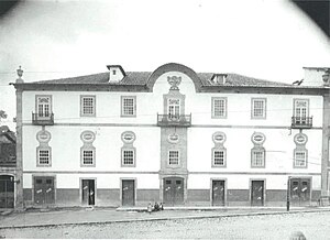
Raul Brandão Municipal Library
Municipal library of Guimarães
Distance: Approx. 147 meters
Latitude and longitude: 41.44428,-8.29293
The Raul Brandão Municipal Library (Portuguese: Biblioteca Municipal Raul Brandão) is located in Guimarães, and it has been part of the National Public Reading Network (Rede Nacional de Leitura Pública) since 1987. The library was created after the Portuguese writer Branquinho da Fonseca was invited by Azeredo Perdigão, in 1958, to found and direct the Library services of the Calouste Gulbenkian Foundation.
Padrão do Salado
14th century monument in Guimarães, Portugal
Distance: Approx. 307 meters
Latitude and longitude: 41.44284,-8.29279
The Padrão Comemorativo da Batalha do Salado, commonly referred to as just Padrão do Salado, is a 14th-century gothic monument located in the freguesia of Oliveira, São Paio e São Sebastião, inside the Historic Center of Guimarães area, in Portugal. Located in front of the Church of Nossa Senhora da Oliveira, the Padrão do Salado has been classified as a National Monument since 1910.
Afonso Henriques Theatre
Former theatre in Guimarães, Portugal
Distance: Approx. 418 meters
Latitude and longitude: 41.44193889,-8.29176944
The Afonso Henriques Theatre (or Dom Afonso Henriques Theatre; Portuguese: Teatro Dom Afonso Henriques), was the main theatre of Guimarães from 1853 until its replacement by the Jordão Theatre in the late 1930s.

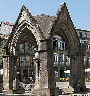
Santiago Square
Medieval town square in Guimarães, Portugal
Distance: Approx. 249 meters
Latitude and longitude: 41.44337,-8.29319
The Santiago Square, or São Tiago Square, (Portuguese:Praça de Santiago), is a medieval town square located in the city of Guimarães. It is fully included in the UNESCO World Heritage Site of the Historic Centre of Guimarães.
Weather in this IP's area
overcast clouds
19 Celsius
19 Celsius
18 Celsius
19 Celsius
1020 hPa
88 %
1020 hPa
995 hPa
10000 meters
0.89 m/s
3.13 m/s
247 degree
100 %
07:29:03
19:16:54